

April Fools’ Day: Google Maps 8-Bit Version Prank For NES
Google Maps 8-bit version has been released on this years' April Fool's Day. (Photo: maps.google.com)
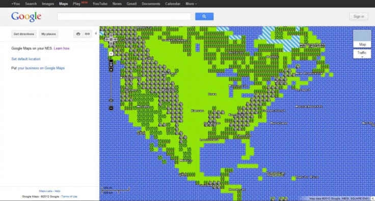
There are several viewing options in Google Maps, such as traffic, street view, satellite imaging, and others. But what if Google released a Quest Mode -- like your favorite old-school Nintendo game -- that allowed people to take a Legend of Zeldaesque 8-bit adventure around the world?
Google's latest April Fools' Day prank provides that functionality: The company has given its geolocational service an 8-bit skin that looks like a hybrid between early versions of Sim City and the late 1980s-early 1990s versions of The Oregon Trail. Google created an instructional video showing users how to connect Google Maps to a Nintendo Entertainment System (NES).
Google provides services for a wide range of devices from desktop computers to mobile devices including tablets, Ken Tokusei, product management director at Google, said in the video. But we long neglected one of the most popular computer systems ever sold, and I'm here to introduce Google Maps 8-Bit version as a first product for NES.
The video demonstrates the process by which the Google Maps cartridge should be connected to the NES using a 56k dial-up modem. A Google representative describes how the company was able to bring Nintendo's legacy device to the Internet era: We run more than a hundred thousand servers to overcome the NES's technical limitations.
The video shows a family using the cartridge and even explains that blowing into the cartridge will relieve any technical complications. Google Maps 8-bit version is completely functional on the Google Maps website, too, though it's unclear for how long.
To see the video demonstration, click below:
© Copyright IBTimes 2024. All rights reserved.
-

IMF Says Global Debt Levels Face 'Great Election Year' Risk
-

Divisions Among Colombia's FARC Dissidents Complicate Peace Talks
-

French Far Right Gets Youthful Vibe With 28-year-old Leader
-

US Fed's Powell Says Inflation Fight May Take 'Longer Than Expected'
-

Mideast-related Oil Price Spike Threatens 'Relatively Good' Economic Outlook: IMF Chief Economist
-

Wine Growers 'On Tip Of Africa' Race To Adapt To Climate Change
-

Despite Olympic Truce, Games Wrestle With Political Fallout
-

What Will The Fed Do With The Latest Inflation Numbers?
-

US Retail Sales Up More Than Expected In March
-

Alexandre De Moraes: Brazil Judge In Feud With Elon Musk


