

Hurricane Irene 2011: Why Approaching Storm Could Be One of Worst to Strike Florida in Years
Hurricane Irene, the first hurricane of the 2011 Atlantic season, is tracking toward Florida as a possible Category 2 storm and could pack days of high winds and rain, making it one of the most damaging storms to hit the state in years.
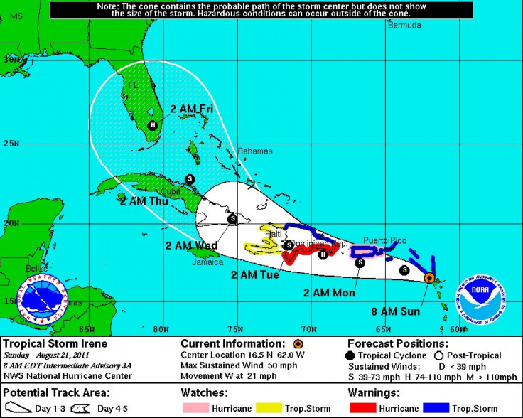
While forecast models are always changing, depending upon timing, Irene is currently expected to reach the tip of the state by late Thursday or early Friday morning before riding directly north into Florida's heart.
Here's why Irene is a threat:
--Duration of the Storm. Wind speeds are often the gauge many use in determining the damaging power of a hurricane but that's often not the case. Duration of the storm over land, yielding heavy rainfall, combining with high winds and spawned tornadoes typically result in the worst storms.
Forecasts suggest Hurricane Irene will make landfall in Florida as a Category 2 storm, with sustained winds of 100 to 110 miles per hour. The winds will be damaging, and Florida will encounter storm surge along the coast. But if Irene strikes at the tip of Florida and rides north into the state for days as some models currently show, rainfall combined with wind and tornadoes will be the biggest threat, and most damaging element, potentially impacting the entire state except for the western panhandle.
Some models show Irene may strike Florida's tip late Thursday or Friday, and remain as a category 2 storm by early Saturday morning near Jacksonville. If that happens, two days of torrential rainfall and wind and possibly tornadoes and lightening could make Hurricane Irene a force to be reckoned with in Florida.
--Scope of the Storm. Florida has 18.8 million residents, making the Sunshine state the fourth largest in the U.S. The state has historically suffered severe damage from hurricanes, because of its peninsula positioning and exposure to water, with the Gulf of Mexico on the western side and the Atlantic on the eastern side.
Because of this, hurricane's often maintain strength after hitting Florida longer than they do when striking land in other regions because of abundant warm waters to draw strength from. But in the case of Hurricane Irene, forecast models show Florida potentially at great risk because the storm could cover almost the entire state, except for portions of the panhandle, before dissipating after a couple of days.
If that happens, Hurricane Irene could be one of the most damaging storms to ever hit the state even if it makes land as only a Category 2 storm.
--Housing Vulnerability. Florida suffers the most in economic damage when storms ravage the inner portions of the state. A strong storm that makes landfall as a Category 3, or 4 even, that strikes and quickly moves out to sea, or quickly inland, is typically not as damaging as a storm that pummels the inner portion of the state.
This is because Florida has significant sub-standard housing lived in by its 18.8 million residents. Trailers, and cinder block homes are at great risk to sustained high winds, rain, and tornadoes. A storm that covers most of the state, and lingers for days, holds the most risk for destruction.
--Storm Surge. One of the most discussed impacts of a hurricane, storm surge depends on timing as well. If a storm lands at a low-lying area at high tide with strong winds, storm surge can be far worse. If it lands at low tide and the storm is weakening, it can have less impact. But if Hurricane Irene strikes South Florida as a Category 2 storm, storm surge will make a damaging impact at some level no matter what.
Some models suggest because of warm waters Hurricane Irene could strengthen to a Category 3 storm, also, making landfall along the Florida Keys. If that happens, the storm surge could be significant.
It's still early in the forecasting of Hurricane Irene, and the threat level is likely to change as forecast confidence increases over the next 24 to 48 hours. But early indications suggest the storm could be a major force for the state of Florida later this week, and residents are advised to pay close attention to forecasts and evacuation orders, should any be posted.
The current model suggests timing for a Hurricane Irene strike on the U.S. could be as soon as Thursday for South Florida, and Thursday night and into Friday for the Florida peninsula. Residents as far north as Jacksonville should stay tuned for developments as well, since many models show Hurricane Irene may advance that far north, still at hurricane strength, by Friday and Saturday.
© Copyright IBTimes 2024. All rights reserved.
-

Mass Cancellations Loom Despite French Air Union Cancelling Strike
-

Recycled 'Zombie' Misinformation Targets US Voters
-

Hackers Leak Part Of Source Code Of El Salvador's Bitcoin Wallet
-

Azerbaijan Says 'Closer Than Ever' To Armenia Peace Deal Amid Border Talks
-

How UK's Biggest Water Supplier Sank Into Crisis
-

Taiwan Hit By Dozens Of Strong Aftershocks From Deadly Quake
-

Gaza Health System 'Completely Obliterated': UN Expert
-

In Ecuadoran Amazon, Butterflies Provide A Gauge Of Climate Change
-

'Thank You, America:' Zelensky And Netanyahu Applaud House Passage Of Foreign Aid Package
-

Women Journalists Bear The Brunt Of Cyberbullying


