

Alaska Weather: Similar Alaskan Storm Hit Nome in 1974

A life-threatening storm of epic magnitude battered Western Alaska Wednesday morning. The National Weather Service (NWS) warned that it could be one of the worst storms on record for the state.
However, this isn't the first storm of its magnitude to strike Western Alaska. Meteorologists at Alaska's NWS compare the 2011 storm to a 1974 storm - the strongest in Nome's 113 years of weather records. That storm occurred at almost the same time of year (November 11-12).
Nome took the brunt of the squall. A surge of over 13 feet pushed beach driftwood above the level of the previous storm of its type in 1913. Water overflowed from the harbor, went over the sea wall in Nome, and rose to a depth of over 5 feet in the low lying areas in western portions of the city.
The absence of tide gages and quantitative water data made it difficult to assess the magnitude of the storm surge. However, the shallow shores of Norton Sound made it possible to assess the line of debris. The storm produced the worst coastal flooding on record for the region. Though no lives were lost, the flooding caused between $12 and $15 million in damages.
Local TV station KTUU has an eye-opening gallery of photos from the aftermath of the 1974 storm.
The storm currently churning in the Bering Sea is similar to its historic counterpart; however there are some notable differences.
Major differences between the 1974 storm and this upcoming storm include the fact that tides were much greater in the 1974 storm, NWS said. However, sea ice extent is currently much lower than it was in 1974, thus providing no protection along the coast and greater fetch.
Where do these storms come from?
The current storm is the result of warm air in the Pacific Ocean tapping into the cold air off Siberia, picking up speed in a jet stream near there and then intensifying as it moves into the Bering Sea (where storms typically intensify).
Because the storm has an unusually long fetch line (the length of the wind blowing in a single direction over water) it pushes the water up, creating large waves. Meteorologists estimate that the fetch line may be up to 1,000 miles.
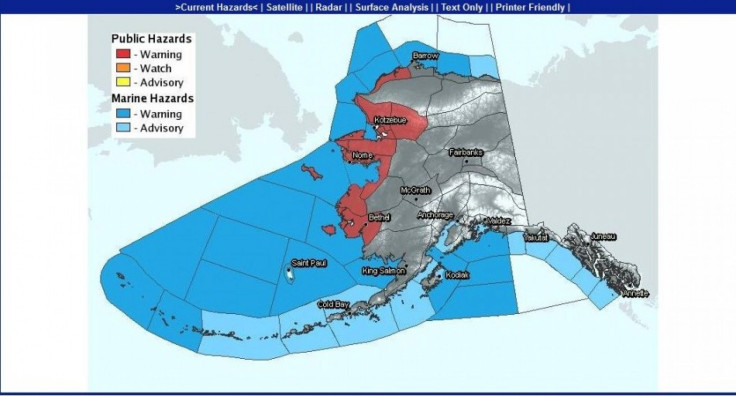
The rare storm packs hurricane-force winds. It's also expected to produce heavy snowfall, sever erosion, and widespread coastal flooding along much of Alaska's west coast on Wednesday, the National Weather Service said.
Blizzard conditions prevailed overnight on Tuesday across Western Alaska with maximum sustained winds of 60mph and gusts up to 80mph.
National Weather Service Meteorologists in Fairbanks reported a rise in sea levels and an upsurge of over three feet. They said the sea could rise another four feet, putting the tiny coastal communities at particular risk for wind and flood damage. Already, the Fairbanks office has received reports of some roofs blowing off in Nome, where water reached the base of buildings.
The city of Nome, one of the largest in Western Alaska with 3,600 residents, mandated evacuations late Tuesday as the storm moved inland from the Aleutian Islands.
Officials are concerned for Alaska natives in 18 villages in the region. They were particularly worried about the village of Kivalina, one of the state's most threatened communities because of erosion. Kivalina gained national attention over the summer when mysterious orange goo washed up along the small town's shores.
Many coastal residents secured their homes and headed to emergency shelters on Tuesday ahead of the storm.
It remains to be seen whether the 2011 storm will prove as devastating as the one in 1974.
© Copyright IBTimes 2024. All rights reserved.
-

IMF Says Global Debt Levels Face 'Great Election Year' Risk
-

Divisions Among Colombia's FARC Dissidents Complicate Peace Talks
-

French Far Right Gets Youthful Vibe With 28-year-old Leader
-

US Fed's Powell Says Inflation Fight May Take 'Longer Than Expected'
-

Mideast-related Oil Price Spike Threatens 'Relatively Good' Economic Outlook: IMF Chief Economist
-

Wine Growers 'On Tip Of Africa' Race To Adapt To Climate Change
-

Despite Olympic Truce, Games Wrestle With Political Fallout
-

What Will The Fed Do With The Latest Inflation Numbers?
-

US Retail Sales Up More Than Expected In March
-

Alexandre De Moraes: Brazil Judge In Feud With Elon Musk


