

California Wildfire Latest Maps: Where Are The Flames Headed To?
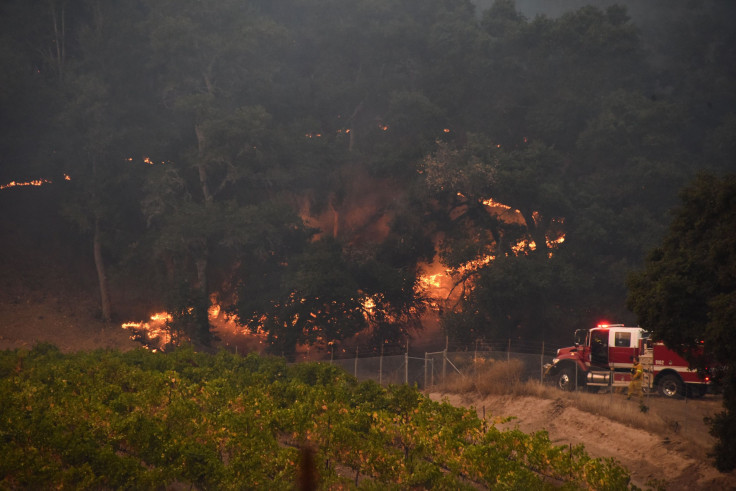
Wildfires in California Wine County continued to burn over Thursday as fire crews began to make slow progress. New deaths confirmed Thursday took the toll to 31, making this the deadliest week of wildfires in Californian history.
Reports on Thursday also said fires in many parts still burned out of control and grew to more than 300 square miles (777 square kilometers) — almost the size of New York City.
ABC News affiliate, KABC-TV quoted fire officials saying personnel was closely watching the communities in Calistoga, Sonoma, Geyserville, Middletown and Solano counties as of late Thursday.
Evacuation advisories, which mandate that the people leave the area if the situation worsened — were also issued for those living east of Silverado Trail, Soscol Avenue, Highway 221, Highway 29 and north of Jameson Canyon Road. The advisory also applied to Sonoma County, Palomino Lakes as well as parts of Windsor and Healdsburg. In Solano County, warnings were issued for Interstate 80 and west of Suisun Valley Road.
The National Weather Service (NWS) issued another red flag warning for the East Bay hills and North Bay mountains. The warning is valid from 5 p.m. Friday through 11 p.m. Saturday.
A new Red Flag Warning has been issued for the North and East Bay Hills and is valid from 5 PM Friday through 11 PM Saturday. pic.twitter.com/I2lvCdjbnv
— NWS Bay Area 🌉 (@NWSBayArea) October 13, 2017
The wildfires are expected to be fanned further by gusty winds and dry air.
Rick Canepa, a meteorologist with the NWS told SF Gate the forecasters expect the winds to pick up speed again while the humidity would not rise. According to Canepa, north to northeast winds with speeds of 20 to 30 miles per hour were predicted by models, but gusts could reach 40 to 50 miles per hour. High-resolution models also predicted gusts of up to 60 miles per hour, he added, with northern Sonoma and Napa county as areas of particular concern.
Meanwhile, as of Thursday evening, voluntary evacuation orders were lifted in several parts of the state, including Silverado Country Club, Monticello Park and The Avenues in Napa County.
Google’s 2017 Statewide Fire Map for California listed all the active fires in the state, allowing people who are not in the midst of the smoke to get a better understanding of the path of the fire.
The National Wildfire Coordinating Group also released a map that enables tracking of the fire. It can be found here.
Forecast for areas that would be affected by smoke was also released.
Here's the HRRR model near surface smoke forecast through Friday afternoon. The stationary red areas on the map are current fire perimeters in the North Bay. #cawx #NorthBayFires pic.twitter.com/qtA5SQpVrR
— NWS Bay Area 🌉 (@NWSBayArea) October 13, 2017
Sonoma County Sheriff Robert Giordano said officials were still investigating hundreds of reports of missing people and that recovery teams would begin conducting "targeted searches" for specific residents at their last known addresses.
"We have found bodies almost completely intact, and we have found bodies that were nothing more than ash and bones," the sheriff said.
"We will do everything in our power to locate all the missing persons, and I promise you we will handle the remains with care and get them returned to their loved ones," he added.
© Copyright IBTimes 2024. All rights reserved.
-
French Air Traffic Controller Strike Threatens Flight Chaos
-

Azerbaijan Says 'Closer Than Ever' To Armenia Peace Deal Amid Border Talks
-

How UK's Biggest Water Supplier Sank Into Crisis
-

Taiwan Hit By Dozens Of Strong Aftershocks From Deadly Quake
-

Gaza Health System 'Completely Obliterated': UN Expert
-

In Ecuadoran Amazon, Butterflies Provide A Gauge Of Climate Change
-

50 Years On, Vintage Vehicles To Reenact Portugal's Carnation Revolution
-

Conflicts Push Military Spending To 'All-time High': Report
-

'Thank You, America:' Zelensky And Netanyahu Applaud House Passage Of Foreign Aid Package
-

Women Journalists Bear The Brunt Of Cyberbullying


