

East Coast Quake: Virginia Nuclear Plant Shuts Down, Others Unaffected
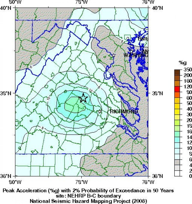
A 5.9 magnitude earthquake centered northwest of Richmond, Va., shook much of Washington, D.C., and was felt as far north as Rhode Island and New York City.
The earthquake sent hundreds of people spilling into the street a block from the White House and buildings were also evacuated in North Carolina.
The U.S. Geological Survey said the earthquake was 3.7 miles deep. Shaking was felt at the White House and all over the East Coast, as far south as Chapel Hill, N.C. Parts of the Pentagon, White House and Capitol were evacuated.
There were no immediate reports of injuries or damages.
The earthquake was centered near Louisa, Va., which is northwest of Richmond and south of Washington.
Two reactors at the North Anna Station in Mineral, Va., were stopped, the NRC said. The plant lost off-site power, but diesel generators are operating, a spokesman for the Nuclear Regulatory Commission said.
The Virginia shutdown came automatically after the strong quake in the region. The shutdown was safe and represented no danger to the public, the NRC said.
The quake was felt along the East Coast as far north as Canada.
Dominion's two-unit Surry plant in Gravel, Virginia, continues to operate normally.
Entergy's Indian Point nuclear power plant located north of New York city was operating normally, a spokesman for the company said.
Nine other plants in the region between Virginia and New Jersey declared an unusual event, the lowest of the NRC's emergency classification ratings, but all continued to operate at full power.
© Copyright IBTimes 2024. All rights reserved.
-

IMF Says Global Debt Levels Face 'Great Election Year' Risk
-

Divisions Among Colombia's FARC Dissidents Complicate Peace Talks
-

French Far Right Gets Youthful Vibe With 28-year-old Leader
-

US Fed's Powell Says Inflation Fight May Take 'Longer Than Expected'
-

Mideast-related Oil Price Spike Threatens 'Relatively Good' Economic Outlook: IMF Chief Economist
-

Wine Growers 'On Tip Of Africa' Race To Adapt To Climate Change
-

Despite Olympic Truce, Games Wrestle With Political Fallout
-

What Will The Fed Do With The Latest Inflation Numbers?
-

US Retail Sales Up More Than Expected In March
-

Alexandre De Moraes: Brazil Judge In Feud With Elon Musk


