

Google Earth Timelapse Gives A Look At An Evolving Planet That Spans Decades

Google Earth Timelapse is a new interactive website from the search giant that lets users view decades of change on Earth through time-lapsed satellite imagery.
Google Earth Timelapse is the result of a partnership between Google, the United States Geographical Survey, NASA and Time. In Google’s blog post announcing the Timelapse project, engineering manager Rebecca Moore said, “Today, we're making it possible for you to go back in time and get a stunning historical perspective on the changes to the Earth’s surface over time.”
Each interactive time-lapsed image was created by combining millions of images that were collected from space over the course of several decades. Google worked with NASA and the USGS to make use of their Landsat technology, which includes several satellites orbiting Earth. The Landsat satellites have been collecting information and images of Earth since 1972. Google has been working on the Timelapse project since 2009 and combed through 909 terabytes of data -- more than 2 million photos -- to create its spin on Earth’s development.
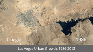
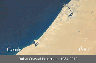
The Google Earth Timelapse project includes an interactive look at the development of Las Vegas and Dubai; coal mining in Wyoming; the drying of Lake Urmia in Iran; the deforestation of the Amazon rainforest in Brazil; and the effects of climate charge on the Columbia Glacier in Alaska. The CREATE Lab at Carnegie Mellon University helped developed the Web experience for the project.
In conjunction with Google, Time created an in-depth website dedicated to exploring each time-lapsed image in detail. The site also features videos that examine the context surrounding the decades of change. Dubai, which has changed from a city with 300,000 people to a metropolis with more than 2 million over those decades, is featured on the site, Time noted.
The Google Earth Timelapse project's main goal is to increase understanding of how population growth, urban expansion and climate change can impact Earth.
© Copyright IBTimes 2024. All rights reserved.
-

Taiwan Hit By Dozens Of Strong Aftershocks From Deadly Quake
-

Gaza Health System 'Completely Obliterated': UN Expert
-

In Ecuadoran Amazon, Butterflies Provide A Gauge Of Climate Change
-

50 Years On, Vintage Vehicles To Reenact Portugal's Carnation Revolution
-

Conflicts Push Military Spending To 'All-time High': Report
-

'Thank You, America:' Zelensky And Netanyahu Applaud House Passage Of Foreign Aid Package
-

Women Journalists Bear The Brunt Of Cyberbullying
-
US Aid Shows Ukraine Will Not Be 'Second Afghanistan': Zelensky
-

Elon Musk's X Fights Australian Watchdog Over Church Stabbing Posts
-

Ukraine, Israel, TikTok: The Massive Aid Package Before US Congress


