

Google Project Tango: Watch The 3D-Mapping Smartphone Ride An Autonomous Drone
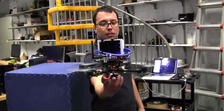
Researchers from the University of Pennsylvania created a drone capable of correcting its own flight path with the help of Project Tango, the sensor-equipped smartphone capable of creating a 3D-map of its own surroundings. The phone prototype only came out in February, and a tablet version is due on the market in June.
Google Inc. (NASDAQ:GOOG) previously partnered with NASA to send Project Tango to map space flights, but meanwhile on Earth, UPenn researchers combined the device with an off-the-shelf drone to create a flier capable of steadying itself, even when knocked around by outside forces.
Professor Vijay Kumar and his students were determined to build an autonomous, or self-navigating drone, using readily-available technology. They combined Project Tango -- equipped by Google’s Advanced Technology and Projects (ATAP) division with a depth sensor, a motion-tracking camera and two processors capable of deducing a detailed, three-dimensional map of its surroundings -- with a Parrot AR.Drone 2.0 for the project.
The team’s drone can easily reposition itself when pushed off of its predetermined course, with the researchers largely crediting Google's sensor technology for the feat. Watch a demonstration of GRASP team’s quadrocepter in flight.
© Copyright IBTimes 2024. All rights reserved.
-

How The US Helped Counter Iran's Attack On Israel
-

How The Premier League Title Race Stands With Six Games To Go
-

In Haiti, Political Parties Lash Out At PM Over Council Limbo
-

Police Probe Killer's Targeting Of Women In Sydney Mall Attack
-
In Tehran, Fears Grow Of Potential Iran-Israel War
-

Asia-Pacific Gets New Weapon In Fight Against Drug-resistant TB
-

Ohtani Translator Case Shines Light On Insatiable Gambler
-

Fewer Showers, Less Laundry, As Water Cuts Hit Bogota
-

Stretched Valuations, Interest Rate Expectations, Make Stocks Vulnerable To Sell-offs
-

Funding Shortfall Threatens Internet Access For Millions Of Low-Income Americans


