

Gulf Oil Workers Evacuated as Storm Gathers [PHOTOS]

Whether Hurricane Katia will have any impact on the United States is still uncertain, but forecasters are keeping a watchful eye on a new tropical threat in the Gulf of Mexico, which they say could become a powerful storm.
A tropical disturbance with increasingly organized thunderstorm activity is over the Gulf of Mexico and it seems to be hitting closer to home.
The Weather Channel said numerous computer models forecast this system developing into a tropical depression or tropical storm late this week.
At 2 a.m. EDT Friday, the National Hurricane Center said the system is nearly stationary about 240 miles (385 kilometers) southwest of the Mississippi River mouth. The depression could become a tropical storm later today before reaching Louisiana over the weekend.
A slow northwestward drift is expected to start later today followed by a turn to the north tonight or Saturday, the center said. Gradual strengthening is forecast during the next 48 hours.
Forecasters say they have many, many days to monitor Hurricane Katia, which upgraded to a Category 1 hurricane early Thursday morning, and is now located far out in the central Atlantic Ocean. They say it is too early to determine if Katia will ever affect any land areas.
However, the primary threats at this time from the system in the Gulf of Mexico show that there could be torrential flooding rain and at least some coastal flooding, high surf and rip currents, which is a vastly underrated killer, according to The Weather Channel.
Areas most at risk
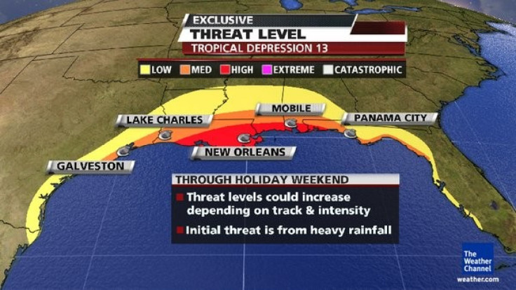
Those areas most at risk from the tropical system in the Gulf of Mexico are Galveston, Lake Charles, Mobile, New Orleans, and Panama City. Forecasters say the threat level could increase throughout the holiday weekend. That level of threat could also increase depending on the track and intensity of the system. They say the initial threat is from heavy rainfall.
Louisiana Governor Bobby Jindal on Thursday evening declared a state of emergency. He cited the likelihood that coastal and inland areas would be drenched by up to 15 inches of torrential rain within 48 hours.
Oil companies evacuate workers
That the threat could increase was enough to send oil companies packing, as they began evacuating workers in the Gulf of Mexico ahead of the potential powerful storm.
Oil companies like Shell, Exxon Mobil and BP were prompted to shut down production, and Chevron has said it was evacuating non-essential workers, but announced no impacts to production, according to Voice of America reports.
The storm was moving through a heavy concentration of oil and gas platforms off the Louisiana coast and could potentially crimp supplies from the Gulf, which accounts for about 30 percent of U.S. oil and 12 percent of its gas, according to Reuters.
Only a fraction of Gulf output was shut as of Thursday - 5.7 percent of oil supply and 2.4 percent of gas supply, according to the U.S. government. It will likely rise significantly in coming days as the storm develops.
The tropical depression, which would be named Lee if it reaches tropical storm status, could spur torrential rains and coastal flooding from the Florida Panhandle to Texas-Louisiana border, according to National Hurricane Center Director Bill Read.
We've got a huge area of moisture, Read told reporters in Miami. We've got a developing wind field. We're probably going to see some tremendous rain amounts and the corresponding flooding that goes with that.
Emergency crews in the eastern U.S. are still helping residents recover from Hurricane Irene, which damaged parts of the region just days ago with flood waters. Parts of the states of Vermont, Connecticut, New York and New Jersey were damaged because of Hurricane Irene's high winds and heavy rains. Millions of people are still without electricity and at least 45 deaths have been associated with Irene's passing over the Eastern Coast of the U.S.
Hundreds of roads along that coast are in need of repair because of damages sustained from Irene.
U.S. President Barack Obama has signed disaster declarations for New York, New Jersey and North Carolina in order to make federal funding available for recovery efforts. The damage is estimated to be approximately $10 billion.
Slow-moving cyclones cause flooding
Slow-moving tropical cyclones bring flooding rainfall, and the disturbance that looms over the Gulf should fall into that category, according to The Weather Channel.
Forecasters say steering winds initially seem to be weak, as the jet stream remains far to the north, which is typical for late summer. Therefore, those in the area should expect a slow-moving low to produce heavy rainfall over parts of the Gulf Coast the next several days.
Tropical cyclones form tropical storms when winds exceed 39 miles per hour (63 kilometers per hour). They turn into hurricanes when winds top 74 miles per hour. Lee would be the 12th named storm of the busy 2011 Atlantic hurricane season.
Texas is currently in a severe drought and rains from the developing weather system could bring some relief.
Bands of rain are already feeding into the central Gulf Coast, The Weather Channel states, noting also that a large swath of the Gulf Coast is expected to see rainfall totaling more than 4 inches, with local rainfall amounts more than 10 inches likely in parts of southeast Louisiana, southern Mississippi and southern Alabama through early-mid next week.
Even with long-term drought, these massive rainfall totals could eventually trigger flash flooding.
On Thursday, the system was about 227 miles south-southeast of Mississippi Canyon, one of two areas in the Gulf with major concentrations of oil and gas infrastructure, Aaron Studwell, a meteorologist with Wilkens Weather, told Reuters. The system was about 250 miles south-southeast of the other large concentration in Green Canyon, Studwell added.
Hurricane season peaks in September
The hurricane season normally peaks in September, and experts have predicted an active 2011 hurricane season with about eight to 10 hurricanes possible ? slightly more than normal.
It was in late August 2005 that Hurricane Katrina formed over the Bahamas and crossed into southern Florida as a Category 1 hurricane. It causes deaths and flooding in that state before rapidly strengthening in the Gulf of Mexico. Katrina weakened slightly before making a second landfall as a Category 3 storm on Aug. 29 in southeast Louisiana, and caused severe damage along the Gulf coast from central Florida to Texas. Much of that damage was reportedly due to the storm surge.
New Orleans and Louisiana recorded the most significant deaths because of a failed levee system. About 80 percent of the city was flooded and water lingered for weeks.
Swift response from officials
Though Irene was much larger than Katrina, it lacked Katrina's intensity. The latter carried a heftier price tag too: $93.7 billion in damage and more than 1,800 lives lost.
Officials didn't take any chances with Irene when it came to emergency management, as evacuations were ordered in advance throughout the East Coast.
On the other hand, Katrina appeared to have taken the residents of Gulfport, Biloxi and other Gulf Coast cities by surprise, as The Washington Post noted that there have been reports of stricken residents rushing to evacuate when it was nearly too late.
Perhaps it is because of these hard-learned lessons that the government moved so quickly in handling evacuations, responses, recovery and relief efforts associated with Hurricane Irene.
© Copyright IBTimes 2024. All rights reserved.
-

Mass Cancellations Loom Despite French Air Union Cancelling Strike
-

Recycled 'Zombie' Misinformation Targets US Voters
-

Hackers Leak Part Of Source Code Of El Salvador's Bitcoin Wallet
-

Azerbaijan Says 'Closer Than Ever' To Armenia Peace Deal Amid Border Talks
-

How UK's Biggest Water Supplier Sank Into Crisis
-

Taiwan Hit By Dozens Of Strong Aftershocks From Deadly Quake
-

Gaza Health System 'Completely Obliterated': UN Expert
-

In Ecuadoran Amazon, Butterflies Provide A Gauge Of Climate Change
-

'Thank You, America:' Zelensky And Netanyahu Applaud House Passage Of Foreign Aid Package
-

Women Journalists Bear The Brunt Of Cyberbullying


