

How La Niña Affects Winter 2017, Global Temperatures In 2018

According to a report Thursday by the National Oceanic and Atmospheric Administration (NOAA), the United States stands to be affected by La Niña weather conditions which will influence the winter of 2017 and the early part of 2018.
The report stated that a weaker form of La Niña has already arrived, impacting oceanic and atmospheric conditions in October and early November. This month has already begun recording cooler-than-average sea-surface temperatures near the equator. The sudden change in the oceanic temperature has been attributed to La Niña.
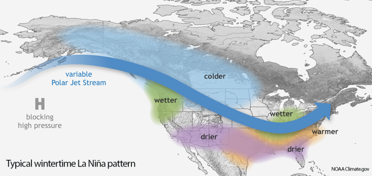
La Niña (a Spanish term meaning “little girl”) is known to cause temperatures of the central and eastern equatorial Pacific Ocean to fall below average. Winters in the inland northwest, typically impacted by this weather condition in the past, were characterized by normal precipitation and below normal temperatures. But this year, the forecast is for a wetter winter in the region.
It is often considered to be the opposite of El Niño, which heats up the Pacific Ocean waters instead. Along with La Niña, El Niño-Southern Oscillation, or ENSO, has become one of the leading determinants of weather patterns in North America, particularly during the winter.
According to NOAA, La Niña is not only going to affect the Pacific Ocean at a surface-level, but also cool deeper waters in the ocean. Due to La Niña, the Pacific will also receive less-than-average rate of precipitation.
And how will La Niña affect the United States? People living in Alaska and down across the provinces of northwest and western Canada, into the northern plains and upper Midwest should brace for cooler-than-average winters, Mashable reported. States in the U.S. spread across the Pacific northwest, and also those in the Midwest, will experience a wetter-than-average winter.
The north west mountains of Colorado, for example, is expected to receive snowfall in the winter if this weathering pattern holds, given that the jet stream orients itself from northwest to southeast over Washington, Oregon and Idaho, according to CBS Denver. However, if the jet stream travels south, chances of the mountains as well as the north of Interstate 70 receiving light to moderate snowfall are diminished.
There is also a 50 percent chance that the weaker form of La Niña will persist till February through April 2018. This means that in all likelyhood, 2018 might end up being a cooler year than 2017, which was largely influenced by the heat strain brought on by El Niño, becoming one of the top three warmest years, according to records dating back to 1880.
Nevertheless, due to the weak nature of La Niña, there is a chance that 2018 might set a new kind of record — being the warmest La Niña year on record. Global warming plays a vital role in muting the effects of La Niña this year. However, this does not mean that the mid-Atlantic and northeastern regions will receive less-than-expected amount of snowfall because of it.
While it is certainly a possibility, such a pattern cannot be predicted for certain due to other factors such as the North Atlantic Oscillation, which might bring snowy winters to cities across the northeast coast, from Portland, Maine, to Washington, D.C.
© Copyright IBTimes 2024. All rights reserved.
-

Taiwan Hit By Dozens Of Strong Aftershocks From Deadly Quake
-

Gaza Health System 'Completely Obliterated': UN Expert
-

In Ecuadoran Amazon, Butterflies Provide A Gauge Of Climate Change
-

50 Years On, Vintage Vehicles To Reenact Portugal's Carnation Revolution
-

Conflicts Push Military Spending To 'All-time High': Report
-

'Thank You, America:' Zelensky And Netanyahu Applaud House Passage Of Foreign Aid Package
-

Women Journalists Bear The Brunt Of Cyberbullying
-

US Aid Shows Ukraine Will Not Be 'Second Afghanistan': Zelensky
-

Elon Musk's X Fights Australian Watchdog Over Church Stabbing Posts
-

Ukraine, Israel, TikTok: The Massive Aid Package Before US Congress


