

Hurricane Arthur 2014 Path: Forecast Projections Have Storm Hitting Outer Banks On July 4 [PHOTO]

Hurricane Arthur is expected to pack winds of 85 mph when it hits the Outer Banks area of North Carolina on the Fourth of July, according to the latest forecast models released by the National Hurricane Center.
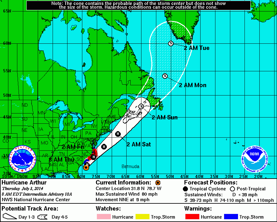
The Miami-based center’s 5 a.m. forecast update for Arthur, which upgraded the storm from a tropical storm to a hurricane, showed that the center of the storm was here, or 340 miles southwest of Cape Hatteras and 190 miles south-southwest of Cape Fear in North Carolina. Arthur’s winds were topping at 75 mph at that point.
By 2 p.m. Thursday, Hurricane Arthur is expected to reach 80 mph and move in a northeasterly direction. The National Hurricane Center forecasts Arthur to be here by that time, or about 60 miles east of Charleston, South Carolina.
Arthur is then forecast to continue to move to the northeast and reach closer to land around the Outer Banks around 2 a.m. Friday. The hurricane’s maximum winds are projected to be 85 mph, with gusts up to 105 mph.
Continuing to the northeast, Arthur is expected by 2 p.m. Friday to be here, or about 150 miles east of the Delaware and Maryland coasts. Winds will continue to be 85 mph with 105 mph gusts, according to the hurricane center’s forecast.
By early Saturday morning, Arthur will still be packing hurricane-force winds at 80 mph with gusts around 100 mph and be moving to the northeast, according to the forecast model. The projections put Arthur here at that time, or about 200 miles east of Providence, Rhode Island.
Arthur is forecast to weaken to tropical storm force winds as it heads toward Canada early Sunday morning. The storm will have winds of 60 mph and gusts of 70 mph and be around here, or about 50 miles southeast of Newfoundland.
© Copyright IBTimes 2024. All rights reserved.
-

Eiffel Tower Loses Sparkle For Parisians Ahead Of Olympics
-

Former Number One Momota Retires From International Badminton At 29
-

World Bank Aiming To Connect 250 Mn Africans To Energy Grid By 2030
-

IMF Says Global Debt Levels Face 'Great Election Year' Risk
-

Divisions Among Colombia's FARC Dissidents Complicate Peace Talks
-

French Far Right Gets Youthful Vibe With 28-year-old Leader
-

US Fed's Powell Says Inflation Fight May Take 'Longer Than Expected'
-

Mideast-related Oil Price Spike Threatens 'Relatively Good' Economic Outlook: IMF Chief Economist
-

Wine Growers 'On Tip Of Africa' Race To Adapt To Climate Change
-

Despite Olympic Truce, Games Wrestle With Political Fallout


