

Hurricane Irene 2011: Florida May Be Spared Direct Hit
Hurricane Irene may not hit Florida directly, according to updated path projections from the National Weather Service.
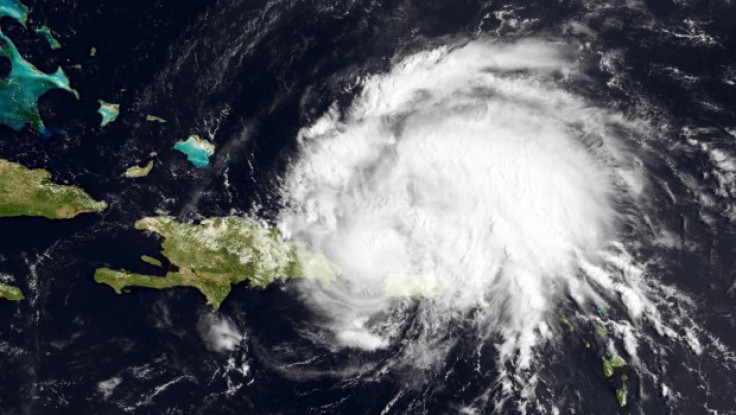
The storm -- which currently has sustained winds of about 80 mph but is expected to strengthen into a Category 3 hurricane with winds up to 115 mph -- was about 50 miles north of the Dominican Republic as of 2 p.m. Monday. The National Weather Service said it would most likely reach Florida by Thursday and Charleston, S.C., by Saturday.
If it keeps to the projected path, the hurricane would dump between 10 inches of rain on Puerto Rico, the Virgin Islands, Hispaniola and the Bahamas before passing about 100 to 150 miles east of the Florida coast.
However, Florida residents can't breathe easy just yet. Despite the eastward shifting, the system has the potential to be so strong and large that we could still see tropical storm conditions, meteorologist Pablo Santos of the National Weather Service said. All it would take would be a minor jog to the west, and that could bring tropical storm winds right over us.
Irene is the first hurricane of the 2011 Atlantic season. It reached hurricane status while passing over Puerto Rico at 5 a.m. Monday, leaving hundreds of thousands of people without power.
© Copyright IBTimes 2024. All rights reserved.
-

Bitcoin And Crypto Price Review - Another Myth Gets Busted?
-

Mass Cancellations Loom Despite French Air Union Cancelling Strike
-

Mired In Crisis, Boeing Reports Another Loss
-

Recycled 'Zombie' Misinformation Targets US Voters
-

Hackers Leak Part Of Source Code Of El Salvador's Bitcoin Wallet
-

Azerbaijan Says 'Closer Than Ever' To Armenia Peace Deal Amid Border Talks
-

How UK's Biggest Water Supplier Sank Into Crisis
-

Taiwan Hit By Dozens Of Strong Aftershocks From Deadly Quake
-

Gaza Health System 'Completely Obliterated': UN Expert
-

In Ecuadoran Amazon, Butterflies Provide A Gauge Of Climate Change


