

Hurricane Irene 2011: How to Track the Storm’s Path Online

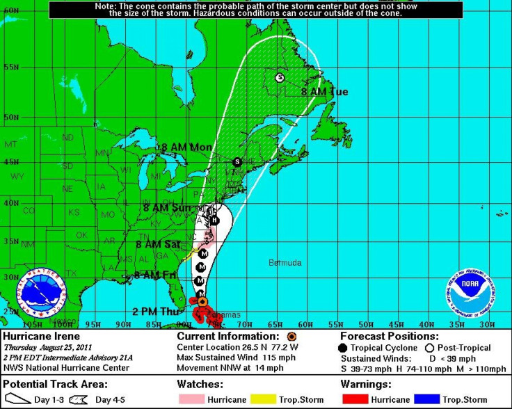
A major Category 3 storm, Hurricane Irene is on a path that leads right up the East Coast from the Carolinas up to New York and the New England States.
Forecasters at the National Hurricane Center (NHC) and officials at the Federal Emergency Management Agency (FEMA) have urged all residents along the Eastern Seaboard to stay alert and monitor the storm.
By Thursday afternoon, Irene had grown into a massive Category 3 tropical cyclone with hurricane-force-winds extending outward up to 70 miles from the storm center and tropical-storm-force winds extending a whopping 225 miles.
With such a large storm headed in the direction of millions of Americans, it is important to stay on top of Hurricane Irene. There are a plethora of sites for tracking the storm and several great apps for your iPhone and iPad that will help you keep abreast of the situation.
Here's the rundown of what's available on the web and on your phone.
Helpful Web sites to track the storm:
NOAA - National Oceanic and Atmospheric Administration
NOAA's National Hurricane Center is the organization responsible for producing the alerts throughout the day. It is predominately their information that other Web sites will be using to create their models. If you want to go right to the source, this is the site for you.
Stormpulse is a flashy Web site that offers several different ways to interact with an upcoming storm. Not only can you measure the distance from the eye of the storm to your nearest city, you can adjust the storm model to show the radar, cloud cover, watches and warnings, and the forecast models of several organizations. If you want all of the information aggregated to one place, this site may be the best.
NASA Earth Science Office
The Earth Science Office at NASA provides daily satellite images of hurricanes as they approach the U.S. coast. Go straight here to get a feel for the actual cloud cover and shape of the storm.
Weather Underground has many ways of tracking a storm, several of which are not found on other sites. Not only can you see the forecasts, models, track, and satellite, but you can track the storm's history from the beginning. Weather Underground is like an encyclopedia of storms past and arguably the best site for referencing a storm's history.
AccuWeather
AccuWeather presents the storm information in a slightly different way than other weather outlets, using models like wave and rain impacts and Risk to lives and Property this Week. Also, several meteorologists blog throughout the day to keep you informed. If you'd like to see how the storm could impact you locally, AccuWeather is a good place to reference.
Everything presented on the cable news network can be found here. The Weather Channel has reporters on the ground giving up to date information on local conditions. They provide great information specific to your region and produce several models to gauge the impact of the storm.
Ibiseye claims to bridge the gap between the technical world of meteorology and the common man. The site presents the information rather simply, overlaying satellite imagery on a flat map with the storm's track.
iPhone and iPad apps:
Hurricane and Hurricane HD by KittyCode - $2.99
This app is the most highly rated app for the iPhone and iPad. The app includes detailed interactive tracking maps, outlook and invest info, satellite and radar choices, as well as historical charts. All the information is presented in an easy, visually pleasing way to allow seamless switches between modes.
Hurricane Tracker by EZ Apps, Inc. - $2.99
Not really a native app per se, this program is a mashup of various web data from the National Hurricane Center and other sources. It includes personal push alerts, audio updates, in-depth video updates, and a live twitter feed.
Hurricane Track for iOS by Mach Software Design - Free
Hurricane Track provides eight live radars, hurricane paths, cloud formations, tropical weather summaries, discussions, and outlooks. The information is presented in a nice, easy to navigate format. Best of all, it's free!
Hurricane Station Lite by Purple Innovation - Free
While not the best hurricane tracker, this app makes up for it with a nice price: Free! The program is very basic, but may meet all your needs if you just want the general information.
NOAA Now by Neil Kelly - Free
NOAA Now provides the latest information from the National Oceanic and Atmospheric Administration. Basically, everything you see on the National Hurricane Center's Web site, you can find here. It's not a flashy app, but it provides all the essential charts and information.
Have any more suggestions on how to track the storm? Feel free to share in the comments.
© Copyright IBTimes 2024. All rights reserved.
-

Ukraine, Israel, TikTok: The Massive Aid Package Before US Congress
-

Eiffel Tower Loses Sparkle For Parisians Ahead Of Olympics
-

Former Number One Momota Retires From International Badminton At 29
-

Why Insurance Prices Have Skyrocketed
-

World Bank Aiming To Connect 250 Mn Africans To Energy Grid By 2030
-

IMF Says Global Debt Levels Face 'Great Election Year' Risk
-

Divisions Among Colombia's FARC Dissidents Complicate Peace Talks
-

French Far Right Gets Youthful Vibe With 28-year-old Leader
-

US Fed's Powell Says Inflation Fight May Take 'Longer Than Expected'
-

Mideast-related Oil Price Spike Threatens 'Relatively Good' Economic Outlook: IMF Chief Economist


