

Hurricane Irene: Dare County Orders Visitors to Evacuate as Hurricane Strengthens
North Carolina's Dare County on Wednesday told all visitors to evacuate Carolina as of 8 a.m. on Thursday to get out of the way of Hurricane Irene.
County officials issued a statement which said that residents should be prepared for a monster storm and that it is compulsory for nonresidents to leave the area with their personal belongings by Thursday morning.
The vulnerable Outer Banks, where Irene could make landfall is also included.
Although the mandatory evacuation order is for all Dare County visitors, residents are advised to take proper precautions and make general storm preparations. This effort should include securing all loose items outdoors. Monitor local news outlets for further advisories from the National Weather Service and state and local emergency management officials, the statement said.
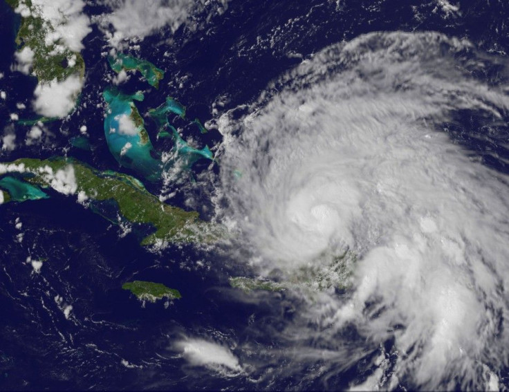
Hurricane Irene hit the southeastern Bahamas hard on Wednesday as a Category 3 storm, and could strengthen to a Category 4 storm by Thursday as it approaches the United States, the National Hurricane Center said.
The hurricane maintained wind speeds of 120 mph and force winds extending out 60 miles as it continued to move northward at about 12 mph.
The Hurricane Center on Wednesday urged people from the Carolinas northward through New England to monitor Irene's progress. It warned residents of an extremely dangerous storm surge over the Bahamas. The center also said that by Thursday Irene would begin affecting the southeastern U.S. coast.
The storm got very well organized as she passed farther away from the big island of Hispaniola, said Bill Read, Head of the National Oceanic and Atmospheric Administration's National Hurricane Center in Miami, during a briefing on Wednesday.
The effects of the hurricane in the form of tropical-storm, maybe even hurricane-force winds, rain, beach erosion, and tidal surge will be in play from the mid-Atlantic all the way up through New England as the storm progresses, he added.
As of 8:00 p.m. EDT, the storm center was located 185 miles southeast of Nassau, Bahamas, or about 810 miles south of Cape Hatteras, North Carolina, moving northwest at 12 mph.
Hurricane-force winds now extend outward up to 60 miles from the storm center with tropical storm-force winds extending up to 230 miles. That makes Irene slightly larger than earlier Wednesday.
A hurricane warning remains in effect for all of the Bahamas, while the National Hurricane Center made a broad warning to residents from the Carolinas northward to New England to monitor the progress of the storm.
© Copyright IBTimes 2024. All rights reserved.
-

Ukraine, Israel, TikTok: The Massive Aid Package Before US Congress
-

Eiffel Tower Loses Sparkle For Parisians Ahead Of Olympics
-

Former Number One Momota Retires From International Badminton At 29
-

Why Insurance Prices Have Skyrocketed
-

World Bank Aiming To Connect 250 Mn Africans To Energy Grid By 2030
-

IMF Says Global Debt Levels Face 'Great Election Year' Risk
-

Divisions Among Colombia's FARC Dissidents Complicate Peace Talks
-

French Far Right Gets Youthful Vibe With 28-year-old Leader
-

US Fed's Powell Says Inflation Fight May Take 'Longer Than Expected'
-

Mideast-related Oil Price Spike Threatens 'Relatively Good' Economic Outlook: IMF Chief Economist


