

Hurricane Irene Drenches Puerto Rico, Heads for Florida
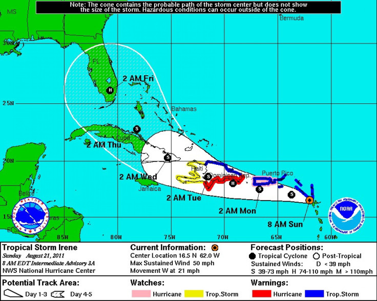
Hurricane Irene is only skirting the northern coast of Hispaniola on early Monday after striking Puerto Rico, but the storm is now heading toward the U.S. East Coast, where it could strike Florida Wednesday night and Thursday.
Forecasts show Hurricane Irene is likely to hit Florida as a Category 2 storm, possibly bringing heavy, damaging winds and rain through Saturday.
Early Monday morning, the storm was visible on radar at about 35 miles southeast of San Juan, moving west-northwest near 15 miles per hour with maximum sustained winds of 70 miles per hour -- the minimum level for a Category 1 storm.
Irene reached hurricane strength in the early hours on Monday morning after it began moving across Puerto Rico, pounding the Caribbean island with heavy rainfall and high winds. Forecasters had said Irene was likely to pass south of Puerto Rico, but the storm shifted north and instead went directly over the island.
At times early Monday, Irene's winds reached 75 miles per hour. In San Juan, the storm dumped as much as 8 to 10 inches of rain as people sought shelter.
You can hear the wind, the gusts are relentless, said 59-year-old Maria Antonia Ordonez, as she secured the shutters of her house in historic Old San Juan after inviting neighbors over for dinner and wine to wait out the storm, according to The Associated Press. I can't see anything because I've closed everything.
The island of Hispaniola --which is shared by the Dominican Republic and Haiti -- still has many people who live without shelter after last year's earthquake that decimated Haiti and the region.
In Puerto Rico, at least 120,000 people were left without power and another 13,000 without water as the storm approached on Sunday.
Now, all eyes are on Irene to see if the storm strengthens and makes a strike on the U.S. East Coast. Indications on Monday morning are that Irene will strengthen over the next five days, tracking toward Florida and the Southeast U.S. on Wednesday night, Thursday and into the weekend, most likely as a Category 2 storm with winds of 100 to 110 miles per hour.
The latest forecasting models show Irene making a direct assault in a most likely path entering near Miami and continuing a path straight up the center up the state, reaching Jacksonville by early Saturday morning. If Irene does take that path, the state will be inundated by high winds and heavy rainfall for two to three days, potentially causing severe damage.
Residents of Florida are encouraged to closely monitor weather reports and storm updates from now and through the weekend for possible evacuation notices.
© Copyright IBTimes 2024. All rights reserved.
-

Taiwan Hit By Dozens Of Strong Aftershocks From Deadly Quake
-

Gaza Health System 'Completely Obliterated': UN Expert
-

In Ecuadoran Amazon, Butterflies Provide A Gauge Of Climate Change
-

50 Years On, Vintage Vehicles To Reenact Portugal's Carnation Revolution
-

Conflicts Push Military Spending To 'All-time High': Report
-

'Thank You, America:' Zelensky And Netanyahu Applaud House Passage Of Foreign Aid Package
-

Women Journalists Bear The Brunt Of Cyberbullying
-
US Aid Shows Ukraine Will Not Be 'Second Afghanistan': Zelensky
-

Elon Musk's X Fights Australian Watchdog Over Church Stabbing Posts
-

Ukraine, Israel, TikTok: The Massive Aid Package Before US Congress


