

Hurricane Irene Path: Slams Bahamas, Heads to North Carolina, New York
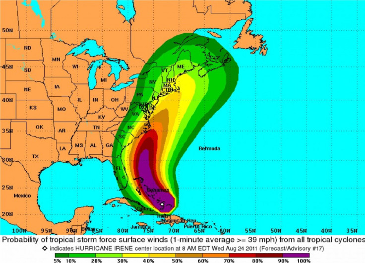
Hurricane Irene thrashed the Bahamas Wednesday, knocking down trees, tearing up roofs and posing the most severe threat to the smallest and least populated islands, and is now moving toward the North Carolina coast with sustained winds of 115 mph.
The hurricane could threaten the densely populated U.S. Northeast, including New York, by midday Saturday. New York City officials have begun preparations to evacuate residents from low-lying areas, if necessary.
Mandatory evacuation orders for parts of North Carolina's Outer Banks will take effect Thursday morning.
Starting at 8 a.m., tourists will be required to exit Dare County, North Carolina -- home to Manteo, Nags Head, Duck and Kitty Hawk. Residents can stay for now, but they are advised to gear up for Irene, according to CNN.
New York officials are preparing to shut down the city's subway stations and tunnels ahead of time to reduce damage to the infrastructure, as these places are most likely to be flooded. They asked residents to stock emergency supply kits at home, including bottled water, non-perishable food and a battery-powered radio.
Officials haven't decided whether to close beaches or limit access to the water to reduce risk. Emergency management officials will be available all weekend to avert risks of the dangerous storm.
The sense is that we're going to be facing a strong tropical storm with winds of 40 to 60 mph, said New York Emergency Management Commissioner Joseph F. Bruno.
Bruno added that the city's agencies were preparing for a worst-case scenario of a Category 1 hurricane with winds surpassing 72 mph and waters surging dangerously in low-lying areas, the Associated Press reported. Officials were readying to evacuate the most frail and needy from hospitals and nursing homes.
Evacuees will be able to avail public transport facilities before transit authorities cease operations, and they could use shelter on higher ground at dozens of city evacuation centers, Deputy Mayor for Operations Cas Holloway said. In the event that any kind of evacuation was needed we would be using every available communication means and working with people in the local community.
Irene pounded the central Bahamas early Thursday, whipping the island chain with gusts of up to 150 mph, a Hurricane Center advisory said.
The Bahamas' National Emergency Management Agency reported damages to a church roof on Mayaguana. The island has been without power since Tuesday. It said about 40 houses received damages that includes the communities of Betsy Bay, Pirate Wells and Abraham's Bay.
Bahamian Prime Minister Hubert Ingraham Tuesday spoke to the nation and said Irene was the third hurricane to threaten the entire archipelago since 1866. He urged them to take precautions.
Ingraham told the San Francisco Chronicle that there have been no major injuries or deaths, according to preliminary reports he has been receiving from all over the widely scattered islands.
But he added that they would not know the full extent of damage from the Category 3 storm until it is clear of the country on Friday. Irene has the potential to rise to a Category 4 hurricane by Thursday before its onslaught on the coast.
Government offices and banks closed early on Wednesday, giving people in Nassau and other parts of the Bahamas ample time to finish preparing for the storm and hunker down by late afternoon.
© Copyright IBTimes 2024. All rights reserved.
-

Australia's Great Barrier Reef Struggles To Survive
-

Alexandre De Moraes: Brazil Judge In Feud With Elon Musk
-

Paris 2024 Games Flame To Be Lit In Ancient Olympia
-

How The US Helped Counter Iran's Attack On Israel
-

How The Premier League Title Race Stands With Six Games To Go
-
In Haiti, Political Parties Lash Out At PM Over Council Limbo
-

Police Probe Killer's Targeting Of Women In Sydney Mall Attack
-

In Tehran, Fears Grow Of Potential Iran-Israel War
-

Stretched Valuations, Interest Rate Expectations, Make Stocks Vulnerable To Sell-offs
-

Funding Shortfall Threatens Internet Access For Millions Of Low-Income Americans


