

Hurricane Irene: Storm Watches Issued for Carolinas
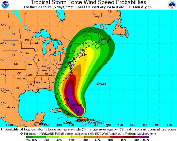
Hurricane and tropical storm watches were issued for the Carolinas early Thursday as Hurricane Irene moved over the northwestern Bahamas, the National Hurricane Center said.
A hurricane watch had been issued for the North Carolina coast from north of Surf City to the Virginia border, including the Pamlico, Albemarle and Currituck Sounds. A tropical storm watch had been issued from north of Edisto Beach, S.C., to Surf City.
At 5 a.m. EDT (0900 GMT), Irene was located about 735 miles south of Cape Hatteras, packing maximum sustained winds of 115 miles per hour (185 km/h).
Irene hit the southeastern Bahamas hard on Wednesday as a Category 3 storm, and could strengthen to a Category 4 storm by Thursday as it approaches the United States.
If it reaches Category 4 strength as expected on Thursday, the storm could carry a very high risk of injury or death to people, livestock and pets due to flying and falling debris, according to the National Weather Service.
The threat of such danger has jumpstarted preparation and evacuation efforts throughout the United States. Ocracoke Island, a tiny barrier island in North Carolina, has already asked residents to begin evacuating as it prepares for the biggest hurricane to hit American soil in seven years.
The last big hurricane of at least Category 3 strength to strike the U.S. was Hurricane Jeanne in 2004. The last hurricane to make landfall in the U.S. was Hurricane Ike, in 2008.
Not only has have the Carolinas begun to prepare, as possibly the expected first U.S. landing point for Irene, but states throughout the East Coast are gearing up for possible impact from the powerful hurricane.
Virginia state agencies are preparing for Irene in case it changes its path, according to its Department of Emergency Management.
The hurricane could graze Virginia on Saturday as it begins its path upwards towards the New York and New England areas. The expected heavy rainfall, high speed winds, and other effects led the Federal Emergency Management Agency to issue a warning to all residents of the East Coast.
Go ahead and make sure you're ready and then if evacuations are required, heed those evacuation orders, Craig Fugate, manager of FEMA, told ABC News. The Hurricane Center says this storm is going to grow and strengthen... and it's really something people need to be prepared now for so they can be ready if they have to act.
Northeast residents can expect remnants of the hurricane to hit New Jersey by Sunday afternoon, before it continues to make its way up to New York and New England, according to forecasters.
There's a lot of uncertainty with the track right now, said Al Cope, a meteorologist with the National Weather Service's Mount Holly office, to the Star Ledger. The center could be off the coast of New Jersey by Sunday afternoon.
From New Jersey, it could make landfall in New York by Sunday evening.
The exact center of the storm may actually stay pretty close to the coastline during the day on Saturday and then become a big threat for New England and perhaps Long Island on Sunday, Bill Read, director of the National Hurricane Center, told reporters.
The New England and Long Island areas have historically been remiss of hurricanes. According to the Weather Channel, only 10 hurricanes have come within 75 miles of Boston since 1851, with Hurricane Bob approaching the area in 1991.
The last hurricane to hit Long Island was Hurricane Gloria in 1985, but the area is preparing for Irene.
It looks like Long Island will be impacted in some way by this system, whether it's a hurricane or not when it gets here, said meteorologist Brian Ciemnecki of the National Weather Service to Newsday.
Potential Hurricane Damage
As Irene makes its way towards the United States, insurance companies look on with elevated concern over the potential damage that it could cause. A Category 4 hurricane could cause some serious damage, but the area that it occurs in factors most into economic impact.
It really depends on where it makes landfall, Chris Hackett, the Director for Personal Line Policy for the Property Casualty Insurers Association of America, told the IBTimes. If it makes landfall right in Miami where there are a lot of high-rise condominiums the damage will be a lot more expensive than if it hits a rural area in Georgia or in the Carolinas.
Hackett said that insurers are likely tracking the hurricane and following where scientists and meteorologists are predicting the hurricane will hit. Once insurers know impacted locations, they can send mobile catastrophe units to help people as soon as possible after a disaster.
Wherever it does hit, insurers definitely take it very seriously in trying to be as responsible to policy holders as they can be, he added.
© Copyright IBTimes 2024. All rights reserved.
-

Australia's Great Barrier Reef Struggles To Survive
-

Alexandre De Moraes: Brazil Judge In Feud With Elon Musk
-

Paris 2024 Games Flame To Be Lit In Ancient Olympia
-

How The US Helped Counter Iran's Attack On Israel
-

How The Premier League Title Race Stands With Six Games To Go
-

In Haiti, Political Parties Lash Out At PM Over Council Limbo
-

Police Probe Killer's Targeting Of Women In Sydney Mall Attack
-

In Tehran, Fears Grow Of Potential Iran-Israel War
-

Stretched Valuations, Interest Rate Expectations, Make Stocks Vulnerable To Sell-offs
-

Funding Shortfall Threatens Internet Access For Millions Of Low-Income Americans


