

Hurricane Irene Takes Aim at New York
One day after New York was shaken and rattled by an earthquake, forecast models show that Hurricane Irene has taken aim at America's largest metropolitan area. The latest forecast models show Irene could make landfall late Sunday at hurricane strength, packing winds of 80 miles per hour or more.
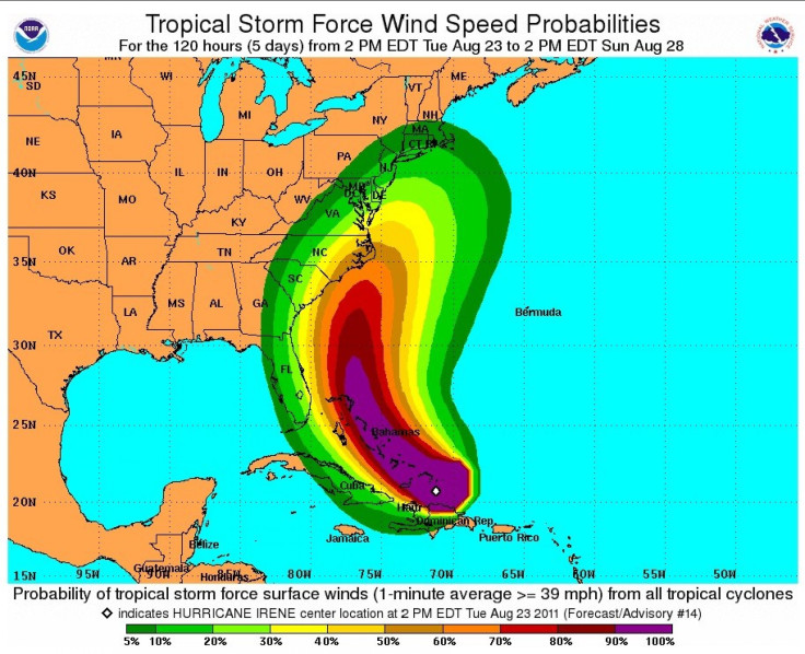
Hurricane Irene gained strength Tuesday night and is now a Category 3 storm on the Saffir-Simpson scale. The storm is projected to impact the U.S. East Coast beginning Friday and into the weekend, and already authorities are telling New York area residents to be on alert.
Early Wednesday, Hurricane Irene was upgraded to a Category 3 storm -- moving it into the major storm grouping.
The storm is likely to approach southeast Virginia Saturday night before moving just off the New Jersey shore Sunday. Hurricane Irene could make landfall on Long Island or in southeast New England late Sunday afternoon or Sunday night.
Heavy rain, pounding surf, rip currents and strong winds are expected along the the coast into New England as the storm approaches and passes.
This is a good time to get prepared again in your homes. There's items that you should stock up on, those that need to move or possibly be evacuated, perhaps seniors should think about having their medications refilled and having enough on hand, Nassau County, N.Y., Executive Ed Mangano told CBS New York.
On Tuesday, New Yorkers were shaken by an earthquake registering 5.8. A U.S. Geological Survey Geophysicist said an earthquake of this magnitude is rare for the East Coast. There are fault lines throughout the East Coast, but typically quakes in the region are shallow.
Thus, while it was a significant shake, damage from the quake was mostly confined to the epicenter, in the Virginia and Washington, D.C. areas.
I thought I was having a nervous attack, said one employee of a Manhattan cafe, explaining what the earthquake felt like Tuesday afternoon.
Irene has the potential to be a serious and multiple-hazard threat for New York and other highly-populated areas along the I-95 corridor. The potential for flooding rains, high winds, widespread power outages and down trees and power lines Sunday and into Monday is very high, authorities say.
Storm paths are always uncertain, but officials are already warning New York area residents to be on alert.
But before Irene reaches New York, the powerful and strengthening storm could wreak havoc as it makes its way up the East Coast. The threat level for the east coast of Florida has been decreased to low as it looks like the Sunshine State got off easy this time, as the storm plows toward the Carolinas.
Forecasts show Irene could clip the Outer Banks of North Carolina late Friday as a Catogory 3 storm packing maximum sustained winds of 120 miles per hour or greater.
© Copyright IBTimes 2024. All rights reserved.
-

French Air Traffic Controller Strike Threatens Flight Chaos
-

Azerbaijan Says 'Closer Than Ever' To Armenia Peace Deal Amid Border Talks
-

How UK's Biggest Water Supplier Sank Into Crisis
-

Taiwan Hit By Dozens Of Strong Aftershocks From Deadly Quake
-

Gaza Health System 'Completely Obliterated': UN Expert
-

In Ecuadoran Amazon, Butterflies Provide A Gauge Of Climate Change
-

50 Years On, Vintage Vehicles To Reenact Portugal's Carnation Revolution
-

Conflicts Push Military Spending To 'All-time High': Report
-

'Thank You, America:' Zelensky And Netanyahu Applaud House Passage Of Foreign Aid Package
-

Women Journalists Bear The Brunt Of Cyberbullying


