

Hurricane Irene Update: Storms Strengthens, Path Leading to U.S. Strike
Hurricane Irene has grown stronger, and the storm is expected to further strengthen and strike the U.S. southeast coast by the weekend, possibly as a Category 3 or Category 4 storm. More than 60 million people from Florida to New York and Massachusetts could be impacted by the powerful storm.
The U.S. National Hurricane Center's forecast indicates that Hurricane Irene, currently classified as a Category 2 storm with winds of 100 miles per hour, may become a powerful Category 3 storm, with maximum sustained winds exceeding 111 miles per hour, before it makes landfall somewhere along the southeast U.S. coast.
The first hurricane of the 2011 Atlantic season, Irene is big, intense and emerging as a serious threat to the U.S. mainland and a swath of densely populated areas. The U.S. hasn't had a direct hurricane strike since Ike struck Texas in 2008.
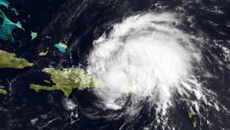
The storm's core was passing the Dominican Republic early Tuesday and will pass the southeastern Bahamas by late in the day Tuesday, forecasters said. Irene is moving to the west northwest at 10 miles per hour. Models suggest Irene might be a Category 4 storm with winds of 135 miles per hour by early Friday morning as it makes a glancing pass at sea up Florida's east coast.
But while Florida appeared in the path of a direct strike Monday, by Tuesday sharpened forecast models showed Irene is likely to move on up the U.S. east coast before striking directly in the Carolinas by late Saturday night or early Saturday morning. The storm is then likely to move on up the east coast, pounding high population coastal areas including New York and Massachusetts by late Sunday with high winds and heavy rains.
Florida remains on alert, however. Dennis Feltgen, a spokesman for the hurricane center, said Irene's projected path that parralels the Florida coast means that a wobble slightly to the left or a delay in an expected northward turn could place the storm's powerful core on the Sunshine state.
The stakes are high because it would take just a slight shift in the track to the left to make a dramatic change in the impact of the storm in a hugely populated area,'' he said in a statement.
© Copyright IBTimes 2024. All rights reserved.
-

Ukraine, Israel, TikTok: The Massive Aid Package Before US Congress
-

Eiffel Tower Loses Sparkle For Parisians Ahead Of Olympics
-

Former Number One Momota Retires From International Badminton At 29
-

Why Insurance Prices Have Skyrocketed
-

World Bank Aiming To Connect 250 Mn Africans To Energy Grid By 2030
-

IMF Says Global Debt Levels Face 'Great Election Year' Risk
-

Divisions Among Colombia's FARC Dissidents Complicate Peace Talks
-

French Far Right Gets Youthful Vibe With 28-year-old Leader
-

US Fed's Powell Says Inflation Fight May Take 'Longer Than Expected'
-

Mideast-related Oil Price Spike Threatens 'Relatively Good' Economic Outlook: IMF Chief Economist


