

Hurricane Katia Slightly Weakens Along Path, East Coast Could Feel Rip Currents [MAPS]

After strengthening into a major Category 4 storm on Monday, Hurricane Katia has since been downgraded a level on Tuesday as it moves northwest of the Caribbean. While there isn't any immediate threat to land, dangerous rip currents still remain the main hazard along the U.S. East Coast and Bermuda, forecasters said.
The National Hurricane Center expects that large swells generated by Katia will continue to affect the areas and will likely cause life-threatening surf and rip current conditions.
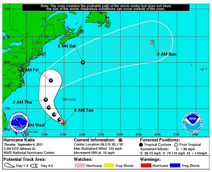
As of 11 a.m. Tuesday, Hurricane Katia was located about 400 miles (645 km) south of Bermuda, moving at 9 mph (15 km/h). The Category 3 hurricane is expected to continue this general motion through Wednesday, after which there could be a turn toward the north-northwest by Thursday.
Katia's maximum sustained winds have decreased to 120 mph (195 km/h). Hurricane force winds extend outwards up to 60 miles (100 km) from the center and tropical storm force winds extend outward up to 205 miles (335 km), according to the NHC.
Katia's beginning
Katia developed in the far eastern Atlantic on Aug. 29 as a tropical depression. From there it slowly strengthened into a hurricane, but dry air and shear caused the storm to weaken several times before the system quickly restrengthened into a Category 2 hurricane on Sunday, then a Category 4 hurricane on Monday.
Satellite images indicate that Katia has strengthened considerably during the past several hours, John Cangialosi, a hurricane specialist at the NHC, told Irish Weather Online. Fluctuations in the intensity of Katia are likely during the next 12 to 24 hours, perhaps due to eyewall replacement cycles, as the major hurricane remains in a favorable environment.
NHC forecasters expect slow weakening to begin on late Tuesday or early Wednesday, as Katia moves into an environment of moderate shear and slightly cooler waters.
But the dangerous rip currents remain the main hazard as Katia is forecast to stay far enough from land.
Large swells generated by Katia are expected to affect most of the East Coast of the United States, Bermuda, the Greater Antilles, and east-facing beaches of the Bahamas during the next few days, said Cangialosi. These swells are likely to cause life-threatening surf and rip current conditions. Swells affecting the northern Leeward Islands should continue to subside overnight.
Katia is the 11th named storm of the 2011 Atlantic hurricane season.
Weather officials have said they're expecting an above-normal hurricane season in the Atlantic this year - an outlook of about 14 to 19 named storms, with seven to 10 becoming hurricanes and three to five expected to become a major hurricane (Category 3 or higher), according to reports.
On average, the Atlantic hurricane season produces about 11 named storms, with six becoming hurricanes and two becoming major hurricanes.
The Atlantic hurricane season runs from June 1 through Nov. 30, with activities peaking in September.
© Copyright IBTimes 2024. All rights reserved.
-

IMF Says Global Debt Levels Face 'Great Election Year' Risk
-

Divisions Among Colombia's FARC Dissidents Complicate Peace Talks
-

French Far Right Gets Youthful Vibe With 28-year-old Leader
-

US Fed's Powell Says Inflation Fight May Take 'Longer Than Expected'
-

Mideast-related Oil Price Spike Threatens 'Relatively Good' Economic Outlook: IMF Chief Economist
-

Wine Growers 'On Tip Of Africa' Race To Adapt To Climate Change
-

Despite Olympic Truce, Games Wrestle With Political Fallout
-

What Will The Fed Do With The Latest Inflation Numbers?
-

US Retail Sales Up More Than Expected In March
-

Alexandre De Moraes: Brazil Judge In Feud With Elon Musk


