

Hurricane Raymond Expected To Strengthen As Category 3 Storm Moves Closer To Mexico [PHOTO]

Forecasters warned that Hurricane Raymond would possibly become stronger as the storm moved closer to the coast of Mexico.
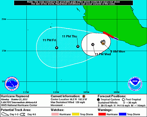
In its 8 a.m. update on Hurricane Raymond, the National Hurricane Center in Miami said Raymond was here, or about 115 miles south-southwest of Zihuatanejo, Mexico, and 165 miles west-southwest of Acapulco. Raymond has maximum sustained winds of 120 mph and is moving north at around 2 mph.
The NHC has issued a hurricane warning for a portion of the southwest Mexican coastline -- from Tecpan de Galeana to Lazaro Cardenas. A hurricane watch and a tropical storm warning are also in effect from Acapulco to Tecpan de Galenana.
Tropical storm conditions were expected to be experienced in the warning area later in the day on Monday, according to the NHC. Hurricane conditions were expected to hit the area by Monday night or early Tuesday. The center also said hurricane conditions are possible in the watch area by Monday night or Tuesday.
Hurricane Raymond is expected to produce about 2 to 4 inches of rain with as many as 8 inches over the Mexican states of Guerrero and Michoacan.
In discussing its 48-hour outlook for Hurricane Raymond, the NHC said the storm “is drifting northward at 2 mph. A continued northward drift is forecast and Raymond is expected to move closer to the coast of Mexico within the hurricane warning area later [Monday] and Tuesday.”
The Category 3 hurricane may strengthen “during the next day or so,” according to the hurricane center’s update. Hurricane-force winds extend 15 miles from the center of the storm and tropical storm-force winds extend up to 70 miles from Raymond’s center.
© Copyright IBTimes 2024. All rights reserved.
-

Eiffel Tower Loses Sparkle For Parisians Ahead Of Olympics
-

Former Number One Momota Retires From International Badminton At 29
-

Why Insurance Prices Have Skyrocketed
-

World Bank Aiming To Connect 250 Mn Africans To Energy Grid By 2030
-

IMF Says Global Debt Levels Face 'Great Election Year' Risk
-

Divisions Among Colombia's FARC Dissidents Complicate Peace Talks
-

French Far Right Gets Youthful Vibe With 28-year-old Leader
-

US Fed's Powell Says Inflation Fight May Take 'Longer Than Expected'
-

Mideast-related Oil Price Spike Threatens 'Relatively Good' Economic Outlook: IMF Chief Economist
-

Wine Growers 'On Tip Of Africa' Race To Adapt To Climate Change


