

Latest California Wildfire Map Shows Where Fires Are Still Burning

Firefighters continued working to contain multiple wildfires in Southern California Friday, almost two weeks after some of them began. A new map released by California's Department of Forestry and Fire Protection showed where the fires still burned.
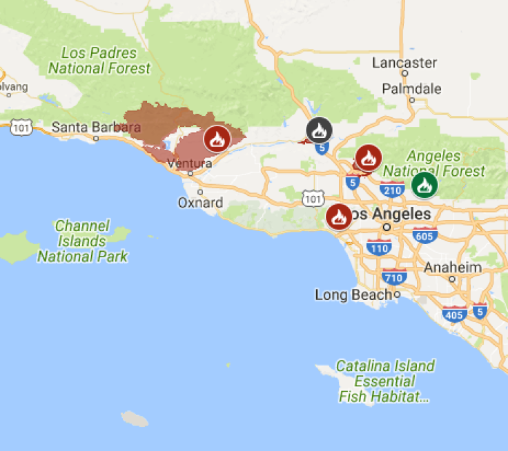
The largest of the fires, the Thomas Fire, consumed 252,500 acres by Friday morning, Cal Fire said. The fire was 35 percent contained and had already destroyed 972 structures and damaged another 218. Some 18,000 structures continued to be threatened by the blaze. After beginning in Ventura County Dec. 4, the fire encroached upon Santa Barbara County in recent days, threatening homes in Summerland, Montecito, Carpinteria and other surrounding areas.
More than 8,000 firefighters were on scene to help battle the Thomas Fire, utilizing more than 1,000 fire engines and 32 helicopters. Additional evacuation orders were issued for those threatened by the Thomas Fire, including in the area of Fillmore. Firefighters said they would focus their efforts on Santa Barbara County in the coming days where the fire was fiercest.
The Thomas Fire became the fourth largest in California history over the weekend, at a cost of more than $82 million so far. One firefighter, A Cal Fire engineer from the agency’s San Diego division, died as a result of the fire, according to a press release. Thirty-two-year-old Cory Iverson was killed while fighting the fire’s east flank in Fillmore, according to KTLA.
Fires elsewhere in the southern portion of California were mostly contained. The Skirball Fire, which broke out Dec. 6, burned through some 422 acres but was 90 percent contained Friday. The fire destroyed 12 structures and damaged an additional six. Three firefighters suffered minor injuries while on the scene.
The Creek Fire near Sylmar was 98 percent contained Friday but had already burned through more than 15,000 acres. Crews remained on scene to reinforce containment and continue suppression efforts, officials said. The Lilac Fire was also 98 percent contained Friday, Cal Fire announced. More than 4,100 acres of land were burned by the fire, while 157 structures were destroyed. Mandatory evacuation orders for the area surrounding the Lilac Fire were lifted, while all roads in the region were reopened.
In addition to those already burning for some time, a new wildfire broke out in Santa Barbara County Thursday afternoon. The Coast Fire started near San Julian Road, south of Lompoc, according to Santa Barbara County Fire public information officer Mike Eliason. The Coast Fire burned through about 13.6 acres and was about 30 percent contained Thursday evening, Eliason said. Full containment was expected to be reached shortly.
Forecasts said strong Santa Ana winds would continue throughout Friday and into the weekend, while gusts in high territories could reach up to 30 mph, according to the National Weather Service.
“It’s gonna be a very challenging few days,” said fire behavior analyst Tim Chavez, according to CNN.

© Copyright IBTimes 2024. All rights reserved.
-

Ukraine, Israel, TikTok: The Massive Aid Package Before US Congress
-

Eiffel Tower Loses Sparkle For Parisians Ahead Of Olympics
-

Former Number One Momota Retires From International Badminton At 29
-

Why Insurance Prices Have Skyrocketed
-

World Bank Aiming To Connect 250 Mn Africans To Energy Grid By 2030
-

IMF Says Global Debt Levels Face 'Great Election Year' Risk
-

Divisions Among Colombia's FARC Dissidents Complicate Peace Talks
-

French Far Right Gets Youthful Vibe With 28-year-old Leader
-

US Fed's Powell Says Inflation Fight May Take 'Longer Than Expected'
-

Mideast-related Oil Price Spike Threatens 'Relatively Good' Economic Outlook: IMF Chief Economist


