

Massive Earthquake Hits Solomon Islands, Papua New Guinea; Tsunami Warning Issued

UPDATE 10:55 p.m. EDT: The tsunami warning for Papua New Guinea has been lifted. The Pacific Tsunami Warning Center said late Sunday all threat of a destructive wave "has now mostly passed."
Original post
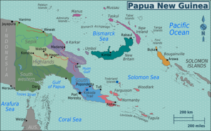
The Pacific Tsunami Warning Center Sunday issued a warning for the South Pacific Sunday following a massive 7.7 magnitude earthquake that rocked the Solomon Islands and Papua New Guinea. The quake hit at 7:48 p.m. EDT, 34 miles southeast of Kokopo, Papua New Guinea, the U.S. Geological Survey (USGS) reported.
The tsunami warning center said hazardous tsunami waves were possible within 1,000 kilometers (620 miles) of the epicenter, along the coasts of Papua New Guinea and the Solomon Islands, but there was no threat Pacific-wide.
USGS said the quake was centered near the town of Rabaul in northeast Papua New Guinea. The tsunami warning center said there was no threat to Hawaii, and the Wellington Dominion Post said New Zealand civil defense officials expected no threat to New Zealand.
A 6.3 magnitude temblor hit Papua New Guinea March 15. No damage or casualties were reported. That quake also was in the Rabaul area on the northeast tip of New Britain island, Reuters reported. A day earlier, a 5.3 magnitude quake rocked the Vanimo area.
The area of the quake is known as the Australia-Pacific plate and is more than 4,000 kilometers (2,500 miles) long. The Australian plate meets the Pacific plate along the South Solomon trench. There have been 13 earthquakes measuring at least 7.5 in the area since 1900. An 8.1-magnitude quake occurred April 1, 2007, on the western edge of the trench, spawned a tsunami that killed at least 40 people. It was the third quake of that strength in the past century.
© Copyright IBTimes 2024. All rights reserved.
-

IMF Says Global Debt Levels Face 'Great Election Year' Risk
-

Divisions Among Colombia's FARC Dissidents Complicate Peace Talks
-

French Far Right Gets Youthful Vibe With 28-year-old Leader
-

US Fed's Powell Says Inflation Fight May Take 'Longer Than Expected'
-

Mideast-related Oil Price Spike Threatens 'Relatively Good' Economic Outlook: IMF Chief Economist
-

Wine Growers 'On Tip Of Africa' Race To Adapt To Climate Change
-

Despite Olympic Truce, Games Wrestle With Political Fallout
-

What Will The Fed Do With The Latest Inflation Numbers?
-

US Retail Sales Up More Than Expected In March
-

Alexandre De Moraes: Brazil Judge In Feud With Elon Musk


