

Missing Flight MH370 Search Reveals Mysteries Of Deep Ocean

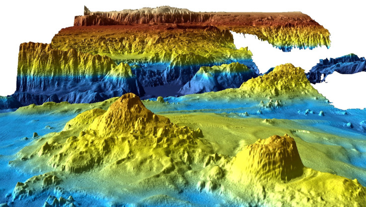
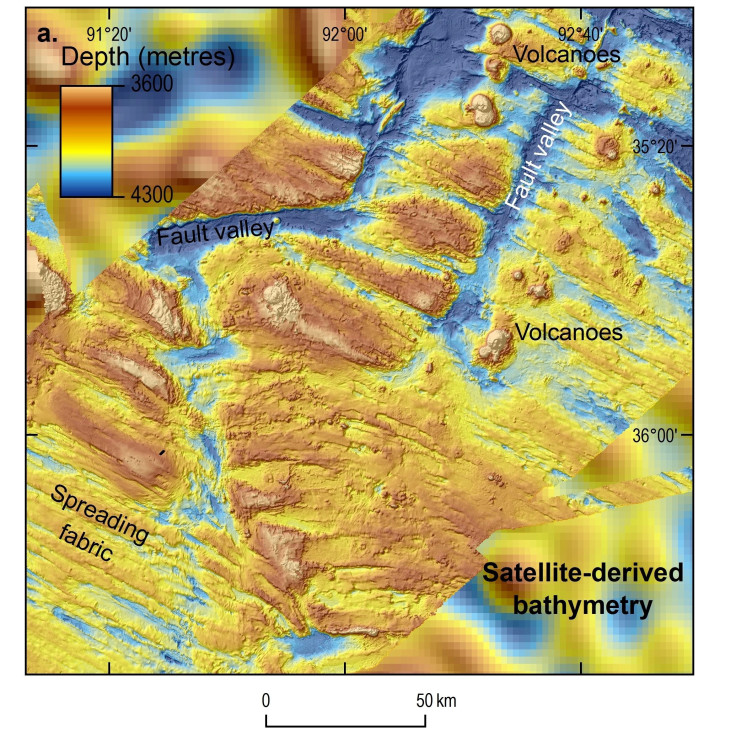
The search for missing Malaysian Airlines flight MH370 didn’t yield definitive answers about what happened to the plane — but it did reveal some of the deep ocean’s best-kept secrets. The hunt for the Boeing 777 uncovered volcanoes, massive underwater ridges and the plummeting depths of the Southern Indian Ocean’s valleys, according to maps released this week by Australia.
Thanks in part to the massive nature of the search and the fact that it was the most expensive of its kind, the hunt yielded never-before seen data. The information collected during the search was compiled into detailed maps of the sea floor — maps that scientists are hopeful will be useful in future ocean research.
Read: MH370 Went Into ‘Spiral Dive’ Before Crash, Previously Secret Data Says
“It is estimated that only 10 to 15 percent of the world’s oceans have been surveyed with the kind of technology used in the search for MH370,” Geoscience Australia’s environmental geoscience chief Stuart Minchin said Wednesday, according to AFP news. “[That] makes this remote part of the Indian Ocean among the most thoroughly mapped regions of the deep ocean on the planet.”

The search for the missing airliner encompassed a zone of about 46,000 square miles and revealed ridges almost four miles wide, valleys almost 4,000 feet deep and at least two shipwrecks. An additional set of data was scheduled to be released in 2018.
“This data is unique both because of the remote location of the search area and because of the sheer scale of the area surveyed,” said Minchin.
The search for the Boeing 777 was launched by multiple countries after it vanished in March 2014 on its way from Kuala Lumpur to Beijing with 39 passengers on board. The hunt continued for almost three years before it was officially halted by Malaysian authorities in 2017.
Despite the massive scope of the search, only a few pieces of the airliner were ever recovered, including a single fragment of the plane’s wing found on Reunion Island off the coast of Africa in 2015. Australian authorities, who spearheaded the search, said it’s possible the search could continue in the future if concrete evidence about its location was uncovered.
Read: Missing Flight Details From MH370 Won’t Be Released
“We remain hopeful that new information will come to light and that at some point in the future the aircraft will be located,” Australia’s Transport Minister Darren Chester said.
What, exactly, happened to the plane in its final moments remains unclear. Conspiracy theories abound, but a team of aviation experts concluded early in July that the aircraft was likely in a “spiral dive” in the moments just before it crashed and said there was probably nobody in control of the plane. The findings confirmed the Australian Transport Safety Bureau’s previous conclusion about the plane’s fate.
© Copyright IBTimes 2024. All rights reserved.
-

How The US Helped Counter Iran's Attack On Israel
-

How The Premier League Title Race Stands With Six Games To Go
-

In Haiti, Political Parties Lash Out At PM Over Council Limbo
-

Police Probe Killer's Targeting Of Women In Sydney Mall Attack
-

In Tehran, Fears Grow Of Potential Iran-Israel War
-

Asia-Pacific Gets New Weapon In Fight Against Drug-resistant TB
-

Ohtani Translator Case Shines Light On Insatiable Gambler
-
Fewer Showers, Less Laundry, As Water Cuts Hit Bogota
-

Stretched Valuations, Interest Rate Expectations, Make Stocks Vulnerable To Sell-offs
-

Funding Shortfall Threatens Internet Access For Millions Of Low-Income Americans


