

NASA Captures Calm Skies Over The Atlantic, Pacific And Indian Oceans [PHOTO]

NASA captured a rare occurrence on Sept. 8 as the skies over the Atlantic, Pacific and Indian oceans were calm despite the Northern Hemisphere being in the middle of hurricane season.
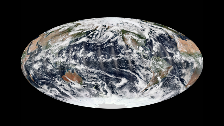
This composite image of Earth was created from 14 satellite passes, notes NASA. The images were collected by the Visible Infrared Imaging Radiometer Suite aboard the Suomi National Polar-orbiting Partnership (Suomi NPP) satellite. With the Atlantic and Pacific hurricane seasons lasting until November, the image is striking as there is no evidence of a hurricane, tropical storm or cyclone in any of three ocean areas.
NASA points out several smaller weather systems, such as the end of Tropical Storm Lorena or the tropical depression in the Atlantic, off the coast of the islands that make up Cape Verde. As NASA points out, the image was taken a day prior to the formation of tropical storm Humberto, which would become a hurricane on Sept. 11.
To date, the 2013 Atlantic hurricane season has produced nine named tropical storms and the National Hurricane Center predicted the possibility the season could be more active than normal, with 13 to 20 potential named storms and seven to 11 hurricanes, notes NASA. Despite the lack of hurricanes in the month of August, the second half of hurricane season tends to be more active. Gerry Bell, lead seasonal hurricane forecaster for the National Oceanic and Atmospheric Administration, said, “What happens in the early part of the season is generally not a good predictor of the second half of the season, which is when the majority of hurricanes and major hurricanes form,” reports NASA. Hurricane Ingrid quickly followed Humberto, and the 2013 Atlantic hurricane season ends in November.
© Copyright IBTimes 2024. All rights reserved.
-

Taiwan Hit By Dozens Of Strong Aftershocks From Deadly Quake
-

Gaza Health System 'Completely Obliterated': UN Expert
-

In Ecuadoran Amazon, Butterflies Provide A Gauge Of Climate Change
-

50 Years On, Vintage Vehicles To Reenact Portugal's Carnation Revolution
-

Conflicts Push Military Spending To 'All-time High': Report
-

'Thank You, America:' Zelensky And Netanyahu Applaud House Passage Of Foreign Aid Package
-

Women Journalists Bear The Brunt Of Cyberbullying
-
US Aid Shows Ukraine Will Not Be 'Second Afghanistan': Zelensky
-

Elon Musk's X Fights Australian Watchdog Over Church Stabbing Posts
-

Ukraine, Israel, TikTok: The Massive Aid Package Before US Congress


