

NASA's Mars Reconnaissance Orbiter Snaps Photo Of Recurring Slope Lineae On Slopes Of Valles Marineris

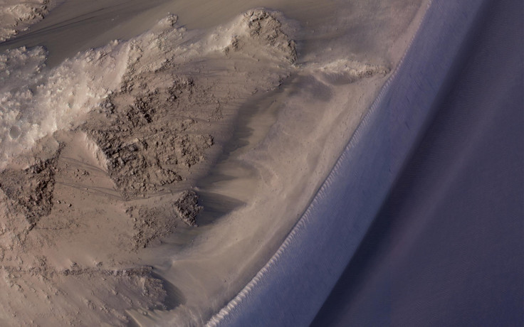
NASA’s Mars Reconnaissance Orbiter has snapped a stunning image of structures known as recurring slope lineae (RSL) in the slopes of the Valles Marineris canyon system located near Mars’ equator. The image, snapped using the MRO’s HiRise camera, shows several RSL that appear as dark lines extending downslope.
“Here, the RSL are active on east-facing slopes, extending from bouldery terrain and terminating on fans. Perhaps the fans themselves built up over time from the seasonal flows,” NASA said in a statement accompanying the image. “Part of the fans with abundant RSL are dark, while the downhill portion of the fans are bright.”
Read: Mars’ ‘Recurring Slope Lineae’ Continue To Puzzle Scientists
The presence of RSL on Mars was first announced in 2015, when NASA called the discovery the strongest evidence yet that liquid water still flows — or at least seeps — intermittently on the red planet.
However, since then, several studies have cast doubts over whether water really plays a role in the formation of RSL.
A study published last July, in which scientists examined thousands of RSL in 41 sites in the central and eastern portions of Valles Marineris, concluded that in some cases, water pulled from the atmosphere by salts, or mechanisms with no flowing water, may explain the presence of the RSL.
The authors of the study argued that it is highly unlikely for underground water to create the RSL in the canyon ridges and isolated peaks of Valles Marineris — where a lot of these streaks have been observed. On the other hand, if it is salts that are pulling water from the atmosphere, they would have to extract 10 to 40 Olympic-size swimming pools worth of water each year — something that is a near impossibility.
“The role of water in RSL activity is a matter of active debate,” NASA said in its statement.
Even if the RSL were not created by the action of water, it does not prove that water does not exist on the red planet — a lot of it could still be trapped below the surface, maybe in the form of a vast, frozen underground lake.
Data previously collected by the MRO and Curiosity has bolstered the theory that roughly 4.3 billion years ago, Mars had enough water to cover its entire surface in a liquid layer about 450 feet deep. Evidence also suggests that long after solar winds stripped the red planet of its atmosphere, turning it into the cold, arid world it is today, lakes of water and snowmelt-fed streams still existed on its surface.
Some studies have even suggested that about 3.8 billion years ago, Mars had enough liquid water to form an ocean occupying almost half of its northern hemisphere.
The MRO has been orbiting the red planet since 2006, and has beamed back striking photos of Mars to Earth every month. Last August, NASA published its largest dump of images captured by the MRO’s HiRise camera, releasing a cache of over 1,000 photos that show the Martian surface in all its glory — from dunes and craters to mountains and ice caps.
The entire collection of images captured so far by the HiRise camera can be viewed here.
© Copyright IBTimes 2024. All rights reserved.
-

Ukraine, Israel, TikTok: The Massive Aid Package Before US Congress
-

Eiffel Tower Loses Sparkle For Parisians Ahead Of Olympics
-

Former Number One Momota Retires From International Badminton At 29
-

Why Insurance Prices Have Skyrocketed
-

World Bank Aiming To Connect 250 Mn Africans To Energy Grid By 2030
-

IMF Says Global Debt Levels Face 'Great Election Year' Risk
-

Divisions Among Colombia's FARC Dissidents Complicate Peace Talks
-

French Far Right Gets Youthful Vibe With 28-year-old Leader
-

US Fed's Powell Says Inflation Fight May Take 'Longer Than Expected'
-

Mideast-related Oil Price Spike Threatens 'Relatively Good' Economic Outlook: IMF Chief Economist


