

New Orleans Levees Holding as Tropical Storm Lee Bears Down on Coast
Tropical Storm Lee is moving at a crawl, slowly slipping onto southern Louisiana's coast Sunday morning as New Orleans hunkers down in heavy rainfall, hoping levees that breached in Hurricane Katrina in 2005 hold. So far, levees are holding, but heavy rain continues.
New Orleans' levees have undergone a $1 billion upgrade after Hurricane Katrina.
The National Hurricane Center said Lee's center is about 125 miles west-southwest of New Orleans Sunday morning, with maximum sustained winds of 45 miles per hour at around 8 a.m. EDT.
Winds are gradually weakening from the storm, but that's the least of the threat from Lee. Up to 20 inches of rain is expected in the low-lying New Orleans area by the time the storm departs, and tornadoes has been spawned from the storm and that threat remains high also.
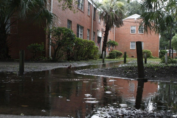
Half of New Orleans lies below sea level. Levees and flood gates protect the city, and it's those levees that breached during Hurricane Katrina in 2005 when 15 inches of rain fell, combined with storm surge that pushed into Lake Pontchartrain. The levees can process about one inch of rainfall per hour, making Tropical Storm Lee's slow-moving approach a major concern.
The slower the storm moves, the more rain it dumps on the city and region.
Early Sunday morning the levees were working and flooding in the area was minor but more rain is in the forecast for the next 24 hours for New Orleans.
On Saturday, Mayor Mitch Landrieu said stormy conditions could continue for the next 36 hours. Don't go to sleep on this storm, he told residents.
At 9:30 a.m. EDT Sunday, New Orleans was experiencing gusting winds from 21 to 31 miles per hour and thunderstorms. Heavy rain with possible flash flooding is expected in the area until Sunday afternoon. Rain will continue tonight and into Labor Day, but rainfall amounts will lighten as Lee plods north into Mississippi, Alabama and Tennessee, before dampening the Appalachian region.
Sunday morning a tornado warning was issued for Belle Chasse, La., in northwestern Plaquemines Parish but no reports of damage have been received yet. Also, areas of the Louisiana coast are experiencing 3 to 5 feet of water levels above ground level as the storm pushes ashore. Areas along the Mississippi and Alabama coasts, including Mobile Bay, are seeing water levels rise 1 to 3 feet.
Unlike many tropical cyclones, the focus with Tropical Storm Lee isn't the center of the storm. It's the girth of widespread, continual rain that worries forecasters.
In this case it's not so important to focus on the center. The center is on the coast and it's going to be moving inland in the next several hours, Todd Kimberlin with the National Hurricane Center told ABC. In this case all the front winds are well removed from the center.
Thousands in Louisiana and Mississippi have lost power from the storm, and Louisiana bayou towns have been evacuated. Also, a state of emergency has been declared in coastal parishes in Louisiana and coastal counties in Mississippi.
Lee is expected to spread rains north and east across portions of the South Sunday, while Monday heavy rain will spread into the Tennessee Valley and Appalachian regions. Lee is expected to be located on the Mississippi-Alabama border early Tuesday morning, so that region along with the Florida panhandle is expected to get heavy rains.
© Copyright IBTimes 2024. All rights reserved.
-

Ukraine, Israel, TikTok: The Massive Aid Package Before US Congress
-

Eiffel Tower Loses Sparkle For Parisians Ahead Of Olympics
-

Former Number One Momota Retires From International Badminton At 29
-

Why Insurance Prices Have Skyrocketed
-

World Bank Aiming To Connect 250 Mn Africans To Energy Grid By 2030
-

IMF Says Global Debt Levels Face 'Great Election Year' Risk
-

Divisions Among Colombia's FARC Dissidents Complicate Peace Talks
-

French Far Right Gets Youthful Vibe With 28-year-old Leader
-

US Fed's Powell Says Inflation Fight May Take 'Longer Than Expected'
-

Mideast-related Oil Price Spike Threatens 'Relatively Good' Economic Outlook: IMF Chief Economist


