

Operation IceBridge: NASA Measuring Melting Arctic Sea Ice By Plane
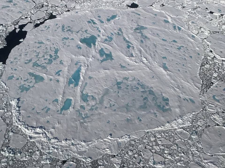
Rapid sea ice melt in the Arctic and record low wintertime extents have prompted NASA to fly over the sea ice north of Greenland to observe the impact of melt on the oldest and thickest ice in the Arctic. The observations are part of Operation IceBridge, aerial observation of Arctic sea ice conducted by NASA via plane.
The aircraft NASA is using to monitor the ice and melt ponds on the ice is equipped with a laser that can measure the changes in ice elevation as well as a high-resolution to map the ice and two experimental instruments.
Read: Climate Change Facts: Polar Bears Spending More Time Combating Drifting Sea Ice
The campaign to study the Arctic sea ice launched on July 17 from Greenland and was expected to consist of six flights that last about four hours each to survey ice that had lasted at least one summer. That multi-layer ice pack has shrunk over the past several decades. In the mid-80s, 70 percent of total winter Arctic sea ice extent was made up of this multiyear ice pack. In contrast, by 2012 less than 20 percent of the ice was made up of that type of long-lasting ice, according to NASA.
From today's #IceBridge flight: A sea ice floe with significant algae discoloration surrounded by many broken floes. pic.twitter.com/aioiKiRxBn
— NASA Ice (@NASA_ICE) July 24, 2017
That ice used to last through the year and would reflect back sunlight that reached it. As it’s melted that area of the world has become less reflective and now the ocean is exposed, which actually absorbs the sun’s energy instead of reflecting it. Then as the water warms, it melts the ice even further and the cycle continues, says NASA.
The flights will cover areas that IceBridge tracked during the springtime as well using similar methods to measure ice and melt to see what changes have occurred during the last couple months. That ice has drifted since then, movement that NASA has tracked using satellites.
Read: Global Climate Change: 2017 Second Warmest Year Since 1880
Researchers on the flights will also be using upgraded technology called the “Airborne Topographic Mapper” a laser altimeter that can transmit 10,000 pulses every second. The upgraded laser will more accurately measure elevation and could potentially offer new uses for ice and land. The laser will be experimentally used to measure the depth of meltwater lakes that form on the Greenland ice sheet during the summer melt months.
The amount of water the lakes hold are important to measuring melt, but current measurements taken from space are uncertain. The laser would offer more precise measurements of the lakes and a safer way to measure than getting too close to the unpredictable lakes in person.
NASA airborne research flights can be tracked online if you want to follow along with the progress of the mission. The data collected during the missions will take weeks to months to sort through but will offer updates to NASA’s mapping of sea ice.
© Copyright IBTimes 2024. All rights reserved.
-

Eiffel Tower Loses Sparkle For Parisians Ahead Of Olympics
-

Former Number One Momota Retires From International Badminton At 29
-

Why Insurance Prices Have Skyrocketed
-

World Bank Aiming To Connect 250 Mn Africans To Energy Grid By 2030
-

IMF Says Global Debt Levels Face 'Great Election Year' Risk
-

Divisions Among Colombia's FARC Dissidents Complicate Peace Talks
-

French Far Right Gets Youthful Vibe With 28-year-old Leader
-

US Fed's Powell Says Inflation Fight May Take 'Longer Than Expected'
-

Mideast-related Oil Price Spike Threatens 'Relatively Good' Economic Outlook: IMF Chief Economist
-

Wine Growers 'On Tip Of Africa' Race To Adapt To Climate Change


