

Peru Earthquake: 5.6, 4.6 Magnitude Quake Hit Capital Tuesday, No Injuries Reported

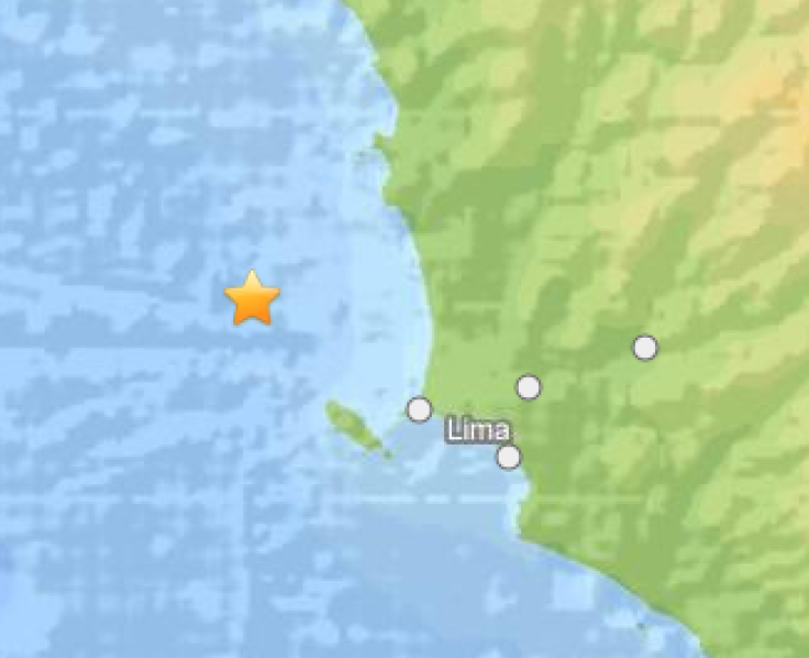
Peru’s capital of Lima was struck by an earthquake Tuesday afternoon and the U.S. Geological Survey said it measured 4.6 on the Richter scale. Initial reports from Peru’s own geological survey recorded a 5.6 magnitude quake. Officials told Reuters no injuries or damages were reported as of Tuesday afternoon.
The quake, which struck 21 miles west of Lima around 1:40 p.m., was centered in the Pacific Ocean, the U.S. Geological Survey said. Nearby cities including San Isidro, Chancay, Santa Maria and Callao, all within a maximum of 29 miles of the original site, likely felt the quake, its report said.
Last month, Peru’s Geological Mining and Metallurgical Institute said 92 areas in Lima were considered at risk of experiencing an earthquake following a 2012 report that estimated an 8-degree quake near the capital could cause more than 51,000 fatalities.
English-language site Peru This Week said the institute's president and Peruvian politician Susana Vilca advised officials to plan for future disasters in the potentially affected regions. Vilca called the 92 at-risk areas a “geologic and geohydrologic danger,” noting homes are built on sandy land.
The report said the areas considered most at-risk of experiencing future natural disasters includes Punta Hermosa, Lurín, Villa El Salvador, Pachacamác, Villa María del Triunfo, San Juan de Miraflores, Ate Vitarte, Lurigrancho-Chosica, Downtown Lima, Rímac, Ventanilla- Callao, Independencia, Comas, Carabayllo and Ancón.
© Copyright IBTimes 2024. All rights reserved.
-

Ukraine, Israel, TikTok: The Massive Aid Package Before US Congress
-

Eiffel Tower Loses Sparkle For Parisians Ahead Of Olympics
-

Former Number One Momota Retires From International Badminton At 29
-

Why Insurance Prices Have Skyrocketed
-

World Bank Aiming To Connect 250 Mn Africans To Energy Grid By 2030
-

IMF Says Global Debt Levels Face 'Great Election Year' Risk
-

Divisions Among Colombia's FARC Dissidents Complicate Peace Talks
-

French Far Right Gets Youthful Vibe With 28-year-old Leader
-

US Fed's Powell Says Inflation Fight May Take 'Longer Than Expected'
-

Mideast-related Oil Price Spike Threatens 'Relatively Good' Economic Outlook: IMF Chief Economist


