

Polar Vortex 2? Sort Of - But New Blast Of Winter Weather Expected To Be Gentler
Another blast of cold weather is bearing down on the Midwest and East Coast, but this one is expected to be a little gentler than the last one.
“Like many sequels, ‘The Return of the Polar Vortex’ will not be as impressive as the original, with temperatures averaging about ten degrees warmer than during the original Polar Vortex episode earlier this January,” Weather Underground meteorologist Jeff Masters wrote on Tuesday.
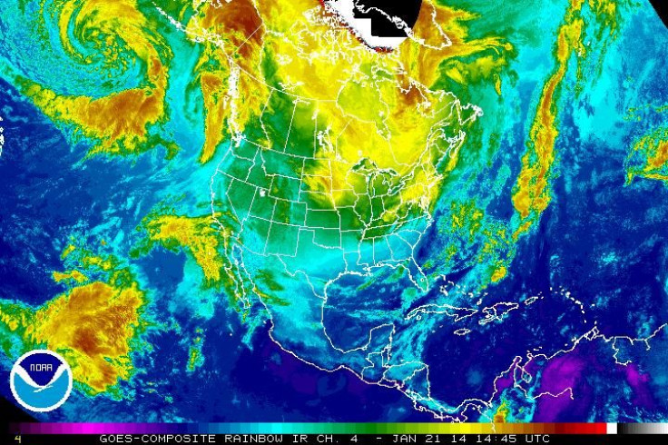
Even if it fails to match the frigid lows set by the previous storm, this new blast of cold air and snow -- dubbed Winter Storm Janus by the Weather Channel, which is continuing its practice of naming winter storms ever since the 2012-2013 season -- should supply plenty of powder. According to the National Weather Service, via radio station WBUR, the greater Boston area could see as much as 10 inches of snow by Wednesday morning, and 14 inches could fall on Cape Cod. New York City is bracing for what could be the largest snowfall so far this winter -- anywhere from 8 to 14 inches. In Chicago, snow accumulation had reached as high as 7 inches in some places by Tuesday morning. Nearly 2,000 U.S. flights were canceled by early Tuesday, according to Reuters.
Many places in the Midwest are feeling a big chill (though not quite as big as earlier this month). Areas in Michigan, Minnesota and Wisconsin saw temperatures below -20 degrees Fahrenheit on Tuesday morning, according to Masters -- with one of the lowest mercury readings coming from Crane Lake, Minn., at -32 degrees.
Meanwhile, many meteorologists think that maybe we should all be more careful about throwing around the term “polar vortex.”
A lot of the news coverage of the bitter cold felt across North America in early January may have misled you into thinking that the polar vortex was some Arctic cyclone-slash-ice tornado sweeping across the Midwest and New England. But that’s not quite the case, as the Weather Channel explained on Tuesday.
“The actual center of the Northern Hemisphere polar vortex never really moves through the atmosphere above the United States -- rather, it remains anchored farther to the north,” TWC meteorologists Chris Dolce and Nick Wiltgen wrote. “With that said, the counterclockwise flow around the polar vortex will help to shove cold air southward from the Arctic into the Lower 48 just like we see in many other winters. Think of it as a spoke of the polar vortex rotating through, ushering in the chilly temperatures.”
It’s interesting that the term “polar vortex” has experienced a sudden pre-eminence, since weather researchers have been using the term since at least the 1930s. And, as we explained during the first round of bone-chilling temperatures this month, the existence of the polar vortex does not disprove the concept of climate change or global warming.
“A polar vortex is not only not something new or mysterious,” Weather Underground meteorologist Stu Ostro wrote earlier in January. “It's a standard feature of the atmosphere, strongest in winter.”
© Copyright IBTimes 2024. All rights reserved.
-
French Air Traffic Controller Strike Threatens Flight Chaos
-

Azerbaijan Says 'Closer Than Ever' To Armenia Peace Deal Amid Border Talks
-

How UK's Biggest Water Supplier Sank Into Crisis
-

Taiwan Hit By Dozens Of Strong Aftershocks From Deadly Quake
-

Gaza Health System 'Completely Obliterated': UN Expert
-

In Ecuadoran Amazon, Butterflies Provide A Gauge Of Climate Change
-

50 Years On, Vintage Vehicles To Reenact Portugal's Carnation Revolution
-

Conflicts Push Military Spending To 'All-time High': Report
-

'Thank You, America:' Zelensky And Netanyahu Applaud House Passage Of Foreign Aid Package
-

Women Journalists Bear The Brunt Of Cyberbullying


