

Rethinking The Los Angeles Freeway Map: Subway-Inspired Layout Could Change The Way California Drivers Find Their Way Around

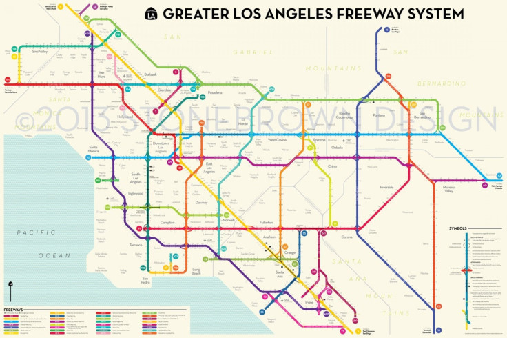
Looking at a map of the Greater Los Angeles freeway system is a bit like staring into a giant bowl of tar-colored spaghetti, and learning your way around is even less enjoyable.
What if there were an easier way? Peter Dunn, a Boston map designer who studied urban planning at the London School of Economics, thinks there is. Despite the fact that he has never driven on an L.A. freeway -- or even visited the city, for that matter -- he has designed a map of the vast network that draws on the principles of a subway map, complete with color-coded roads, large circles and straight, easy-to-follow lines.
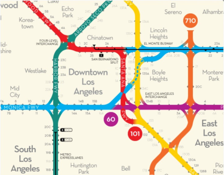
In a phone interview, Dunn said he wanted to distill the network’s 75 freeway interchanges and more than 850-plus exits into something that was both visually appealing and easily decipherable.
“I’m not showing every curve in the network,” he said. “I’m really just focusing on where the lines go and how they interconnect to give an overall picture of the system that’s really simple and clear.”
Dunn said that, when he first envisioned a subway-style freeway map, he felt Los Angeles was the obvious choice, given how central freeways are to travelers in Ventura, Los Angeles, Orange, Riverside and San Bernardino counties. Freeways are to Southern California what mass transit is to cities like New York and London.
“L.A. was the place to do this,” he said. “Freeways are such an important part of getting around.”
And locals have taken to the idea. Last month, Dunn launched a Kickstarter campaign seeking to raise $2,000 to print and distribute copies of the map. By the time the campaign came to an end on Thursday, he ended up with more than $11,000. Dunn said the extra money will go toward printing and shipping maps to his extra backers. More than 400 people have backed the project, most of whom have pledged at least at the $25 level, which means they will receive at least one copy.
By day, Dunn works as in municipal governance for Boston’s Metropolitan Area Planning Council, but he’s no stranger to creative cartography. With his company, Stonebrown Design, which he calls his “moonlighting gig,” he has designed maps for various cities, including a “time-scale” map of Boston’s subway system in which stations are spaced out according to travel time.
But it’s the L.A. freeway map that he believes has generated the most interest. After he’s through fulfilling map orders to his Kickstarter backers, Dunn hopes to pursue vendor deals, with the goal of distributing the map to local gift shops and airports. But will L.A. tourists feel comfortable buying a freeway map designed by an East Coaster who has never even seen the Hollywood Sign?
“I do think there’s an advantage to me doing this as an outsider,” Dunn said. “If it makes sense to me, it would make sense to other people who are new to the area.”
Got a news tip? Send me an email. Follow me on Twitter: @christopherzara
© Copyright IBTimes 2024. All rights reserved.
-

IMF Says Global Debt Levels Face 'Great Election Year' Risk
-

Divisions Among Colombia's FARC Dissidents Complicate Peace Talks
-

French Far Right Gets Youthful Vibe With 28-year-old Leader
-

Mideast-related Oil Price Spike Threatens 'Relatively Good' Economic Outlook: IMF Chief Economist
-

Wine Growers 'On Tip Of Africa' Race To Adapt To Climate Change
-

Despite Olympic Truce, Games Wrestle With Political Fallout
-

What Will The Fed Do With The Latest Inflation Numbers?
-

US Retail Sales Up More Than Expected In March
-

Alexandre De Moraes: Brazil Judge In Feud With Elon Musk
-

Paris 2024 Games Flame To Be Lit In Ancient Olympia


