

Saving The Mississippi River From Itself - And From Us

SIMMESPORT, La. -- Inside a nondescript building in a remote lowland bordering the Mississippi River, biologist Paul Hartfield points to a map on an overhead screen as he explains to a group of fellow biologists how he tracks a prehistoric fish that inhabits local waters.
Hartfield's talk is mostly inside-baseball stuff, though the ramifications extend far beyond the building, in part due to a dramatic scene unfolding just outside the windows.
Here, at what’s known as the Old River Control Structure Complex, about 45 miles north of the Louisiana capital of Baton Rouge, the awesome power and abundance of the Mississippi are on full display, with potentially grave consequences for all concerned.
The Mississippi has for decades been attempting to change course at Old River to follow a shorter route to the Gulf of Mexico, and in response the U.S. Army Corps of Engineers has built a series of massive concrete and steel structures to block the diversion. But doing so requires a sort of relief valve, through which as much as 600,000 cubic feet of water per second – the equivalent of the maximum flow of the Colorado River – is shunted into the smaller Atchafalaya River. Without the structures, the Atchafalaya would capture the flow of the Mississippi, which would wash away cities and communities downstream and leave New Orleans, one of the nation’s busiest ports, marooned on a stagnant backwater.
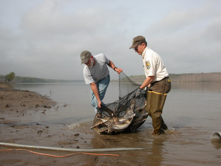
Hartfield, a white-bearded endangered-species biologist from across the river in Mississippi, has been studying aquatic ecology since 1974 and is particularly knowledgeable about the lower Mississippi. On this cold February day, he is discussing the use of radio telemetry to track the endangered fish known as the pallid sturgeon. He and the other biologists, who work for the Corps of Engineers, are engaged in tandem studies in which they capture individual fish, implant them with transmitters, and release them into the river again.

The two issues -- the potential for a catastrophic change in the river's course, and the future of the endangered fish -- overlap because of the latter's migration routes. For the pallid sturgeon, the Corps' solution to the diversion problem has physically gotten in the way.
The biologists in the room share a common interest in both topics, with a few asterisks attached. Hartfield works for the U.S. Fish and Wildlife Service, whose mission is to protect and conserve endangered species and their habitats. Everyone else works for the Corps, which is charged with maintaining navigation and flood control works across the United States. The two agencies have in the past frequently been at odds, usually over the question of whether Corps projects have contributed to the endangerment of species like the pallid sturgeon.
Owing to its military responsibilities, the influence of powerful congressional interests and the economic impact of its navigation and flood control works, the Corps has a reputation among environmental groups for being uncompromising. Yet its work at Old River is just that: a compromise, of gigantic proportions. The river’s velocity and volume and its ability to undermine its sandy bottoms to depths of 100 feet or more means that simply blocking the change of course at Old River is impossible. Instead, the Corps' structures manage the flow. The dams also influence the life cycle of the pallid sturgeon, preventing the fish from moving freely between the river systems.
The need for compromise over how to manage the river is what brought Hartfield and the Corps biologists together. The pallid sturgeon is a test case, of sorts, to show how the two federal agencies, with their often-conflicting aims, can come together to avert a potentially expensive and damaging showdown over not only the sturgeon but also two other endangered species found along the lower river. The other species are a small, skittering, fish-eating bird known as the interior least tern and a somewhat less charismatic bivalve known as the fat pocketbook mussel.
The Mississippi, the largest river in North America and the fourth longest on the planet, drains parts of 31 states and two Canadian provinces and is the most commercially important navigational system in the U.S.; notably, it also nurtures one of the largest, most productive and diverse freshwater aquatic ecosystems in the world. Federal mandates require that the Corps ensure navigation and flood control, while also taking into account the impacts of its works on fish and wildlife, and in particular, endangered species.
At issue today is how much the Corps’ works along the river and its tributaries have contributed to the endangerment of those three species, including the pallid sturgeon, which coexisted with dinosaurs and whose specific habitat needs serve as a barometer of the river’s health.

The Corps for the better part of a century had free rein on the Mississippi, but since the 1970s has been required to abide by environmental protection laws that have the potential to force major alterations to or even to block projects. Hartfield, in particular, is well known in Corps circles for his environmental efforts; until the last decade or so, he concedes, some Corps employees saw him as an outright adversary, and in many ways he was.
“There’s always been this attitude that ‘somebody’s going to win and somebody’s going to lose,’” Hartfield observed during the drive over. “With this project,” he said, “we’re working to get past that.”
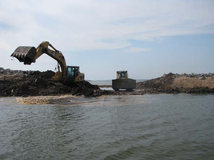
“This project” is a simple idea that the Corps came up with and abandoned years ago, but which Hartfield and another river conservationist, Ron Nasser, then the director of the Lower Mississippi Conservation Committee, resurrected. The idea seemed simple: Create comparatively small “notches” in hundreds of navigation dikes to divert partial flow into an array of secondary aquatic habitats that nurture aquatic species.
The Corps has built nearly 800 dikes along the lower Mississippi to shunt water away from secondary channels toward the main navigation channel, where the increased velocity helps keep the navigation channel open. The idea for the notches – which are typically about 100 feet long and 10 feet deep, in dikes that range up to 1,500 feet long and are about 20 feet tall – was to enable a small but steady flow into innumerable side channels, backwaters, lakes and seasonal pools that otherwise would be slowly buried in mud and sand.
Among those at the Old River meeting, Jack Killgore, a fisheries biologist with the Corps’ Engineer Research and Development Center in Vicksburg, Miss., observed that his agency’s initial concern was that the notching would draw too much water from the main channel, which would necessitate expensive dredging, and that creating openings in the dikes would weaken them structurally. Neither, he said, has proved to be the case.
After experimenting with such notches in the 1970s, the Corps abandoned the idea because of congressional funding cuts for the enabling environmental program, Killgore said.
Hartfield had a slightly different take: “The economic and political interests were not particularly interested in notching dikes,” he said, because they preferred to spend money on big construction contracts.
Either way, Hartfield figured he needed only convince the Corps that installing notches throughout the river system would reduce environmental impacts – and potential conflicts – while saving money for the Corps. So in 2001, he and Nasser began lobbying for a comprehensive notching program. Though it took more than a decade of interagency consultation before an agreement was officially signed, the Corps early on began quietly using its discretionary powers to implement the measure. The reason it took so long to reach an official consensus, Hartfield said with a wry smile, is that, “Sometimes agencies – bureaucracies – resist common sense.”
When he and Nasser proposed resurrecting the idea to the Corps in 2001, Hartfield said he found that younger biologists and engineers at the agency more receptive than their predecessors had been. “They hadn’t dealt with a full career of head-butting with the Fish and Wildlife Service, and they weren’t afraid of endangered species,” he said. “A lot of them had grown up watching ‘Animal Planet.’”
Also, he said, partially reopening the secondary channels “became an engineering challenge, and these young guys rose to the challenge.” The resulting cooperative effort was slowed somewhat when the Corps became focused on the wars in Afghanistan and Iraq and on a succession of major hurricanes and the BP oil spill, but managed to notch 230 dikes and incorporate other less environmentally destructive channel maintenance works, mostly “under the radar,” Hartfield said.
Finally, last August, representatives of the two agencies held a joint press event in Vicksburg, where both maintain regional offices, to announce a new, official conservation plan for protecting endangered species native to the lower Mississippi, based on a Corps study and a Fish and Wildlife Service report known as a biological opinion, both of which were completed last year.
The release of the plan was not exactly big news beyond the agencies and related private groups; two federal bureaucracies were officially promising to work together to save three obscure animals, in an announcement that was heavy on acronyms and governmental and scientific jargon. But in the history of the Mississippi River, the Lower Mississippi Conservation Plan was, in fact, a noteworthy moment. For the first time, the Corps’ Lower Mississippi Valley Division had agreed to use what it calls its “channel improvement program” specifically to protect fish and wildlife and create habitat diversity, for the three species that were most at risk. And the centerpiece was that simple idea for notching the dikes.
In the old days, Hartfield said, the Corps was often forced to undertake environmental restoration programs or alter its projects through litigation. The new approach, he said, “gives them more control over environmental protection – instead of being forced.”
Killgore prefers to describe the change as evidence of “the greening of the Corps.”
The good news, for both the Corps and the Fish and Wildlife Service, is that all three endangered species now appear to be rebounding. And in April, the heads of the two agencies will meet in Washington, D.C., to discuss expanding the new approach to safeguarding the environment, which could affect projects nationwide.
At Old River, the concern was not that the dams would be jeopardized but that the Corps might be required to build expensive fish ladders to enable sturgeon migrations. Hartfield said that at this point it appears that sturgeon populations are increasing in both river systems, and that should an upstream connection need to be reestablished, “The solution could be as simple as hiring local fishermen to catch the sturgeon below the dam and release them on the other side.”
In its lower Mississippi River plan, the Corps acknowledged that its works have had a detrimental environmental impact on fish and wildlife. The river in its natural state meandered freely across its broad floodplain, cutting off old bends and carving out new ones as it sought the shortest route to the Gulf, and in the process created a constantly changing array of oxbow lakes, cypress swamps, labyrinthine bayous, seasonal pools, ephemeral islands, shifting sandbars, vast logjams and deepwater holes of 150 feet or more, all of which provided different fish and wildlife habitats. But in the pursuit of navigation and flood control, the agency had made the river’s environment considerably less complex and multi-layered, so that instead of infinite gradations of habitat, there is a succession of similar habitats interspersed with natural remnants.
Since the mid-19th century, and increasingly after the infamous 1927 Mississippi River flood inundated 27,000 square miles in 10 states, the Corps has systematically sought to confine the river to a constricted route, and the river has responded by continually attempting to buck those constraints. The tug-of-war is most evident at Old River. Minute adjustments such as dike notching pale in comparison to the gargantuan task of preventing a catastrophic change in the river’s course, which would also have profound environmental consequences, but the point, Hartfield and Killgore agree, is that the two aims are not necessarily mutually exclusive.
The first manmade alteration of the Mississippi in the vicinity of Old River came in the 1830s, when an old bend of the river was cut off to ease steamboat traffic. Over time, the change in flow caused a Mississippi River tributary, the Red River, to be diverted to a nearby distributary, the Atchafalaya River, setting in motion a series of escalating changes that the Corps has spent 60 years trying to contain. The Red River had historically emptied into the Mississippi, while the Atchafalaya, just downstream on the same cutoff bend of the Mississippi, had siphoned off its overflows; eventually, the Atchafalaya captured the flow of the Red, which sped its currents and depth, which in turn caused it to capture more of the flow of the Mississippi.
In addition to the damage that would be wrought in the Atchafalaya basin in the event of a total capture, the economic losses downstream on the Mississippi would be unfathomable. The Mississippi carries an estimated 500 million tons of cargo through the port of New Orleans each year by ship and barge, provides water and waste discharge for major industries and cities from Minneapolis and Pittsburgh to New Orleans, and drains the runoff of millions of acres of fertile farmland. Since 1963, when the Corps built the first dam and floodgate at Old River to regulate flows between the two rivers, the agency has been simultaneously trying to placate and control the larger Mississippi’s monstrous and divergent power. Environmental protection was a secondary consideration, and it is not hard to understand why.
The Old River complex is a stark and daunting place. Through the gates of the structures, 30 percent of the Mississippi’s flow pours into the Atchafalaya basin, the muddy water boiling in turbulent waves on which, on this particularly day, a few dozen formerly endangered white pelicans float languorously, feasting on fish that have been stunned by their passage through the gates. Somewhere beneath them, in a murky downstream scour hole carved by the discharge currents that is estimated to be 100 feet deep, the elusive, endangered pallid sturgeon lurks.
Standing atop the original Old River control structure, one gets the sense that the Corps – not the river – is under siege. The structure seems fragile in the context of the roiling, worrisome currents, and in fact was very nearly undermined during the 1973 Mississippi River flood, when it shimmied and shook as the Corps dumped barge-loads of rock and concrete into deep scour holes that the flood currents were carving out beneath its foundations. What has happened and could happen at Old River makes simple dike-notching seem like a quaint diversion, yet both illustrate the usefulness of compromise.
Even after the construction of an ancillary floodgate in 1986, concerns remain about the future of Old River. But for now, the complex testifies to the utility of giving a little to avoid losing control of everything, which is at the center of the Corps’ new approach to incorporating small changes in its designs to accommodate Fish and Wildlife Service concerns -- to avoid having its navigational and flood control efforts stymied by environmental protection laws.
The idea for testing the waters of compromise first occurred to Hartfield in 2001, during one of his frequent forays on the river at Willow Island north of Vicksburg. “I’ve had several ‘a-ha’ moments on the river, but that day I was thinking about how biologists at both the Corps and the [Fish and Wildlife] Service tended to talk about the Mississippi like it was a dead system,” Hartfield recalled. “But Willow Island, where the Corps had experimented with notches in dikes back in the Seventies, was covered with shorebirds and pelicans, and it was a great place to fish for white and striped bass, and monster catfish. It was clearly not a dead system, and I wondered if the Corps would consider doing something like that on a larger scale.”
Few people understand the river better than Hartfield, who has spent decades plumbing its depths, casting nets, monitoring stages, setting out trot lines, camping out on its vast, lonely sandbars, swimming in its currents and plying its waters by motorboat and canoe. His scientific knowledge, experience and passion, and his understanding of how bureaucracies work, positioned him well to serve as a diplomatic crossover between the sometimes rival agencies.
In fact, Killgore noted, the Lower Mississippi River Conservation Committee’s Ron Nasser had by then already begun lobbying the Corps for a similar approach. In the late 1990s, Nasser had convinced the agency to take another stab at dike notching at a secondary channel near Memphis, and had offered to help get funding, with the result that the Corps successfully notched a series of dikes there. After Nasser and Hartfield joined forces and began meeting with Corps officials in its Memphis, New Orleans, St. Louis and Vicksburg districts, the idea began to gain momentum.
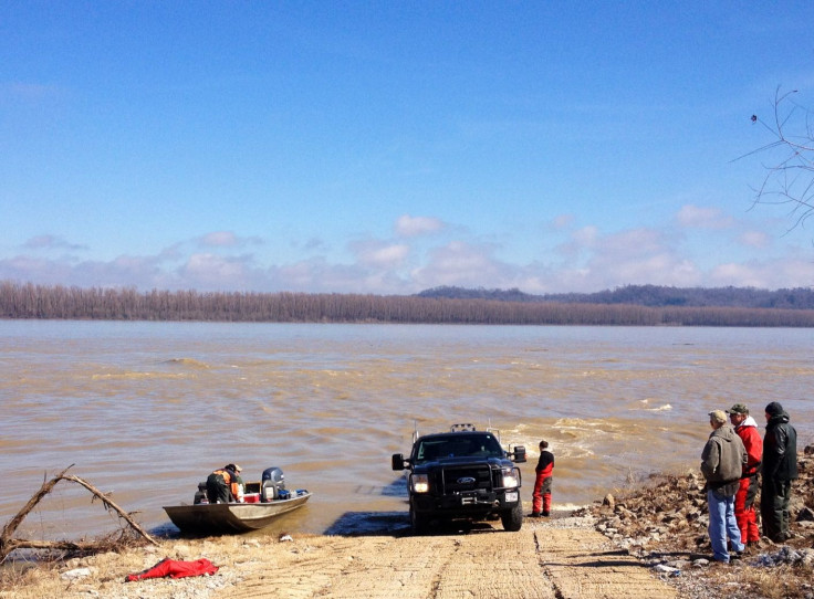
On the day of the meeting at the Old River office, the Corps biologists have themselves been casting about on the river for pallid sturgeons, aboard two government-issue boats, though they were thwarted by the cold water temperature (34 degrees Fahrenheit), which drove the fish too deep for their nets to reach. The monitoring involves catching a fish and inserting a three-inch-long, battery-powered sonic tag in an incision in its belly, which emits a pulse that can be picked up by stationary sensors mounted on bridges and other structures or by microphones submerged from biologists’ boats. The project is comparatively cheap: The tags cost less than $400 apiece, and the stationary receivers about $1,200, Hartfield said. So far, about 200 pallid sturgeons have been tagged.

Pallid sturgeon became endangered due to overharvesting for the caviar industry in the early 20th century, Killgore said. Because individuals take 10 to 15 years to reach sexual maturity, populations were slow to recover, particularly given changes in their habitat. Based on current data, the fish -- the record size for which is 24 lbs. in the lower river -- is now rebounding. While there were only 28 verified reports of pallid sturgeons in the lower Mississippi in 1990, today the Fish and Wildlife Service reports that 500 individuals have been documented in the lower Mississippi and 600 in the Atchafalaya.
Hartfield said the population of least terns along the lower river has meanwhile grown from around 300 in the 1980s to approximately 12,000 today, and the Fish and Wildlife Service is on the verge of de-listing the bird as an endangered species.
As for the mussels, Hartfield said he discovered the first living specimens of the fat pocketbook in a secondary channel behind a notched dike near Lake Providence, La., in 2003; previously, only the shells of dead mussels had indicated the species’ survival. All of which means that the recovery is well underway, with no negative impact on navigation or flood control.
Hartfield sees last summer’s joint press conference and the upcoming April meeting as milestones in the nation’s evolving approach to how to manage river resources. The upcoming meeting, he says, is envisioned as a step toward institutionalizing the headway already made, as outlined in the agencies’ two 2013 reports, which, taken together, provide what he describes as “a roadmap of how we’re managing the river and how the process works.”
“A hundred species benefit in different ways from notching and restoring flow to secondary channels,” Killgore said. He added, “In the Eighties, you had two factions fighting each other. Now, we’re collaborating -- and with Paul Hartfield, of all people.”
Hartfield noted that in its natural state, the Mississippi was slower and more environmentally complex than it is today, and supported large commercial fisheries based on river shrimp, catfish, buffalo fish, caviar and mussels. Though those days are long gone, the new approach has already improved the environment of the river, he said. In addition to aiding in the recovery of the three endangered species, dike-notching has created, enhanced or preserved habitat for recreational fishing, migratory waterfowl and songbirds.
“Everything is improved,” he said. “And fortunately, all the pieces are still there.”
© Copyright IBTimes 2024. All rights reserved.
-

Ukraine, Israel, TikTok: The Massive Aid Package Before US Congress
-

Eiffel Tower Loses Sparkle For Parisians Ahead Of Olympics
-

Former Number One Momota Retires From International Badminton At 29
-

Why Insurance Prices Have Skyrocketed
-

World Bank Aiming To Connect 250 Mn Africans To Energy Grid By 2030
-

IMF Says Global Debt Levels Face 'Great Election Year' Risk
-

Divisions Among Colombia's FARC Dissidents Complicate Peace Talks
-

French Far Right Gets Youthful Vibe With 28-year-old Leader
-

US Fed's Powell Says Inflation Fight May Take 'Longer Than Expected'
-

Mideast-related Oil Price Spike Threatens 'Relatively Good' Economic Outlook: IMF Chief Economist


