

Sluggish Tropical Storm Lee Moves Northward; Spawns Tornadoes, Floods
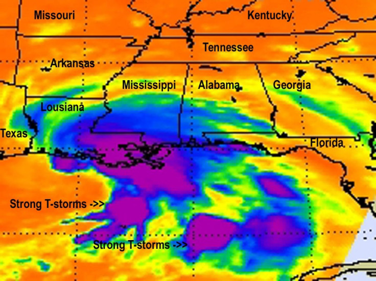
Tropical Storm Lee has begun to barrel down the Gulf Coast as heavy rains and strong winds lashed the southern part of Louisiana, Mississippi and Alabama on Saturday.
The storm has spawned multiple tornadoes and flash flooding in the New Orleans area Saturday, and residents in the town of Jean Lafitte, La. living south of Goose Bayou Bridge, have been issued an evacuation order because of possible flooding from storm surge, tides and rain.
The U.S. is on high tropical cyclone alert, as Tropical Storm Lee is forecast to swamp the Gulf Coast including New Orleans with possible severe flash flooding, and Hurricane Katia forces U.S. East Coast residents to keep a keen eye on that storm's strengthening and path.
Louisiana Gov. Bobby Jindal declared a state of emergency on Thursday, citing that the storm could drench the state with up to 15 inches of rain over the weekend.
Jindal warned that heavy rains, substantial winds and tidal surges from the Gulf of Mexico could create flash flooding in parts of New Orleans.
The slow-moving storm will dump lots of rain across the Gulf Coast and into the Southeast. Along with central and southern Louisiana, there are flood warnings for portions of inland southeast Mississippi, southwest Alabama and the western Florida Panhandle.
No death and injuries were reported, but there were some instances of water entering into homes and lapping the front doors in Louisiana.
Lee also knocked out power of thousands people in Louisiana and Mississippi on Saturday. Around 38,000 customers had lost power, but the figure was cut to 12,000 later, Entergy reported.
At 7 a.m. Saturday, the center of Tropical Storm Lee was about 110 miles west southwest of New Orleans, moving north northwest at 7 mph. Maximum winds accompanying the storm near its center are 60 mph. Forecasters said maximum winds in the New Orleans area will reach 40 to 50 mph today, with gusts to 75 mph, or near hurricane strength.
One forecaster said Lee could become a billion dollar coastal disaster for the U.S. coastal region.
From New Orleans to Mississippi rain has been relentless since Friday morning as steady downpours mixed with gusty winds of up to 40 miles per hour as Lee approached from the south on a slow moving, impacting path. Tropical storm warnings are in effect from Pascagoula, Miss. across the coast to Sabine, Texas.
Tornado watches and warnings have been posted throughout the region, according to reports. Jindal has declared a state of emergency in 10 parishes, and Mississippi has declared a state of emergency for its coastal counties.
According to the NOAA, 10 to 15 inches of rain are possible with isolated totals to 20 inches, especially south of Lake Pontchartrain and along the Mississippi coast. The storm will have maximum winds of 60 mph (95 kmh).
Meanwhile, hurricane researchers and meteorologists are keeping their eye on Hurricane Katia, which is making its way through the South Atlantic. That storm's project path according to this Google app, is still unclear, but it could definitely make its way to the East Coast.
© Copyright IBTimes 2024. All rights reserved.
-

French Air Traffic Controller Strike Threatens Flight Chaos
-

Azerbaijan Says 'Closer Than Ever' To Armenia Peace Deal Amid Border Talks
-

How UK's Biggest Water Supplier Sank Into Crisis
-

Taiwan Hit By Dozens Of Strong Aftershocks From Deadly Quake
-

Gaza Health System 'Completely Obliterated': UN Expert
-

In Ecuadoran Amazon, Butterflies Provide A Gauge Of Climate Change
-

50 Years On, Vintage Vehicles To Reenact Portugal's Carnation Revolution
-

Conflicts Push Military Spending To 'All-time High': Report
-

'Thank You, America:' Zelensky And Netanyahu Applaud House Passage Of Foreign Aid Package
-

Women Journalists Bear The Brunt Of Cyberbullying


