

Super Typhoon Haiyan: Meteorologists Say Storm In Philippines Is Unprecedented
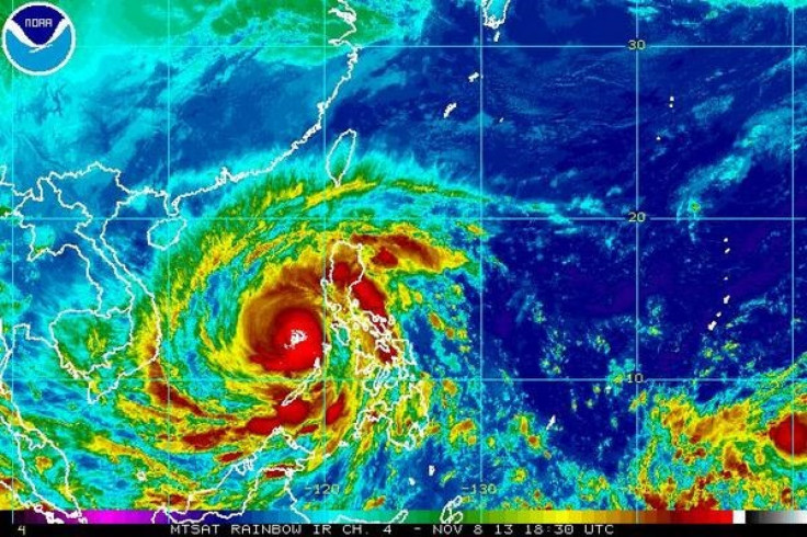
Super Typhoon Haiyan, also known as Typhoon Yolanda, began cutting a wide swath of devastation through the Philippines on Friday. Weather experts say the monster storm is unprecedented -- and with some estimates pegging the storm's strength at 190 to 195 miles per hour at landfall, it could be the strongest tropical cyclone to touch down on land in recorded history.
Damage assessments from the Pacific archipelago are still very preliminary, but sadly, most experts expect casualty reports to rise as aid workers make their way to hard-hit areas that lack electricity or phone service, according to CNN.
There is some cause for hope that the damage will be mitigated. The Philippines government acted quickly, helping more than 700,000 evacuate their homes in advance of Haiyan’s arrival, according to the New York Times. Plus, Haiyan passed quickly through the archipelago at around 25 miles per hour.
“This [fast forward speed] reduced rainfall totals, and likely flash flooding and landslides, which in numerous past typhoons have been the leading cause of death in the Philippines,” Capital Weather Gang meteorologist Jason Samenow wrote in the Washington Post on Friday.
So what brewed this monster storm? Weather Underground meteorologist Jeff Masters says that conditions out in the Pacific aren’t especially unusual right now. The area’s had pretty average ocean temperatures this year, and it’s been a perfectly average typhoon season -- typically, you see four or five storms a year, and Haiyan is the fourth this season.
For some reason, “this one just happened to get all the ingredients perfect,” Masters said in a phone interview. “The atmospheric conditions aloft were just right to allow the storm to form; once it did form, the upper-level winds were allowing more air to spiral into the center of the typhoon.”
While there have been typhoons with stronger peak winds, they tend to weaken before they make landfall. In 1961, Super Typhoon Nancy whipped up winds of 215 miles per hour -- well above the 157 mph threshold of a Category 5 storm -- while out at sea, but dropped down to a Category 2 typhoon by the time it made landfall.
Super Typhoon Haiyan “maintained Category 5 strength even after passing over several land areas -- that’s something I’ve never seen before,” Masters says.
Haiyan did weaken to a Category 4 storm after passing through the Central Philippines, and is slated to keep weakening over the weekend as it encounters colder waters and higher wind shear, Masters wrote in a blog post Friday afternoon. However, the storm will still likely be a Category 1 or Category 2 typhoon when it arrives on the coast of Vietnam. Plus, modeling suggests Haiyan will be following a curved path that will bombard more than 100 miles of the Vietnamese coast with surging waves, driving rain and punishing winds.
“With part of its circulation still over water, Haiyan will be able to pull in a huge amount of moisture that will create prodigious rains over Vietnam and Laos,” Masters wrote. “I expect that the 12+ inches of rain that the storm will dump on those nations will make it a top-five most expensive natural disaster in their history.”
© Copyright IBTimes 2024. All rights reserved.
-

IMF Says Global Debt Levels Face 'Great Election Year' Risk
-

Divisions Among Colombia's FARC Dissidents Complicate Peace Talks
-

French Far Right Gets Youthful Vibe With 28-year-old Leader
-

US Fed's Powell Says Inflation Fight May Take 'Longer Than Expected'
-

Mideast-related Oil Price Spike Threatens 'Relatively Good' Economic Outlook: IMF Chief Economist
-

Wine Growers 'On Tip Of Africa' Race To Adapt To Climate Change
-

Despite Olympic Truce, Games Wrestle With Political Fallout
-

What Will The Fed Do With The Latest Inflation Numbers?
-

US Retail Sales Up More Than Expected In March
-

Alexandre De Moraes: Brazil Judge In Feud With Elon Musk


