

Tornadoes Strike U.S. Central Plains: Meteorologists Explain Conditions Behind A Bumper Crop Of Twisters
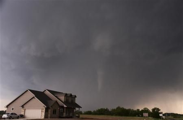
Tornadoes arrived in force in the Central Plains states over the weekend, killing at least two and injuring around 20 in Oklahoma, and sending people from Iowa to Kansas in search of shelter from the storm. The preliminary tornado count stands at 28 for Sunday and 22 for Saturday. Monday is shaping up to be another day ripe for twisters, with more possible on Tuesday.
The recent spate of tornadoes in Oklahoma and nearby states might seem unusual, but it actually isn't abnormal; weather experts say it's more of a return to form after a quiet beginning to the tornado season.
One of the two fatalities in Oklahoma was a 79-year-old man that lived in a Shawnee, Okla., mobile home park that was ravaged by a twister on Sunday.
“Mobile home parks are death traps,” Joe Golden, a retired senior meteorologist for the U.S. National Oceanic and Atmospheric Administration, said in a phone interview. “Studies have shown that in extreme wind events, where peak gusts exceed 90 to 100 miles per hour, mobile homes will begin to break apart. They’re very dangerous places to be.”
This sudden influx of tornadoes comes after a long lull. NOAA meteorologist Harold Brooks wrote on May 1 about the unusually low tornado numbers: from May 2012 to April 2013, there were about 197 significant tornadoes; before that, the previous low for a 12-month period was 247 tornadoes from June 1991 to May 1992.
So what happened to brew this bumper crop of twisters? Essentially, the wind changed.
“Until a few days ago, we’ve been in a pattern unfavorable for tornadoes, in general because the upper-level winds over the central part of the U.S. have been out of the Northwest,” Brooks said in a phone interview. Now, there’s a big flow of warm air coming up from the Gulf of Mexico. “That allows moisture to come up, and everything comes together.”
Plus, it got warmer -- over the weekend, temperatures in several Tornado Alley states climbed into the 90s.
"What you have is a combination of factors that are classic for tornado outbreaks in the central plains: a flow of very humid, very warm air streaming northward; then coming over that is a jet stream with much colder air and strong wind shear," Golden says.
The essential ingredients for tornado formation are warm, moist air nearer to the ground, with cold dry air higher up, and winds coming from different directions. And those conditions are more likely to occur in the springtime.
“Every spring we get large masses of cold air out of Canada interacting with warm moist air out of the Gulf of Mexico,” says University of Oklahoma meteorologist John Snow. “The consequence of that is strong thunderstorms. And with strong thunderstorms, there’s the potential for severe weather.”
There tends to be fewer tornadoes in the central U.S. in winter because the air from the south isn’t coming off of the Gulf; instead, it’s dry air coming off the Mexican deserts. There will still be tornadoes in the U.S. in winter, but these generally form close to the Gulf and don’t move very far inland, according to Snow.
When the conditions are ripe for one tornado, they’re ripe over a broad area, so multiple tornadoes can often be expected.
“The [air] flow patterns are relatively big, so 10 tornadoes in a day is not that uncommon,” Brooks said.
So it’s not rare for a single storm to produce multiple tornadoes.
“As one is dissipating, a new one is forming,” Brooks said. “And the second will form relatively close to the old one. If you’re flying along, you’d see the tornadoes forming in the back part of the storm.”
Tornadoes are more common than you might think. There's usually at least one forming on every day of the year -- "even on the February 29th of a leap year," Snow says -- and not just in the Midwest.
Tornadoes in places like New York are rarer and usually weaker. Being up farther north means it's less likely for the right combination of warm air and cold air to occur. But they do happen -- a pair of twisters touched down in Brooklyn and Queens last September, and Washington, D.C., will get the occasional tornado watch or warning when a severe storm passes through.
Thankfully, modern technology allows weather scientists to keep a close watch on tornadoes and their precursor storms. While satellites might get all the glory in weather coverage, the real workhorse for tornado prediction is radar.
“Radar is a really fancy tool these days,” Snow says.
Meteorologists can use radar to monitor the precipitation droplets that form clouds; Doppler capability allows them to watch the particles moving. As a storm cloud spins, weather experts look for the particular “signatures” that usually precede a tornado formation. One of those signatures is the “hook-echo,” which forms when rotation within the storm around an updraft starts to drag the particles of precipitation all the way around.
“You get this hook-shaped feature on the flank of the cloud, where material is wrapping around an updraft,” Snow says. “Then we know that the storm is rotating fairly intensely.”
New upgrades to weather monitoring include dual-polarization radar, which examines storm clouds at a much higher resolution than previously attainable.
"You can see the circulations that lead to tornado development in much greater detail," Golden says.
More powerful computing may also accelerate meteorologists' ability to predict when a tornado is about to form.
“Right now we do the warnings based on actually seeing something – whether on radar or from a state trooper or someone on the ground. That’s ‘warn on detection,’” Snow says. “We want to move over this decade to ‘warn on forecast’ -- instead of five to 15 minute warnings, we want 45-minute to an hour-type warnings. That would offer people more options to get out of the way.”
© Copyright IBTimes 2024. All rights reserved.
-

Taiwan Hit By Dozens Of Strong Aftershocks From Deadly Quake
-

Gaza Health System 'Completely Obliterated': UN Expert
-

In Ecuadoran Amazon, Butterflies Provide A Gauge Of Climate Change
-

50 Years On, Vintage Vehicles To Reenact Portugal's Carnation Revolution
-

Conflicts Push Military Spending To 'All-time High': Report
-

'Thank You, America:' Zelensky And Netanyahu Applaud House Passage Of Foreign Aid Package
-

Women Journalists Bear The Brunt Of Cyberbullying
-
US Aid Shows Ukraine Will Not Be 'Second Afghanistan': Zelensky
-

Elon Musk's X Fights Australian Watchdog Over Church Stabbing Posts
-

Ukraine, Israel, TikTok: The Massive Aid Package Before US Congress


