

Tropical Cyclone Phailin: Storm As Strong As Hurricane Katrina Threatens Indian Coast
Tropical Cyclone Phailin is fast approaching the northeast coast of India, and the outlook is dire as forecasters predict it will bring epic destruction to the region.
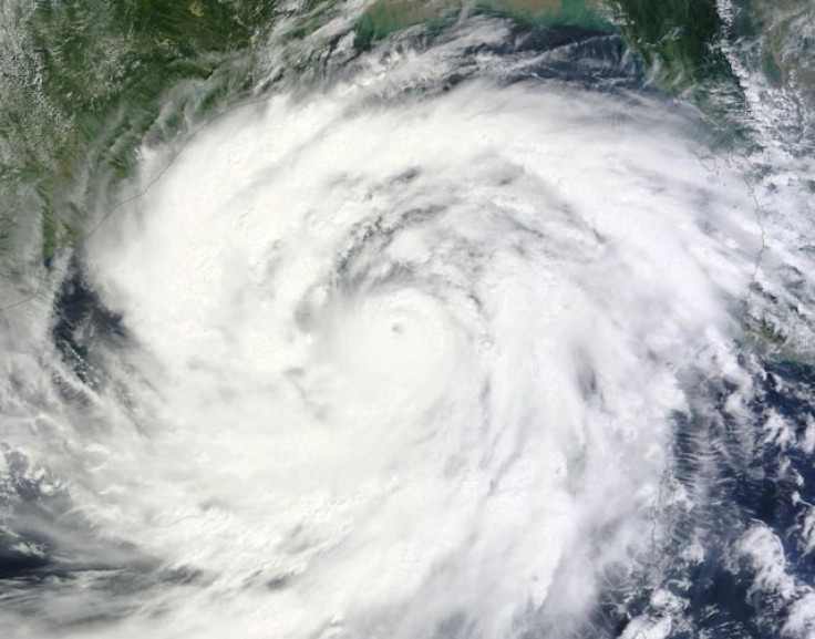
The storm, said to be double the width of tropical storm Sandy -- read: almost half the size of India -- and as strong as Hurricane Katrina, is being described as perhaps the largest storm ever to arise from the Bay of Bengal. It will at least be the largest and most devastating one since the 1999 Odisha cyclone, which killed more than 9,800 people and caused $4.5 billion in damage.
An estimated 260,000 people have already evacuated along the coastline of India, where Cyclone Phailin, aka Tropical Cyclone 02B, is expected to make landfall near Gopalpur by Saturday evening, according to Reuters, and the exodus will continue as the cyclone nears. Phailin has been described by the India Meteorological Department (IMD) as a "very severe cyclone" with maximum sustained wind speeds topping 135 miles per hour, though many consider that to be an underestimate of its true potential strength.
Meteorologists at the Weather Underground say the force of the cyclone "put on a phenomenal burst of rapid intensification on Thursday, going from a tropical storm with 65 mph winds to a top-end Category 4 storm with 155 mph winds in just 24 hours," but forecasters predict it will continue to intensify.
The Joint Typhoon Warning Center (JTWC) predicted Friday that maximum wave heights at sea could reach 56 feet and that "the system is expected to slightly intensify to a peak of 145 knots over the next 12 hours as favorable conditions persist. After landfall, TC Phailin will rapidly erode as it tracks across the rugged terrain of Northern India."
If the storm does indeed hit 145 knots (nearly 167 miles per hour), Phailin will be upgraded to Category 5 status, the most dangerous class of storm, defined by the Saffir-Simpson Hurricane Wind Scale as having maximum sustained wind speeds over 157 miles per hour.
The IMD predicted Friday that storm surges as high as 11 feet will strike certain low-lying coastal areas, while "extensive damage" to certain types of buildings can be expected along with wide-scale power outages, major flooding and disruption of railways and roads. The Weather Underground predicts that because the part of the Indian coast where Cyclone Phailin is expected to make landfall "is not as low-lying, [that] should keep the death toll due to storm surge much lower compared to the 1999 Odisha Cyclone, where more than 70 percent of the deaths occurred due to the storm surge."
In the event of a Category 5 hurricane making landfall, the Saffir-Simpson Hurricane Wind Scale states that, "Catastrophic damage will occur: A high percentage of framed homes will be destroyed, with total roof failure and wall collapse. Fallen trees and power poles will isolate residential areas. Power outages will last for weeks to possibly months. Most of the area will be uninhabitable for weeks or months."
Phailin, pronounced "pie-leen," means sapphire in Thai. The cyclone is the most recent in a seemingly endless series of major storms to form in the Bay of Bengal, where 26 of the 35 deadliest tropical cyclones in recorded history have formed, according to the Weather Underground.
Meanwhile, Category 3 Typhoon Nari is expected to make landfall soon in the northern Philippines, where it could cause extensive damage as Cyclone Phailin decimates the Indian coast. This weekend will be a particularly dangerous time for major storms in Asia.
© Copyright IBTimes 2024. All rights reserved.
-

Taiwan Hit By Dozens Of Strong Aftershocks From Deadly Quake
-

Gaza Health System 'Completely Obliterated': UN Expert
-

In Ecuadoran Amazon, Butterflies Provide A Gauge Of Climate Change
-

50 Years On, Vintage Vehicles To Reenact Portugal's Carnation Revolution
-

Conflicts Push Military Spending To 'All-time High': Report
-

'Thank You, America:' Zelensky And Netanyahu Applaud House Passage Of Foreign Aid Package
-

Women Journalists Bear The Brunt Of Cyberbullying
-

US Aid Shows Ukraine Will Not Be 'Second Afghanistan': Zelensky
-

Elon Musk's X Fights Australian Watchdog Over Church Stabbing Posts
-

Ukraine, Israel, TikTok: The Massive Aid Package Before US Congress


