

Tropical Storm Lee Threatens Massive Flooding in Alabama, Louisiana, Mississippi
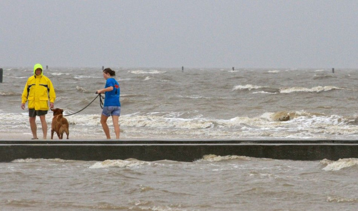
The rain keeps falling in New Orleans and along the Gulf Coast as Tropical Storm Lee pushes closer, and it's likely only going to get worse.The slow-moving storm is expected to bring massive flooding to some areas Alabama, Louisiana and Mississippi this Labor Day weekend.
Lee is spawning tornado warnings, evacuation and knocking out power in New Orleans and southern Louisiana on Saturday.
Lee has strengthened and continues pounding New Orleans and the Gulf Coast region with heavy rain and flooding threat. The storm has spawned multiple tornadoes and flash flooding in the New Orleans area Saturday, and residents in the town of Jean Lafitte, La. living south of Goose Bayou Bridge have been issued an evacuation order because of possible flooding from storm surge, tides and rain.
Also, a flash flood warning was issued for St. Tammany Parish Saturday morning, for cities including Slidell, Mandeville, Eden Isle and Covington, as heavy rainfall from thunderstorms embedded in squall lines from the eastern perimeter of Tropical Storm Lee pounding the area.
A tropical storm warning is in effect until at least Tuesday as the storm moves slowly, eventually on shore before making its way up through Louisiana, Mississippi, Alabama and Tennessee.
The center of Tropical Storm Lee was about 145 miles southwest of Morgan City, La.,, moving north northwest at 7 mph. Maximum winds accompanying the storm near its center are 60 mph. Forecasters said maximum winds in the New Orleans area will reach 40 to 50 mph today, with gusts to 75 mph, or near hurricane strength.
One forecaster said Lee could become a billion dollar coastal disaster for the U.S. coastal region.
Rain from New Orleans to Mississippi has been relentless since Friday morning as steady downpours mix with gusty winds of up to 40 miles per hour as Lee approaches from the south on a slow moving, impacting path. Tropical storm warnings are in effect from Pascagoula, Miss. across the coast to Sabine, Texas.
Tornado watches and warnings have been posted throughout the region, according to reports. Louisiana Gov. Bobby Jindal has declared a state of emergency in 10 parishes, and Mississippi has declared a state of emergency for its coastal counties.
Forecasts call for some areas of the coastal region including New Orleans to get as much as 20 inches of rain -- that's five more than New Orleans got in Katrina, when levees breached from Lake Pontchartrain, flooding the city and claiming hundreds of lives.
The bottom line for folks is to know regardless of what they call it, if you live in south Louisiana, especially southeast Louisiana, you are going to see a lot of rain between now and Tuesday, Jindal told ABC.
Tropical Storm Lee is expected to make landfall along Louisiana's central coast today, before moving toward New Orleans. Wind speeds aren't the biggest concern, though Lee has gained strength, with sustained winds approaching 60 miles per hour.
Rather, Lee poses significant risk to the region because it is moving slow and drenching the region, and flooding is expected to be severe in some areas. Also, while Lee doesn't pack a hurricane punch at its core, the storms wind and rains extend far.
Tropical storm force winds and heavy rains are spread out all the way from Louisiana to Alabama and almost into northwest Florida, said National Hurricane Center specialist Eric Blake.
The threat level from tropical storm Lee from the northern Gulf Coast to the Tennessee Valley is medium to high, according to The Weather Channel, with significant impacts from continual flooding rains.
Flooding is a huge concern from the Gulf Coast to the Southern Appalachians...locally 20 of rain is not out of the question near the Gulf coast! The Weather Channel reports.
Persistent onshore wind flow could lead to significant coastal flooding along the northern Gulf coast, while high surf and rip currents are dangerous threats to Labor Day weekend beach goers. Lee's wind threat is low, but that could increase if Lee intensifies in the warm gulf waters.
Lee is so slow moving, the storm will likely remain in Louisiana Labor Day morning, north of Louisiana and approaching Mississippi, with winds of 45 miles per hour, according to forecasts. The storm is expected to move slow through Mississippi, Alabama and Tennessee, reaching the Huntsville and Chattanooga region early Wednesday morning, with heavy rain and gusting winds.
In New Orleans, officials have posted online a list of streets prone to flooding, and the city has swift-water rescue teams on alert. Authorities are confident, however, New Orleans' revamped levee system will hold during Lee. The system has recently undergone a multi-billion dollar upgrade after Hurricane Katrina flooding in 2005.
Alex Sosnowski, a senior meteorologists at AccuWeather.com, wrote Friday that the storm has the potential to be the next billion-dollar disaster for the U.S., by way of epic flooding.
Some areas in greater New Orleans have already received about six inches of rain, according to WeatherBug, a private weather service. Also, high winds from storms and possibly tornadoes hve knocked out power for about 20,000 in the New Orleans area by late Saturday morning.
New Orleans officials also reported rising water near the Chef Pass bridge, and flooding at Lake Marina Drive and West Roadway and at the Interstate 610 ramp at Elsysian Fields Boulevard.
© Copyright IBTimes 2024. All rights reserved.
-

IMF Says Global Debt Levels Face 'Great Election Year' Risk
-

Divisions Among Colombia's FARC Dissidents Complicate Peace Talks
-

French Far Right Gets Youthful Vibe With 28-year-old Leader
-

US Fed's Powell Says Inflation Fight May Take 'Longer Than Expected'
-

Mideast-related Oil Price Spike Threatens 'Relatively Good' Economic Outlook: IMF Chief Economist
-

Wine Growers 'On Tip Of Africa' Race To Adapt To Climate Change
-

Despite Olympic Truce, Games Wrestle With Political Fallout
-

What Will The Fed Do With The Latest Inflation Numbers?
-

US Retail Sales Up More Than Expected In March
-

Alexandre De Moraes: Brazil Judge In Feud With Elon Musk


