

Tropical Storm Maria 2011 Path: Will Maria hit the U.S.? [MAPS]

Tropical Storm Maria is set to drive through the Lesser Antilles tonight before tracking towards Puerto Rico and on toward the U.S. coast.
It is still too soon to say whether or not the storm will make landfall in the U.S., however the majority of forecast models show the storm following a similar path as Hurricane Katia, currently in the Atlantic about 385 miles south-southwest of Halifax, Nova Scotia.
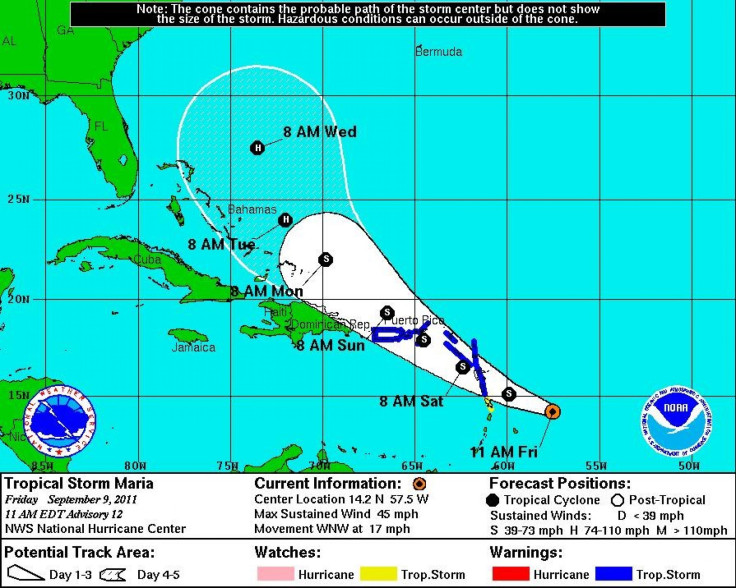
Tropical Storm Maria is currently located about 350 miles southeast of the Leeward Islands with maximum sustained winds of 45 mph. At present, the storm is moving west-northwest at 17 mph, according to an 11 a.m. EDT alert from the National Hurricane Center in Miami. That general motion is expected to continue during the next day as the center of the storm reaches the Lesser Antilles early Friday and heads over, or near the Virgin Islands by Saturday Night.
Tropical-storm-force winds extend outward up to 175 miles, mainly to the northeast of the storm center.
A tropical storm warning is in effect for Antigua, Anguilla, Barbuda, Dominica, Guadeloupe, Montserrat, Nevis, Saba Saint Kitts, St. Maartin, St. Eustatius.
A tropical storm warning is also in effect for the U.S. and British Virgin Islands as well as Puerto Rico, including Vieques and Culebra.
A tropical storm watch is in effect for Martinique, St. Barthelemy and St. Marteen.
The National Hurricane Center urged interests in the Dominican Republic, the Turks and Caicos, and the Southeastern Bahamas to monitor the progress of Maria.
The storm is expected to strengthen slightly over the next 48 hours, but it is not due to reach Hurricane strength until Tuesday, when it is predicted to be northeast of the Bahamas.
As storm paths change hourly, it's still far too early to say what, if any, impact Tropical Storm Maria would have on the East Coast of the United States.
Elsewhere in the Atlantic, Hurricane Katia passed between Bermuda and the East Coast of the United States Thursday and remained off the coast with maximum sustained winds of 85 mph Friday morning. Forecast models show Katia heading out to sea and making a rapid journey across the Atlantic north of the United Kingdom and possibly toward Norway.
On Friday, the National Hurricane Center reiterated its warning that large swells generated by Katia will continue to affect the Northeast Coast, creating potentially life-threatening surf and rip current conditions.
A third named storm developed midweek in the Gulf of Mexico. The highly erratic Tropical Storm Nate, located just north of the Yucatan Peninsula, is currently meandering over the bay of Campeche. According to the 10 a.m. EDT alert from the National Hurricane Center in Miami, Nate had maximum sustained winds of 65 mph and was expected to strengthen over the next 48 hours.
The government of Mexico issued a hurricane watch from Tampico to Verazruz and a tropical storm watch from Tampico to La Cruz and from Veracruz to Punta El Lagarto. These are in addition to the earlier watches and warnings.
The storm is expected to strengthen into a hurricane in the next 48 hours and approach the coast of Central Mexico by Sunday.
It's turning out to be the unusually busy year that forecasters had predicted. The Atlantic hurricane season typically brings 11 or 12 named storms. Tropical Storm Nate is the 14th, and nearly half of the season lies ahead.
© Copyright IBTimes 2024. All rights reserved.
-

IMF Says Global Debt Levels Face 'Great Election Year' Risk
-

Divisions Among Colombia's FARC Dissidents Complicate Peace Talks
-

French Far Right Gets Youthful Vibe With 28-year-old Leader
-

US Fed's Powell Says Inflation Fight May Take 'Longer Than Expected'
-

Mideast-related Oil Price Spike Threatens 'Relatively Good' Economic Outlook: IMF Chief Economist
-

Wine Growers 'On Tip Of Africa' Race To Adapt To Climate Change
-

Despite Olympic Truce, Games Wrestle With Political Fallout
-

What Will The Fed Do With The Latest Inflation Numbers?
-

US Retail Sales Up More Than Expected In March
-

Alexandre De Moraes: Brazil Judge In Feud With Elon Musk


