

Tropical Storm Maria Path 2011: New Track shows Possible U.S. Hit [MAPS]

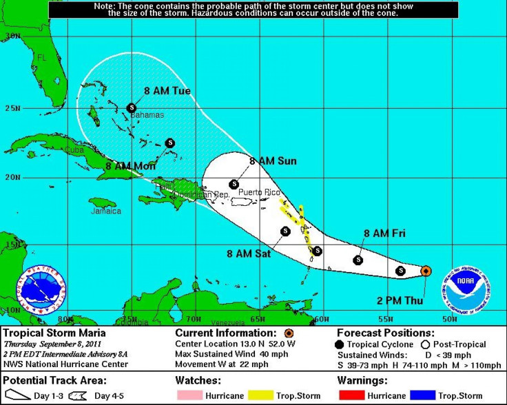
Tropical Storm Maria is now on track to swipe the Windward Islands, plow through Puerto Rico, and head on up through the Bahamas toward Florida.
Of course, these predictions are highly susceptible to change.
Tropical Storm Maria is currently located about 560 miles east of the Windward Islands with maximum sustained winds of 40 mph. At present, the storm is moving west at 21 mph, according to a 5 p.m. EDT alert from the National Hurricane Center in Miami. That general motion is expected to continue today, followed by a turn toward the west-northwest and a decrease in forward speed on Friday.
On its forecasted track, the center of Maria will be near the Leeward Islands late Friday and moving over the northeastern Caribbean Sea on Saturday.
Tropical-storm-force winds extend outward up to 175 miles to the north of the storm center.
A tropical storm watch is in effect for Antigua, Anguilla, Barbuda, Dominica, Guadeloupe, Martinique, Montserrat, Saint Kitts and Nevis, Saba, St Barthelemy, St Marteen, St Maartin, and St. Eustatius.
The National Hurricane Center urged interests elsewhere in the Leeward Islands, the Virgin Islands, and Puerto Rico to monitor the storm.
Maria is not expected to become a hurricane anytime soon. In fact, surface observations and satellite imagery suggest that Maria could be in the process of degenerating into a tropical wave.
If the storm does not degenerate, there is a chance that it could pose a threat to the U.S. East Coast, though it's still far too early to say what, if any, impact Tropical Storm Maria would have.
Elsewhere in the Atlantic, Hurricane Katia passed between Bermuda and the East Coast of the United States Thursday with maximum sustained winds of 85 mph. Forecast models show the slowly weakening storm heading out to sea back across the Atlantic north of the United Kingdom and possibly toward Norway.
On Thursday, the National Hurricane Center warned that large swells generated by Katia are due to affect most of the East Coast through the weekend, creating potentially life-threatening surf and rip current conditions.
A third named storm has developed in the Gulf of Mexico. The highly erratic Tropical Storm Nate, located just north of the Yucatan Peninsula, is currently meandering over the bay of Campeche. According to the 4 p.m. EDT alert from the National Hurricane Center in Miami, Nate had maximum sustained winds of 70 mph and was expected to strengthen over the next 48 hours. The storm is not expected to move much overnight, but a slow northward to north-northwestward motion is forecast for Friday, at which time the storm will likely be a hurricane.
It's turning out to be the unusually busy year that forecasters had predicted. The Atlantic hurricane season typically brings 11 or 12 named storms. Tropical Storm Nate is the 14th, and nearly half of the season lies ahead.
© Copyright IBTimes 2024. All rights reserved.
-

Gaza Health System 'Completely Obliterated': UN Expert
-

In Ecuadoran Amazon, Butterflies Provide A Gauge Of Climate Change
-

50 Years On, Vintage Vehicles To Reenact Portugal's Carnation Revolution
-

Conflicts Push Military Spending To 'All-time High': Report
-

'Thank You, America:' Zelensky And Netanyahu Applaud House Passage Of Foreign Aid Package
-

Women Journalists Bear The Brunt Of Cyberbullying
-

US Aid Shows Ukraine Will Not Be 'Second Afghanistan': Zelensky
-

Elon Musk's X Fights Australian Watchdog Over Church Stabbing Posts
-

Ukraine, Israel, TikTok: The Massive Aid Package Before US Congress
-

Eiffel Tower Loses Sparkle For Parisians Ahead Of Olympics


