

Winter Storm Saturn: 'Snowquester' Is Coming For DC, But The Cherry Blossoms Should Be Safe
March is roaring in like a lion, with a new winter storm poised to dump snow and rain from the Midwest to the Atlantic. Hard to believe spring is technically about two weeks away, no?
Dubbed Winter Storm Saturn by The Weather Channel and the “Snowquester” by the Washington Post’s Capital Hill Weather Gang, the storm is a fast-moving system called an Alberta clipper that’s beating a path southeast from Canada. (The recent Winter Storm Nemo, you may recall, was an Alberta clipper that mated with another storm system that moved up from the southeast.)
“This Clipper is traversing through an atmosphere that is warmer than usual for these types of storms -- close to the freezing point near the surface,” Weather Underground meteorologist Jeff Masters wrote on Tuesday. “Since warm air can hold more moisture, this Clipper is bringing heavier snowfall amounts than is usual for a Clipper.”
Snow is already falling in the Midwest, with parts of North Dakota and Minnesota seeing up to 10 inches. The flakes are already falling on Chicago, which could get its heaviest snowfall of the season, with somewhere between 6 and 9 inches expected.
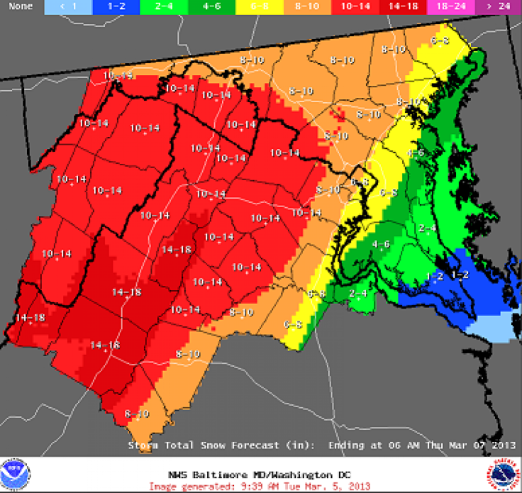
When Winter Storm Saturn gets to the Eastern seaboard, it will likely mean heavy, wet snow for the Washington, D.C., area, with an accumulation of somewhere between 3 and 8 inches expected. Winter storm warnings are already in place for western Virginia. Rain or a wintry mix should start falling in the D.C. area on Tuesday night.
Thankfully, the weather shouldn't affect D.C.'s famous cherry blossom trees.
"It's not really unusual for us to have weather that can vary 50 degrees or more at this time of year," National Park Service cherry tree expert James Perry said in a phone interview. "At the stage the trees are at, [the snow] won’t negatively affect them."
Perry predicted earlier this week that the buds would open between March 26 and March 30. Right now, the developing flowers are well-protected inside their buds.
However, in future years, the cherry trees might not be so lucky. Peak bloom dates have been inching earlier in recent years. The average blooming date is April 4, but in 2012, the flowers opened on March 20. In a November 2011 paper published in the journal PLoS ONE, a research team led by a University of Washington horticulturist estimated how early the peak bloom date could be pushed back thanks to climate change. Under the most conservative model, peak bloom dates will be an average of five days earlier by 2050 and 10 days earlier by 2080. Another scenario, assuming higher rates of carbon emissions, predicts peak flowering will move back 13 days by 2050 and 29 days by 2080.
If the cherry trees start flowering in mid-March or earlier, there's a huge risk that the blossoms could be felled by a late-season winter storm like Saturn. This phenomenon played out last year in Wisconsin, where unseasonably warm temperatures prompted the tart cherry trees in the northeast part of the state to flower early, leaving the fruit buds open to damage from freezing winds in late March. Wisconsin cherry farmers lost more than 90 percent of their harvest in 2012.
Saturn will likely be the biggest snowstorm for the capital since a January 2011 squall that the Capital Weather Gang nicknamed “Commutageddon” after snow and sleet hit D.C. just as most workers were headed home. Many people were stuck at work, or amid paralyzed traffic, for hours. Saturn or Snowquester, whichever you prefer, probably won’t match the February 2010 “Snowmageddon” storm that dumped more than two feet of snow on D.C.
Still, Saturn is nothing to sneeze at.
“This is easily the biggest snow threat we’ve seen over the past two winters,” Capital Weather Gang meteorologist Matt Rogers wrote on Tuesday.
Even more snow could end up piling up high in the Appalachians, with possibly more than 18 inches accumulating in the highest parts of West Virginia, according to the National Weather Service. New England and New York could also see heavy snows on Wednesday and later, but the exact amount is still uncertain.
“There will be a very sharp gradient in the precipitation amounts, and the storm's track may keep the heaviest snows just offshore,” Masters wrote.
The snow should end for the mid-Atlantic area on Wednesday night, and warmer temperatures leading up to the weekend should ensure that it doesn’t stick around on the streets for very long. But after the storm moves off the Atlantic coast, it could cause coastal flooding to areas of Delaware already damaged by Hurricane Sandy this past October, Masters wrote on Monday.
© Copyright IBTimes 2024. All rights reserved.
-

IMF Says Global Debt Levels Face 'Great Election Year' Risk
-

Divisions Among Colombia's FARC Dissidents Complicate Peace Talks
-

French Far Right Gets Youthful Vibe With 28-year-old Leader
-

US Fed's Powell Says Inflation Fight May Take 'Longer Than Expected'
-

Mideast-related Oil Price Spike Threatens 'Relatively Good' Economic Outlook: IMF Chief Economist
-

Wine Growers 'On Tip Of Africa' Race To Adapt To Climate Change
-

Despite Olympic Truce, Games Wrestle With Political Fallout
-

What Will The Fed Do With The Latest Inflation Numbers?
-

US Retail Sales Up More Than Expected In March
-

Alexandre De Moraes: Brazil Judge In Feud With Elon Musk


