

ESA's GOCE satellite gives breakthrough gravity field data
The unique new geoid model explains why gravitational force differs from location to location
A sophisticated satellite of the European Space Agency (ESA) has mapped Earth's gravity with unprecedented precision, helping scientists have clearer understanding of the variation in the gravitational force in different parts of the planet and how this may affect crucial events like an earthquake.
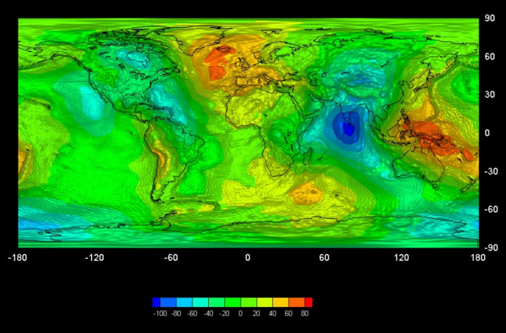
The satellite has recorded the measurements necessary to produce a high-resolution map of the 'geoid', an ESA statement has said. The geoid is the shape of an imaginary global ocean dictated by gravity in the absence of tides and currents. It is a crucial reference for accurately measuring ocean circulation, sea-level change and ice dynamics – all affected by climate change.
The Gravity Field and Steady-State Ocean Circulation Explorer (GOCE) was launched in March 2009. The satellite completed its 12th month of gravity-field mapping early this month. The scientists then put together the data to create a unique model of the geoid.
Once the gravity models are completed, they will be made available to all users, free of charge in line with ESA's data policy, ESA has said.
SIGNIFICANCE OF NEW GEOID MAP
The geoid essentially describes the level surface on an idealized world, says a BBC report. ... if you were to place a ball anywhere on this potato, it would not roll because, from the ball's perspective, there is no up or down on the undulating surface.
But this is the trick gravity plays on Earth because the space rock on which we live is not a perfect sphere and its mass is not evenly distributed.
CLIMATE STUDIES
The new geoid model gives fresh insights into how the oceans are moving and how they redistribute the heat from the Sun around the world, according to the report. This information will add remarkable depth and breadth to climate studies.
We are seeing completely new information in areas like the Himalayas, the Andes mountain range, and in Antarctica particularly,” Dr Rune Floberghagen, the European Space Agency's Goce mission manager, is quoted in the report as saying.
EARTHQUAKE
The new geoid model will give significant clues to what is happening inside Earth. Devastating earthquakes are the result of the movement of huge masses of rock inside Earth, and the new data can give clues as to what influences these movements as well as the role of gravitational pulls.
BETTER GRAVITY FIELD INFORMATION
The GOCE findings are a breakthrough inasmuch as it provides better gravity field information on mountain ranges like the Himalayas and the Andean.
The satellite flew at an altitude of just 254.9km, at which level it captured minutest accelerations of the gravity experienced on Earth, helping map the almost imperceptible differences in the pull exerted by the mass of the planet from one place to the next - from the great mountain ranges to the deepest ocean trenches, the report says.
© Copyright IBTimes 2025. All rights reserved.
- MOST POPULAR IN Society


