

MH370: Malaysia Rejected Inmarsat Data For 5 Days, Report Says; Search Could End By May 2015
In the search effort for Malaysia Airlines Flight MH370, Malaysian authorities initially rejected crucial data from British satellite company Inmarsat for nearly five days after the jet’s disappearance on March 8, sources told The West Australian. The search for the missing plane has lasted for over nine months without yielding any concrete clues.
In a report released Sunday, The West Australian said, citing British sources, that authorities ignored Inmarsat’s data suggesting that the plane crashed in the southern Indian Ocean, because of which “crucial days were lost.” The report also said that Malaysian authorities took the findings seriously only after Inmarsat approached Britain's Air Accidents Investigation Branch (AAIB) with its data.
"They didn't want to know," the paper quoted the source. "It also took days before Malaysian military radar tracking data was made available," the report added.
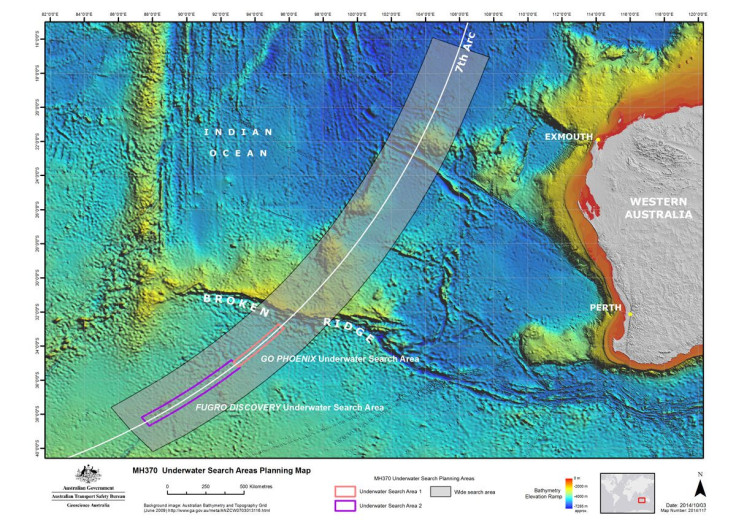
The search for Flight MH370 was moved to the southern Indian Ocean on March 16. Investigators now believe that the final resting place of the aircraft could be along the seventh arc, which has been described as “a thin but long line that includes all the possible points where the last known communication between the aircraft and the communication satellite could have taken place.”
Inmarsat’s report, which claimed that Flight MH370 ran out of fuel and crashed in a remote part of the southern Indian Ocean, had also came under scrutiny. However, the U.S. National Transportation Safety Board, the AAIB and the Australian Transport Safety Bureau agreed with the data released by Inmarsat, whose satellite was the last one to communicate with the Boeing 777.
Meanwhile, the Joint Agency Coordination Centre (JACC) said Sunday that the search for the jetliner, which has become one of the costliest in aviation history, could end by May 2015 if there are no delays linked to vessels, equipment or natural obstacles, The Guardian reported.
Last week, Australian officials leading the search released pictures of the floor of the Indian Ocean where officials hope to locate the debris of the missing plane. The latest update on the search revealed that survey vessel Fugro Equator is mapping the ocean floor and is expected to return to Fremantle, in Western Australia, in mid-December. An area of nearly 77,220 square miles of the search area has been so far scoured in an effort to look for the plane or its remains.
© Copyright IBTimes 2025. All rights reserved.
- MOST POPULAR IN Business


