

800,000 New York City Residents Could Be In Flood Zones By 2050

New Yorkers of the future are likely to face wider flooding, placing more than 800,000 city residents in flood zones that would encompasses a quarter of the city's land.
This soggy prediction comes from a study by a group of climate scientists advising the city, reports the Associated Press.
By the 2050s, ocean waters are expected to be a foot to two and a half feet higher than current levels. And 8 percent of the city's coastline could see regular flooding from high tides. The group also estimates that a so-called 100-year storm could produce a storm surge five or more feet greater than the city experienced with Hurricane Sandy -- the October 2012 "superstorm" that sent a record-setting 14-foot tide into Lower Manhattan.
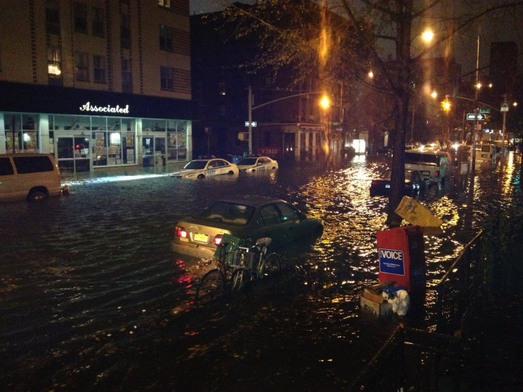
The wave of water crippled much of Lower Manhattan for many weeks, and many businesses and communities are continuing to recover from the devastation of the extreme flooding.
The MTA is looking at a price tag of at least $600 million to restore the South Ferry subway terminal that opened in 2009, reports NBC News.
Mayor Michael Bloomberg will present recommendations to accompany the report on Tuesday.
"We have to look ahead and anticipate any and all future threats, not only from hurricanes and other coastal storms but also from droughts, heavy downpours and heat waves and many of which are likely to be longer and more intense in the years to come," said an excerpt from the mayor's prepared text.
In his speech on Tuesday, the mayor may detail the total cost such an overhaul would require, says Reuters.
The Federal Emergency Management Agency also released proposed changes to the city's flood zone maps. The new maps nearly double the 218,000 people and 35,000 buildings currently located in once-in-100-year flood zones. These maps are not official, though, until a review of almost two years is complete.
Bloomberg, like other observers, has also said global warming may have played a role in Sandy and the increased instances of severe weather the region has experienced.
"What is clear is that the storms we've experienced in the last year or so around this country and around the world are much more severe than before," he said last October at a press conference following Sandy. "Whether that's global warming or what, I don't know, but we'll have to address those issues."
© Copyright IBTimes 2024. All rights reserved.
-

Microsoft Expands Its AI Empire Abroad
-

Oil: 'Mother Of Corruption' In Venezuela
-

'Extreme' Climate Blamed For World's Worst Wine Harvest In 62 Years
-

Macron Warns 'Mortal' Europe Needs Credible Defence
-

Bitcoin And Crypto Price Review - Another Myth Gets Busted?
-

Mass Cancellations Loom Despite French Air Union Cancelling Strike
-

Mired In Crisis, Boeing Reports Another Loss
-

Recycled 'Zombie' Misinformation Targets US Voters
-

Hackers Leak Part Of Source Code Of El Salvador's Bitcoin Wallet
-

Azerbaijan Says 'Closer Than Ever' To Armenia Peace Deal Amid Border Talks


