

Drones Aid Archaeologists In Exploring Ancient Sites, UAVs Like A ‘New Set Of Eyes’ In Remote Areas

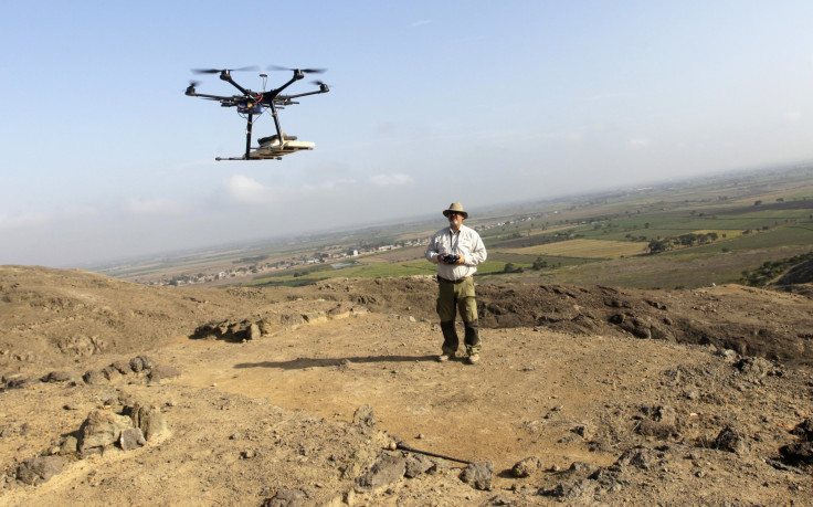
As the prices of drones have dropped over the past few years, people are finding more and more creative ways to use them. One group in particular that is taking advantage of the increased availability of unmanned aerial vehicles, or UAVs, is archaeologists.
For the past 40 years, scientists have looked for new and better methods to map archaeological sites. Thermal infrared imaging is certainly one way to spot structures buried under layers of sediment and forest growth, but acquiring satellites and helicopters to do so isn’t exactly affordable.
According to a new study published in the Journal of Archaeological Science, drones outfitted with heat-sensing cameras are opening up new opportunities for exploration and are changing how archaeologists work in the field. Researchers digging at the site of an ancient village in New Mexico say drones helped them uncover what they think are ceremonial pits, among other features, buried deep below the surface.
"Really within a few hours we were able to survey this area that took me a long time, years of what we call ground reconnaissance and excavation to see what's below the surface," John Kantner, a professor at the University of North Florida, told the Associated Press. "So this is great for quickly and pretty cheaply being able to find sites."
The site Kantner and his team are exploring is called Blue J. It is located in a remote area of northwestern New Mexico and was a cultural and religious fixture of ancient Puebloan society. Kantner discovered two households at the site’s edge through digging, but much of what Blue J has to offer remains buried under the earth.
The drones used by Kantner’s team detected large, unnatural circular shapes underneath the ground that archaeologists believe could be kivas – rooms used for religious rituals.
"We think we know a site, and we've been working there for a long time, and lo and behold, new technologies show us things we weren't even expecting," Sarah Parcak, an archaeologist at the University of Alabama in Birmingham who was not involved in the New Mexico research, told the AP. "The great thing about remote sensing is it really gives you a new set of eyes in the sky to see what is otherwise invisible."
Scientists are also considering using drones in other dry regions such as Saudi Arabia and Cyprus. In these kinds of environments, the difference in daytime and nighttime temperatures allows heat-sensing cameras to detect slight differences in heat signatures of buried stone structures.
Remote-controlled aircraft were originally developed for use by the military. But there’s more to unmanned aircraft than warfare. Drone technology is increasingly being applied elsewhere, including for things like monitoring ice floes in the Arctic, search and rescue, whale watching and tracking the movements of orangutans in Sumatra.
“There’s so much potential for drones,” Mike Winn, CEO of DroneDeploy, an unmanned aircraft startup, told Fox Business in a November 2013 interview. “The big thing a lot of people are talking about is agriculture. Farmers being able to use drones to better predict their crop yields, to be able to better manage their resources.”
The price of a basic drone starts at around $3,000 to $4,000, and some low-cost drones sell for less than $1,000.
This isn’t the first time drones have aided archaeologists in their field studies. Last year, scientists in Peru turned to drones to not only speed up slow survey work, but also to protect their sites from squatters and looters.
In March, a drone discovered ancient petroglyphs on a high canyon wall in southern Utah.
"A whole set of technologies have come together over the past five to seven years that makes drones extremely attractive," Austin Hill, an archaeologist and drone pilot with the University of Connecticut who is assisting with archaeological research in Jordan, told National Geographic. "You can attach magnetometers, barometers, GPS devices, and all sorts of cameras to these things. It gives you enormous amounts of useful data."
© Copyright IBTimes 2024. All rights reserved.
-
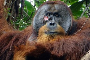
Self-care: Orangutan Seen Apparently Treating Wound
-

European Court Upholds Italy's Claim To Greek Bronze In US Museum
-

Colombian School, A Grim Reminder Of Atrocities Of Rubber Fever
-

More War Debris In Gaza Than Ukraine: UN
-
UK Confirms First Migrants Held For Rwanda Deportation Flights
-

Tesla To Cut Hundreds More Jobs In Musk Cost Push: Report
-

Microsoft Is Turning Into The 'Maestro' Of AI Transformation
-

US-Japan-Philippines Alliance: A Trio With Bitter Past Now Threatens China's Maritime Ambitions
-

Abu Dhabi-backed Group Ends Telegraph Takeover Bid
-
New Post-Brexit Controls: A Thorn For UK Horticulture


