

Gov't Says Broadband Divide Still Exists
As President Obama and other global leaders begin the push for universal broadband adoption, a recently released map attempts to visualize the digital divide problem in the U.S.
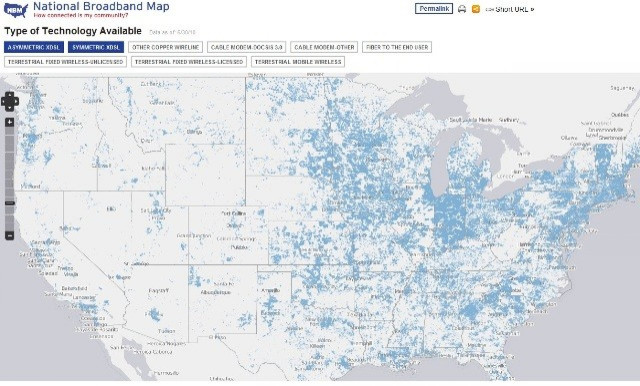
The map, released by the Department of Commerce's National Telecommunications and Information Administration (NTIA) department, shows the country's broadband Internet access. While it shows an improvement over last year's broadband access, the NTIA says there are still too many gaping white spots (indicating no access) on the map. A working definition of broadband is upload speeds of 3 Megabytes per second.
The National Broadband Map shows there are still too many people and community institutions lacking the level of broadband service needed to fully participate in the Internet economy. We are pleased to see the increase in broadband adoption last year, particularly in light of the difficult economic environment, but a digital divide remains, said NTIA Administrator Lawrence E. Strickling in a statement.
While most highly populated areas in the U.S. are covered by broadband, large portions of the Midwest and Rocky Mountain regions are still without access. The west coast, outside of its big cities, is particularly thin. All told, 5-10 percent of Americans, mostly in rural areas, lack access to broadband at speeds that support basic functioning on the web including downloading Web pages, photos, video and video conferencing.
The divide between the urban and rural areas was especially stark in California. Seventy percent of urban areas in the state have broadband, compared to 35 percent of rural areas.
The map and supporting data was released to help further the broadband access expansion and adoption movement. Congress actually asked the NTIA to create a map of this sort by Feb. 17. It was created in collaboration with the Federal Communications Commission using data that each state, territory and the District of Columbia collected from broadband providers or other data sources.
The release of the National Broadband Map, the first of its kind in the nation, is a significant milestone. This cutting-edge tool will continue to evolve with the help of new data and user feedback. It will provide consumers, companies and policymakers with a wealth of information about broadband availability, speeds, competition and technology, and help Americans make better informed choices about their broadband services, FCC Chairman Julius Genachowski said in a statement.
People can use the map, which can be accessed at http://www.broadbandmap.gov, to search by address to find the broadband providers and services available in that area. It will also be used by policymakers to compare broadband availability among geographic areas and across demographic groups, which can inform policies to support private sector investments.
To contact the reporter responsible for this story call (646) 461 6917 or email j.emspak@ibtimes.com.
© Copyright IBTimes 2025. All rights reserved.
- MOST POPULAR IN Technology


