

Hurricane Irene: Path to New York City
Hurricane Irene reached 120 mph as it intensified, ravaging Acklins and Crooked Islands in the southeastern Bahamas. The National Hurricane Center said that Irene is a large and dangerous storm and that it is expected to gain momentum in the next day. The hurricane could become a Category 4 hurricane, the NHC said.
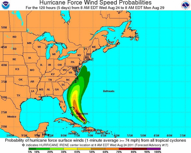
Forecasters said that the hurricane is heading northwest, suggesting that it will likely spare Florida. The area of concern is North Carolina to New England, where it will make landfall later this week.
It got really bad this morning at 10, administrator of Mayaguana Island in the Bahamas Harvey Roberts told the Miami Herald at 1:30 p.m. Things are pretty rough. The top of a neighbor's roof is in my yard. A lot of trees are down. The wind is blowing really, really hard, he added.
Roberts also told the Miami Herald that a church lost its side in Abraham Bay and that a utility pole ignited after a tree fell on it. The island is home to 300 people.
Officials in New York and New Jersey urged residents to prepare for Hurricane Irene, which is headed toward the East Coast.
The hurricane should make landfall in North Carolina by Saturday and is expected to travel upwards along the coast.
Everybody should keep an eye on the storm and pay attention to the Office of Emergency Management, Mayor Bloomberg said at a press conference Tuesday. And if this one doesn't hit us, the likelihood of others is very great. We'll likely get a few storms for sure here, he added.
© Copyright IBTimes 2025. All rights reserved.
- MOST POPULAR IN Society


