

Irene Path: Powerful Storm Aiming at New York, Boston, Philadelphia
Hurricane Irene threatens to batter the U.S. East Coast, perhaps making a direct strike on New York City, as sharpened forecast models show the storm has the makings of the hurricane of a lifetime for Mid-Atlantic and Northeast areas.
Forecasters say Irene is now a major Category 3 storm that could strengthen before making landfall this weekend. The storm holds the potential, forecasters say, to wreak havoc along the East Coast, with torrential rains, high winds, downed trees, flooding and power outages in major metropolitan areas including Philadelphia, New York, and Boston by late Sunday.
New Jersey Gov. Chris Christie has signed a declaration of emergency to mobilize the National Guard in preparation for the storm.
Christie said the move will allow the National Guard to begin working throughout the state to prepare for the approaching storm that The Weather Channel is calling an extraordinary threat for the Mid-Atlantic and Northeast U.S.
The governor urged anyone planning to go to the Jersey Shore this weekend not to go. He said Hurricane Irene will be a serious, significant event for the state, adding, This is not just going to be a shore incident; this is going to be a statewide incident.
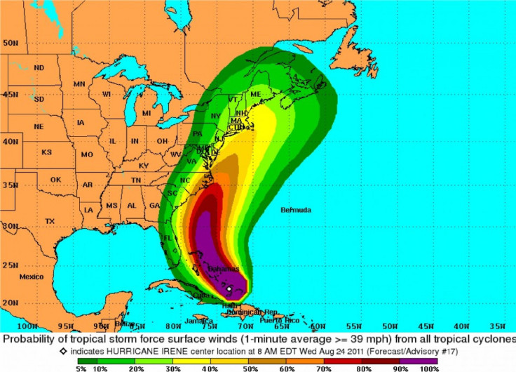
Unusually large and powerful, Hurricane Irene is plodding slowly but surely on a path that's pushing the massive storm toward possible landfall on the North Carolina coast Saturday before assaulting the Northeast's I-95 corridor late Sunday. Forecast models show Irene could make a direct hit on the New York City region, including parts of New Jersey.
With hurricane force winds of at least 74 mph extending 70 miles from its center, and tropical-storm force winds extending another 255 miles in all directions, the storm is packing winds of 115 mph and forecasters say it could strengthen before hitting North Carolina's Outer Banks over the weekend.
As Irene threatens to become one of the most devastating storms to hit the Northeast in recent memory, officials from throughout the region, including the largest cities began to make emergency plans.
After lashing the Bahamas on Wednesday, Irene is moving up the East Coast at a crawl, but grabbing the attention of millions of residents who lie in its forecasted path. The first hurricane of the 2011 Atlantic season is posing an extreme threat to the East Coast -- with the potential to become historic before it sweeps away from the U.S. mainland by late Monday or early Tuesday.
Irene is centered about 100 miles east-northeast of Nassau, and moving northwest at 13 mph. The hurricane could still be a major one, causing extreme impacts to eastern North Carolina later Friday night and Saturday. With winds over 100 mph, torrential rainfall, ocean and sound flooding and a damaging storm surge are expected on the Outer Banks and western shores of the sounds.
Forecasters say hurricane force winds could be felt over the mainland almost to I-95 late into the weekend. Also, the storm track forecast models show that Irene may hug the coastline, potentially making landfall not too far east of New York City Sunday evening.
New York Mayor Michael Bloomberg is urging city residents to focus on potential damage Irene could cause, in a rare hurricane strength strike.
He met with city officials Wednesday preparing emergency plans. Forecasts suggest Irene could make a direct hit on New York late Sunday, ravaging the metro area with flooding, hurricane strength winds, downed power lines, power outages and downed trees and possibly broken windows and flying debris.
Things happen in the city, Bloomberg said, at a briefing after the city experienced an earthquake this week. Quite honestly, I am more concerned about our preparations for a hurricane that's approaching...Everyone should keep an eye on the storm and pay attention to the office emergency management when they put out some advisories on what we should prepare for as we get closer to the potential storm.
In North Carolina, many residents and tourists on the Outer Banks are evacuating as the storms moves that way, with potential of a landfall.
There's going to be flooding, there's going to be heavy rain, National Weather Service meteorologist Mike Rusnak told the Virginia Pilot. It's just a matter of the exact track because it's still two days out and it's still too early to try to figure out out what kind of numbers to give here.
Irene is threatening to become the first major hurricane to hit the East Coast since Wilma struck Florida in 2005. Hurricane Ike was the last storm to make U.S. landfall, in 2008.
The storm could strengthen Thursday to a Category 4, with 135 mph winds, the National Hurricane Center said, but it will likely decrease in strength once it climbs higher up the East Coast through colder water. Still, few storms reach the New York area at hurricane strength. Thus, Irene's big threat is grabbing headlines and attention Thursday.
Weather Channel experts called Irene's threat to North Carolina coastal areas and the high-population northeast corridor particularly threatening and notes it is best for people to be on alert.
Computer models have sharpened over the past 24 hours and the latest forecasts early Thursday show rare storm potency for portions of the Northeast. Irene is expected to approach the Carolinas late Friday night through Saturday, with Northeast U.S. impacts continuing into the weekend and early Monday of next week.
The governors of New York and Connecticut ordered agencies to make ready for the storm. In Rhode Island, officials plan to activate a 24-hour operations center, said Denis Riel, a spokesman for the Federal Emergency Management Agency.
Hurricane Bill was the last hurricane to strike the tri-state New York area back in 2009 and only minor damage was reported.
Nassau County Executive Ed Mangano on Wednesday warned residents to be prepared.
This is a good time to get prepared again in your homes, he said. There's items that you should stock up on, those that need to move or possibly be evacuated, perhaps seniors should think about having their medications refilled and having enough on hand.
© Copyright IBTimes 2025. All rights reserved.
- MOST READ


