

Nepal Earthquake 2015: What Regions Of The U.S. Are At Risk For A Major Earthquake?

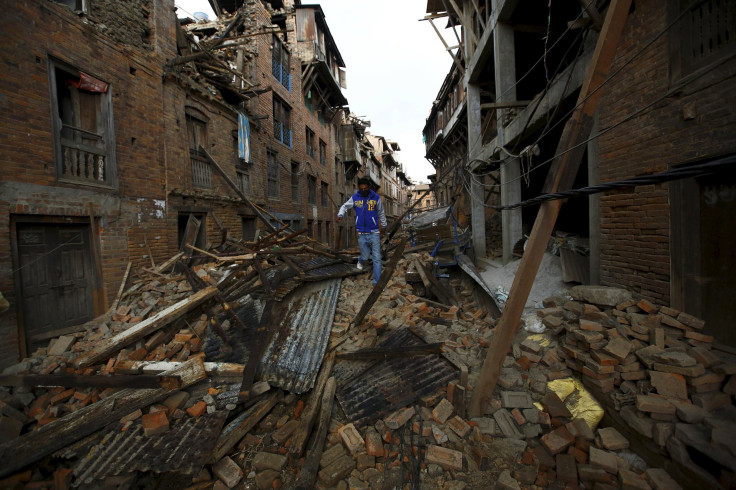
The magnitude-7.8 earthquake that hit just outside Kathmandu, Nepal, on Saturday may have occurred on the opposite side of the planet from most Americans, but a natural disaster of that power could easily happen within the United States. The U.S. is full of fault lines that have built up enough tension to make seismologists murmur warnings about the vulnerability of three regions in particular to a major earthquake, even if the cost of such an event in human lives would likely be lower thanks to modern building codes.
Just last week, the Seismological Society of America reported that more than 143 million Americans in the lower 48 states are susceptible to some form of damage from earthquakes in their lifetime. Though the West Coast gets much of the attention for the risks posed by a series of well-known faults in that region, The U.S. Geological Survey updated the nation’s official map of seismic hazards last year to reflect greater risks in Missouri and Illinois as well as along the East Coast:
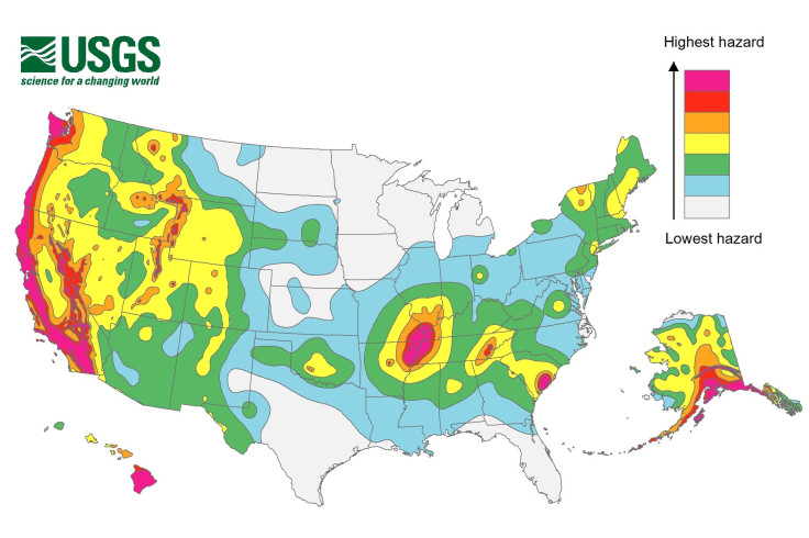
The portion of the central U.S. known as the New Madrid Seismic Zone is the most seismically active area in the U.S. east of the Rocky Mountains. It lies at the intersection of Missouri, Arkansas, Tennessee, Kentucky and Illinois and contains a series of active faults. Seismologists don’t know as much about these faults as those on the West Coast because they are buried far beneath thick layers of soft soils in which evidence of seismic activity quickly fades.
The Missouri Department of Natural Resources says there is a 7 to 10 percent chance that a magnitude-7.5 to -8.0 earthquake could occur in this region and that the area is already “about 30 years overdue” for a magnitude-6.3 earthquake based on the historic record of seismic activity.
The USGS wrote in a 2009 fact sheet that Memphis, Tennessee and St. Louis would be hit particularly hard if such a shake were to occur. “Memphis has an aging infrastructure, and many of its large buildings, including unreinforced schools and fire and police stations, would be particularly vulnerable when subjected to severe ground shaking,” the agency stated. “Relatively few buildings were built using building codes that have provisions for seismic-resistant design.”
Still, the potential damage that earthquakes in the U.S. could bring remains concentrated largely on the West Coast. The Seismological Society of America estimated that 80 percent of the projected $4.5 billion in annual economic damage from earthquakes that the U.S. will suffer over the coming decades will happen in just three states: California, Oregon and Washington.
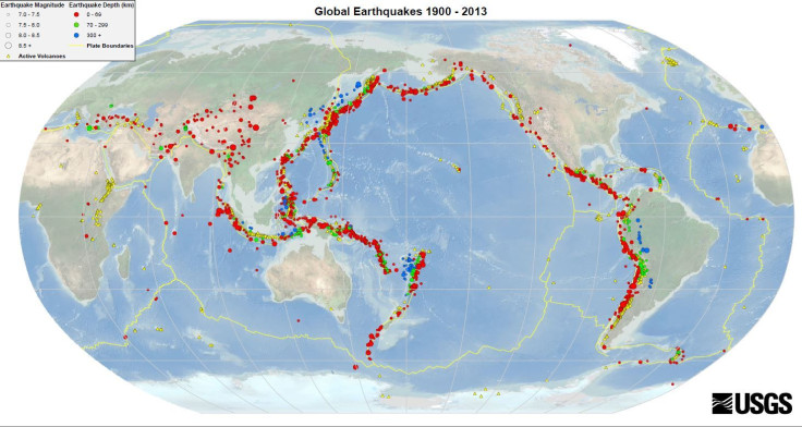
The West Coast experiences far more earthquakes than the East Coast, and 81 percent of the world's largest earthquakes occur along the Pacific Rim. Alaska endures the most earthquakes of any state but they inflict relatively little damage due to the state's low population. Of all the earthquakes that occurred worldwide between 1900 and 2013, the vast majority took place along the coast of the Pacific Ocean, as seen in this map provided by USGS:
Scientists have repeatedly said that the chances of a major earthquake occurring within the lifetime of current residents in California and the Pacific Northwest are significant. “The probability that a major earthquake will hit the western United States in coming decades is high,” Richard Allen, a seismologist at the University of California, Berkeley, warned in a 2013 comment in Nature.
A study published to the Bulletin of the Seismological Society of America last year showed that four faults in California that comprise the San Andreas Fault system -- the Hayward Fault, Rodgers Creek Fault, Green Valley Fault and Calaveras Fault -- have built up enough tension to trigger major earthquakes. These same faults undercut the state’s largest cities, including San Francisco and Los Angeles.
“If you are in the middle of the Bay Area, you are near a whole lot of faults, and I'm concerned about all of them," Jim Lienkaemper, lead author and a geophysicist at the USGS Earthquake Science Center in Menlo Park, California, told LiveScience.
In fact, scientists are 60 to 70 percent certain that California will experience an earthquake of at least a magnitude 6.7 in the next 30 years, based on the latest estimates, which indicate that such an earthquake occurs about once every 6.3 years. In 1994, an earthquake of that size near Los Angeles, known as the Northridge quake, killed 60 people while injuring 7,000. Even larger were the magnitude-6.9 Loma Prieta earthquake of 1989 and magnitude-7.8 San Francisco earthquake of 1906, both in Northern California.
Earlier this year, the USGS raised the odds from 4.7 percent to 7 percent that California would suffer a magnitude-8.0 earthquake or greater in the next 30 years.
The odds look even worse for the Pacific Northwest, as Oregon, Washington and Northern California face an 80 percent chance of a major earthquake occurring along the southern end of the powerful 680-mile-long Cascadia fault that runs just 50 miles off the coast.
Though modern building codes have lowered the risk of Americans dying in these events, vulnerable spots persist in the nation’s infrastructure -- high-rises in Seattle that were built prior to 1994 when such codes were adopted remain vulnerable, NBC News reports, while Oregon has at least 1,300 schools and public buildings that are in danger of collapsing in such a quake.
© Copyright IBTimes 2024. All rights reserved.
-

G7 Holds 'Strategic' Talks In Climate Hotspot Italy
-

Will He Resign Or Not? Spain Awaits PM's Decision
-

Olympic Deal Shows Bubbling Market For Zero-alcohol Beers
-
Migrants Eyeing Europe Bide Their Time In Tunisia
-

Fed's Favored Inflation Measure Accelerates, Dimming Rate Cut Hopes
-

Barking Mad? Milei's Attachment To 'Dead' Dog Raises Sanity Worries
-

Microsoft Expands Its AI Empire Abroad
-

Oil: 'Mother Of Corruption' In Venezuela
-

'Extreme' Climate Blamed For World's Worst Wine Harvest In 62 Years
-

Macron Warns 'Mortal' Europe Needs Credible Defence


