

Texas Oil Drilling Causes Alarming Increase Of Land Sinking, Satellite Images Show
Decades of oil production across vast swathes of Texas has taken its toll on the very land itself which is “sinking and uplifting” at an alarming rate, according to a team of geophysicists from Southern Methodist University (SMU) in Dallas.
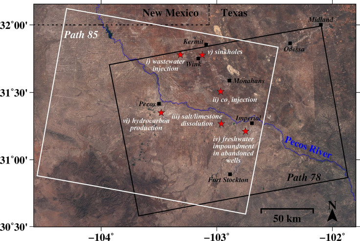
Researchers discovered that territory spread across four Texas counties is experiencing a worry increase in land destabilization. Satellite radar images obtained by the European Space Agency (ESA) revealed significant ground movement across a 4,000-square-mile area. According to the researchers, in one particular area, the ground had moved by as much as 40 inches in just two-and-a-half years.
“The ground movement we’re seeing is not normal. The ground doesn’t typically do this without some cause,” geophysicist Zhong Lu, who is a professor at SMU and an expert in satellite radar imagery analysis, said in a statement. “These hazards represent a danger to residents, roads, railroads, levees, dams, and oil and gas pipelines, as well as potential pollution of ground water,” Lu said. “Proactive, continuous detailed monitoring from space is critical to secure the safety of people and property.”
The scientists studied medium-resolution satellite images that were captured between November 2014 and April 2017 and cover areas within four Texan oil-patch counties. The areas observed include the towns of Pecos, Monahans, Fort Stockton, Imperial, Wink and Kermit.
Around 5.5 miles from Pecos, researchers detected over 1 inch of subsidence near new oil wells. Over the past few years, this area has also experienced six small earthquakes, indicating the ground instability accrued stress and led to existing faults slipping.
“We have seen a surge of seismic activity around Pecos in the last five to six years. Before 2012, earthquakes had not been recorded there. At the same time, our results clearly indicate that ground deformation near Pecos is occurring,” Kim said. “Although earthquakes and surface subsidence could be coincidence, we cannot exclude the possibility that these earthquakes were induced by hydrocarbon production activities.”
The radar images, as well as oil-production data from the Railroad Commission of Texas, indicated the area’s land instability is linked to decades of oil-production activities. The researchers warned this ground movement may extend beyond what was captured by satellite images.
“We’re fairly certain that when we look further, and we are, that we’ll find there’s ground movement even beyond that,” said Jin-Woo Kim, a research scientist in the SMU and co-author of the new study. “This region of Texas has been punctured like a pin cushion with oil wells and injection wells since the 1940s and our findings associate that activity with ground movement.”
The findings of the new research have been published in the journal Scientific Reports.
© Copyright IBTimes 2025. All rights reserved.
- MOST POPULAR IN National


