

Tropical Storm Hermine Live Updates: Soon-To-Be Hurricane Threatens Florida

UPDATE: 4:25 p.m. EDT — The flooding has begun in earnest in Florida, where Hurricane Hermine was approaching land Thursday. Residents posted photos and videos on social media of water pooling along the coast:
Water coming onto the lots in Mashes Sands... pic.twitter.com/nhzC5k5NXT
— N FL / S GA Skywarn (@NFL_Skywarn) September 1, 2016
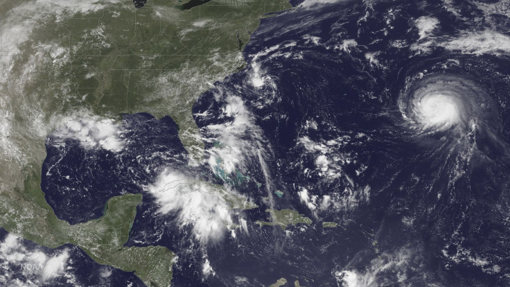
UPDATE: 3:40 p.m. EDT — The newly recategorized Hurricane Hermine was about 115 miles south-southwest of Apalachicola, Florida, Thursday afternoon, and moving at about 14 mph. Though it's just a Category 1 storm, the upgrade is significant: When it moves over Florida tonight, the storm will be the first Atlantic hurricane to make landfall in more than 10 years.
More than 100 counties in Florida and Georgia were under a state of emergency as residents prepared for the storm. Dozens of schools had canceled classes Friday, including the University of North Florida. A tornado watch was issued through 11 p.m. for much of central and north Florida.
A tornado watch has been issued for parts of Florida until 11 PM EDT pic.twitter.com/1fM0erFeM7
— NWS Tampa Bay (@NWSTampaBay) September 1, 2016
Strongest winds in #Hermine may come ashore more than an hour before landfall #flwx pic.twitter.com/8KESDH4eWE
— Greg Postel (@GregPostel) September 1, 2016
Current conditions Ben T Davis beach
— Larry Towe (@LarryToweTV) September 1, 2016
Tampa.
Beach is missing, possibly submerged#Hermine @FOX13News @PaulFox13 pic.twitter.com/CWEl51fmpY
#Hermine 1 | Dock 0. Check out this video from Craig M. of the dock at Shark Tales Restaurant @ St Pete Beach. #WFLA pic.twitter.com/ZhVo0tQCnj
— WFLA NEWS (@WFLA) September 1, 2016
UPDATE: 3:03 p.m. EDT — Tropical Storm Hermine has officially become a hurricane.
Data from USAF hurricane hunter finds #Hermine is now a hurricane. Max sustained winds to near 75 mph (120 km/h). https://t.co/tW4KeGdBFb
— National Hurricane Center (@NHC_Atlantic) September 1, 2016
UPDATE: 2:54 p.m. EDT — At least six homes had to be evacuated Thursday in Largo, Florida, due to flooding from Tropical Storm Hermine, WFTS reported. Larger-scale evacuations were ongoing, with mandatory orders for residents to leave in parts of Dixie, Wakulla and Franklin counties, according to the Weather Channel.
The Ocala Star-Banner has temporarily taken down its paywall so people can access information about the storm.
I'm in Redington Shores now. The Intracoastal has risen over the sea wall. This is wild. #tbttropical #Hermine pic.twitter.com/n8mi73Pk8w
— Kathryn Varn (@kathrynvarn) September 1, 2016
Gulf entering some backyards along U.S. 98 in Fla's Big Bend. #TSHermine pic.twitter.com/WFSOFOYkrj
— John Kennedy (@JKennedyReport) September 1, 2016
UPDATE: 2:25 p.m. EDT — Tropical Storm Hermine — which is due to become a hurricane before it makes landfall in Florida late Thursday — is "life-threatening," Gov. Rick Scott told reporters, according to the Los Angeles Times.
"We’re going to have storm surge, wind, rain," he said. "We’re going to have flooding. All of this together, and parts of it by itself, is life-threatening."
Tornado warnings were issued Thursday afternoon in Blanton and Croom near Tampa as the water rose in Cedar Key.
Not something you see every day. Hang tight north Florida. Conditions going down hill from here. #Hermine pic.twitter.com/6azyENVq76
— Michael Lowry (@MichaelRLowry) September 1, 2016
Last night and now. Water coming up fast. #Hermine 4 feet in 30 min pic.twitter.com/cpCgMmk0no
— Jim Edds (@ExtremeStorms) September 1, 2016
UPDATE: 1:51 p.m. EDT — The University of Florida in Gainesville will close its campus for the weekend at 4 p.m. EDT Thursday as a result of the approaching tropical storm, it announced on social media. Meanwhile, the National Hurricane Center issued an update that maximum sustained winds in Tropical Storm Hermine have increased to 70 mph.
"Hurricane conditions are expected to reach the coast within the warning area beginning tonight," the center wrote.
Getting briefed on impacts of Hermine - be prepared, listen to your local officials, and follow your disaster plan. pic.twitter.com/korTCL2BU5
— Rick Scott (@SenRickScott) September 1, 2016
UPDATE: 12:10 p.m. EDT — Florida Gov. Rick Scott tweeted morning that Tropical Storm Hermine will likely make landfall at about 2 a.m. EDT. "Severe effects" will start at about 6 p.m.
Floridians must already have a plan in place and all of the resources your family needs, such as 3 days of food & water, flashlights, etc.
— Rick Scott (@SenRickScott) September 1, 2016
Meanwhile, Georgia Gov. Nathan Deal declared a state of emergency for 56 counties starting at noon and going through Saturday. "Georgia is expected to receive severe weather related to Tropical Storm Hermine through Saturday," Deal said in a statement. "We are working to ensure counties in south, central and coastal Georgia have access to the state resources necessary to prepare and respond when Tropical Storm Hermine enters Georgia. Our Emergency Operations Command will continue closely monitoring this storm and additional counties may be included in this declaration as needed."
Due to #Hermine's large size, its available kinetic energy is already roughly equivalent of a Cat 1 Hurricane. pic.twitter.com/HxiGEcavhp
— Eric Holthaus (@EricHolthaus) September 1, 2016
UPDATE: 11:11 a.m. EDT — "Life-threatening surge and flooding rains" were forecast for Florida Thursday in a National Hurricane Center bulletin on Tropical Storm Hermine. The storm was located about 170 miles south-southwest of Apalachicola as of 11 a.m. EDT. It was moving at 14 mph.
As a result of the bad weather, Florida State University announced it would close its main campus at noon. Also, the Kenny G concert scheduled for Thursday night in Jacksonville got postponed, according to First Coast News.
Hermine forecast track has moved back to the east. Still much uncertainty in storm track and impacts this weekend pic.twitter.com/Ggk9px1QZH
— NWS Eastern Region (@NWSEastern) September 1, 2016
Anyone wanna go to the beach!? #hermine pic.twitter.com/1lfPnDOogJ
— pete butera (@peteybutes) September 1, 2016
Walk with me, on my journey to more hurricane supplies. #Hermine pic.twitter.com/75fXkX6dSU
— Matt Reagan (@MattReaganWX) August 31, 2016
Original story:
Florida may be about to get its first hurricane in more than a decade. Tropical Storm Hermine was hurtling toward the Gulf Coast Thursday morning, threatening cities like Tallahassee and Tampa as it strengthened in the Atlantic Ocean.
A National Hurricane Center update from 8 a.m. EDT put the storm system about 200 miles south-southwest of Apalachicola, Florida, moving north-northeast with maximum sustained winds of 65 mph. The eye was on track to reach the coast late Thursday.
"Additional strengthening is anticipated, and Hermine is expected to be a hurricane by the time landfall occurs," the center wrote. "Preparations to protect life and property should be rushed to completion."
The system was forecast to drop between 5-10 inches of rain in Florida and Georgia, with some areas getting up to 20 inches and experiencing flash flooding. Tornadoes were possible, as well. Hurricane and tropical storm warnings and watches were in effect for most of Florida's west coast Thursday.
Tropical Storm #Hermine expected to make landfall on Florida coast late tonight/early Fri: https://t.co/Wg3bNtZnpm pic.twitter.com/AzPdKCEIsS
— Good Morning America (@GMA) September 1, 2016
If Hermine hits Florida as a hurricane, it'll be the first one since 2005's Hurricane Wilma, WFTV reported.
Gov. Rick Scott referenced that fact as he declared a state of emergency for 51 counties Wednesday. "Fortunately we haven't had a hurricane in a long time, so people often get complacent. So just think about this: Follow the news, have a battery powered radio in case you lose your power so you can follow," WCJB reported he said at a news conference.
School was canceled in Hillsborough County and at the University of South Florida on Thursday. The Busch Gardens theme park closed its doors, as well.
Weather Channel meteorologist Kevin Roth told NBC News that locals should get ready in case of evacuations. "Residents in Florida need to pay attention to the latest that Hermine is doing," he said. "It could be a very lousy holiday weekend for a large part of the population."
In Florida beer is on the storm prep list pic.twitter.com/ThJv4dUB1P
— Gary Fineout (@fineout) September 1, 2016
© Copyright IBTimes 2025. All rights reserved.
- MOST POPULAR IN National


