

West Coast of U.S. Expects Tsunamis Up To 8 feet
The national Oceanographic and Atmospheric Administration has issued tsunami warnings for coastal regions in California, Oregon and Washington, in the wake of a magnitude 8.9 earthquake off the coast of Japan.
A tsunami warning means people should evacuate coastal areas. For Washington, a tsunami advisory is in effect, meaning that residents should stay away from the beaches and be prepared for possible damage from surging waters. In California, the tsunami warning applies to the entire coast to Point Concepcion, a few miles from San Luis Obispo. South of that point the state is under tsunami advisory.
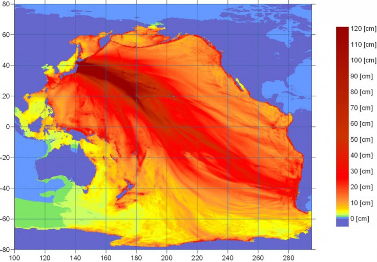
The first waves are predicted to hit Neah Bay on the coast of Washington at about 7 a.m. local time (10 a.m. Eastern). Waves will reach Cascade Head, Ore., about 70 miles southwest of Portland, about 10 minutes later. Over the next hour the waves will make their way down the California coast, reaching Port Concepcion by 7:57 a.m. (10:57 a.m. Eastern) and Alamitos Bay, near Long Beach, Calif., at 8:46 a.m. (11:46 a.m. Eastern).
Crescent City, Calif., just a few miles south of the border with Oregon, is expected to see the highest waves, cresting at 2.5 meters, or 8.2 feet, while at the mouth of the Klamath River it is expected to be at about 2 meters (6.5 feet). Port San Luis, about 90 miles northwest of Santa Barbara, is also expected to experience wave heights of 2 meters or more.
In Oregon, the biggest waves will likely arrive at Siletz Bay, with heights of 2.23 meters (7.3 feet).
Washington will likely experience smaller wave heights. The town of Moclips, 60 miles southwest of Seattle, will probably see s surge of about 1 meter, and that will be among the highest in the state.
Tsunamis are caused by the vibrations of the sea floor during earthquakes. The energy and height of the wave when it hits the shoreline depend on the direction it faces. Often tsunamis don't look like classic surf waves at all, but more like rapidly rising water. But the force the water hits with can be substantial - a single cubic meter of water weighs a metric ton, and tsunamis move fast enough to cross the Pacific in less than a day.
© Copyright IBTimes 2024. All rights reserved.
-

Oil: 'Mother Of Corruption' In Venezuela
-

'Extreme' Climate Blamed For World's Worst Wine Harvest In 62 Years
-

Macron Warns 'Mortal' Europe Needs Credible Defence
-

Bitcoin And Crypto Price Review - Another Myth Gets Busted?
-

Mass Cancellations Loom Despite French Air Union Cancelling Strike
-

Mired In Crisis, Boeing Reports Another Loss
-

Recycled 'Zombie' Misinformation Targets US Voters
-

Hackers Leak Part Of Source Code Of El Salvador's Bitcoin Wallet
-

Azerbaijan Says 'Closer Than Ever' To Armenia Peace Deal Amid Border Talks
-

How UK's Biggest Water Supplier Sank Into Crisis


